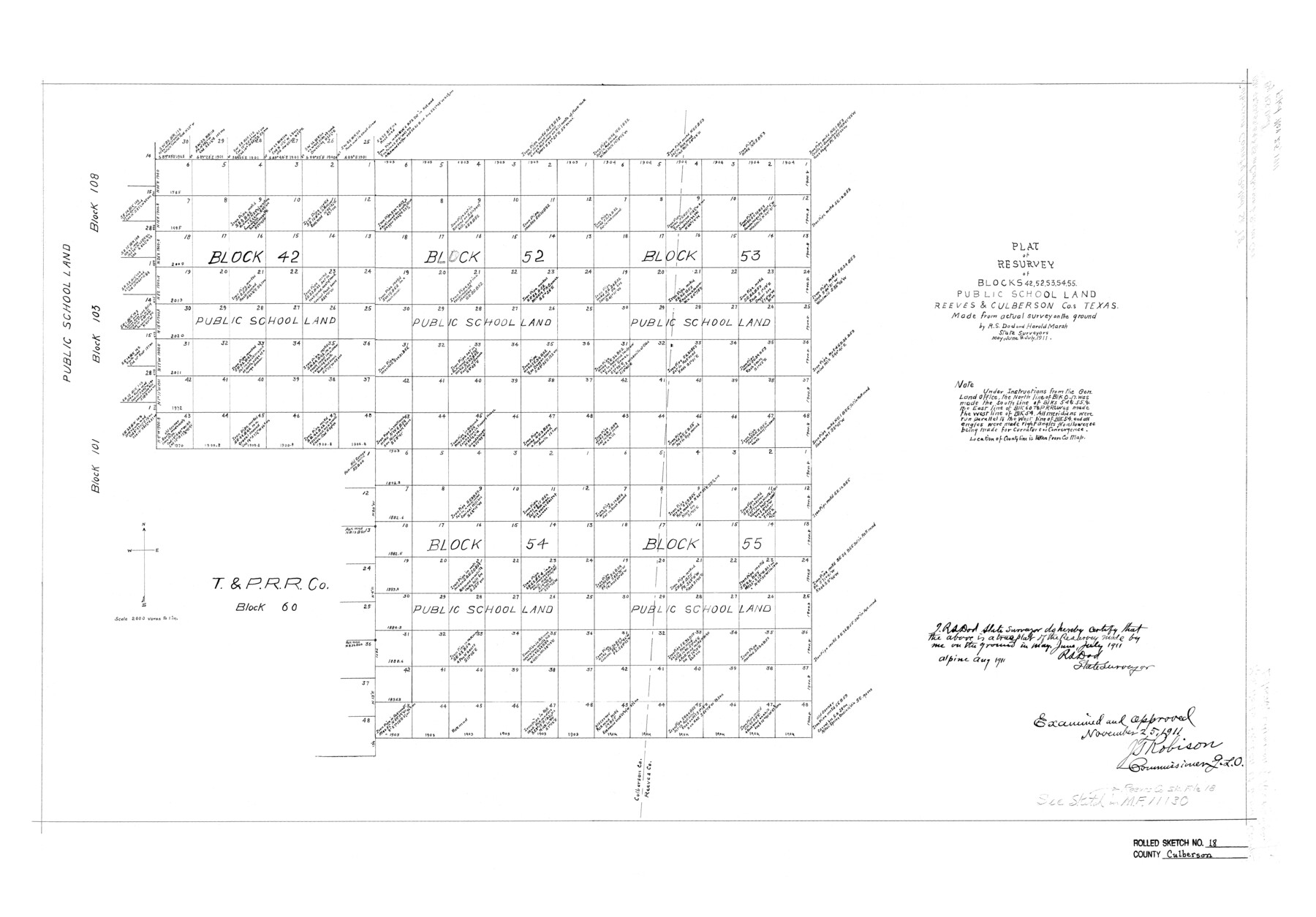
Culberson County Rolled Sketch 18
Plat of resurvey of Blocks 42, 52, 53, 54, 55 Public School Land, Reeves & Culberson Cos., Texas made from actual survey on the ground
-
Map/Doc
5650
-
Collection
General Map Collection
-
Object Dates
8/1911 (Creation Date)
11/25/1911 (File Date)
-
People and Organizations
Harold Marsh (Surveyor/Engineer)
R.S. Dod (Surveyor/Engineer)
-
Counties
Culberson Reeves
-
Subjects
Surveying Rolled Sketch
-
Height x Width
24.1 x 34.5 inches
61.2 x 87.6 cm
-
Scale
1" = 2000 varas
Part of: General Map Collection
Flight Mission No. BQY-15M, Frame 4, Harris County

Print $20.00
- Digital $50.00
Flight Mission No. BQY-15M, Frame 4, Harris County
1953
Size 18.6 x 22.4 inches
Map/Doc 85302
Map of Calhoun County Texas

Print $20.00
- Digital $50.00
Map of Calhoun County Texas
1911
Size 27.7 x 34.3 inches
Map/Doc 4514
Controlled Mosaic by Jack Amman Photogrammetric Engineers, Inc - Sheet 23

Print $20.00
- Digital $50.00
Controlled Mosaic by Jack Amman Photogrammetric Engineers, Inc - Sheet 23
1954
Size 20.0 x 24.0 inches
Map/Doc 83474
Kimble County Sketch File 39

Print $12.00
- Digital $50.00
Kimble County Sketch File 39
1885
Size 14.1 x 8.6 inches
Map/Doc 28997
Traced from Genl. Arista's map captured by the American Army under Genl. Taylor at Resaca de la Palma 9th May '46 and presented to James K. Polk, President U. States

Print $20.00
- Digital $50.00
Traced from Genl. Arista's map captured by the American Army under Genl. Taylor at Resaca de la Palma 9th May '46 and presented to James K. Polk, President U. States
1846
Size 18.2 x 27.3 inches
Map/Doc 73060
Menard County Sketch File 25A

Print $20.00
- Digital $50.00
Menard County Sketch File 25A
1936
Size 23.0 x 17.8 inches
Map/Doc 12078
Hardin County Rolled Sketch WS

Print $20.00
- Digital $50.00
Hardin County Rolled Sketch WS
1936
Size 25.4 x 43.9 inches
Map/Doc 9104
Location Survey of the Southern Kansas Railway, Kiowa Extension from a point in Drake's Location, in Indian Territory 100 miles from south line of Kansas, continuing up Wolf Creek and South Canadian River to Cottonwood Creek in Hutchinson County

Print $20.00
- Digital $50.00
Location Survey of the Southern Kansas Railway, Kiowa Extension from a point in Drake's Location, in Indian Territory 100 miles from south line of Kansas, continuing up Wolf Creek and South Canadian River to Cottonwood Creek in Hutchinson County
1886
Size 38.9 x 36.0 inches
Map/Doc 88838
El Paso County Sketch File 35 (4)

Print $38.00
- Digital $50.00
El Paso County Sketch File 35 (4)
1886
Size 14.3 x 9.0 inches
Map/Doc 22199
Kenedy County Rolled Sketch 15

Print $15.00
- Digital $50.00
Kenedy County Rolled Sketch 15
1942
Size 10.2 x 15.2 inches
Map/Doc 46426
Flight Mission No. DCL-7C, Frame 44, Kenedy County

Print $20.00
- Digital $50.00
Flight Mission No. DCL-7C, Frame 44, Kenedy County
1943
Size 15.4 x 15.2 inches
Map/Doc 86032
Chambers County Sketch File 34

Print $10.00
- Digital $50.00
Chambers County Sketch File 34
1951
Size 14.3 x 8.8 inches
Map/Doc 17620
You may also like

Edwards County Boundary File 2

Print $28.00
- Digital $50.00
Edwards County Boundary File 2
Size 11.2 x 8.6 inches
Map/Doc 52862
[Part of Block XR along New Mexico State Line]
![90665, [Part of Block XR along New Mexico State Line], Twichell Survey Records](https://historictexasmaps.com/wmedia_w700/maps/90665-1.tif.jpg)
Print $20.00
- Digital $50.00
[Part of Block XR along New Mexico State Line]
Size 22.2 x 5.5 inches
Map/Doc 90665
Terrell County Working Sketch 18

Print $20.00
- Digital $50.00
Terrell County Working Sketch 18
1929
Size 14.3 x 21.3 inches
Map/Doc 62167
Potter County Sketch File 7

Print $20.00
- Digital $50.00
Potter County Sketch File 7
Size 23.2 x 18.0 inches
Map/Doc 12197
Polk County Sketch File 30

Print $18.00
- Digital $50.00
Polk County Sketch File 30
1934
Size 14.1 x 8.5 inches
Map/Doc 34206
Cherokee County Working Sketch 11

Print $20.00
- Digital $50.00
Cherokee County Working Sketch 11
1957
Size 24.3 x 20.2 inches
Map/Doc 67966
Runnels County Rolled Sketch B

Print $20.00
- Digital $50.00
Runnels County Rolled Sketch B
1891
Size 17.4 x 19.3 inches
Map/Doc 7540
Kaufman County

Print $20.00
- Digital $50.00
Kaufman County
1896
Size 44.0 x 28.0 inches
Map/Doc 3751
The Nashville Association/Company Empresario Colony. October 15, 1827

Print $20.00
The Nashville Association/Company Empresario Colony. October 15, 1827
2020
Size 14.7 x 21.7 inches
Map/Doc 96001
Plat of Surveys in Hidalgo Co.

Print $20.00
- Digital $50.00
Plat of Surveys in Hidalgo Co.
Size 17.3 x 8.4 inches
Map/Doc 75547
Burnet County Sketch File 6

Print $8.00
- Digital $50.00
Burnet County Sketch File 6
1854
Size 10.1 x 8.1 inches
Map/Doc 16682