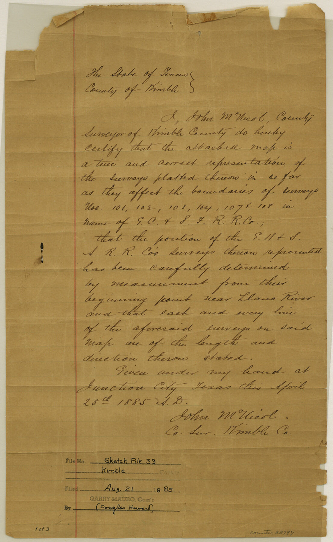
Kimble County Sketch File 39
[Connecting line southeast of Junction]
-
Map/Doc
28997
-
Collection
General Map Collection
-
Object Dates
10/22/1885 (Creation Date)
11/25/1885 (File Date)
-
People and Organizations
John McNicol (Surveyor/Engineer)
-
Counties
Kimble
-
Subjects
Surveying Sketch File
-
Height x Width
14.1 x 8.6 inches
35.8 x 21.8 cm
-
Medium
paper, manuscript
-
Comments
See Kimble County Rolled Sketch 12 (6507) for sketch.
-
Features
Llano River
Related maps
Kimble County Rolled Sketch 12

Print $20.00
- Digital $50.00
Kimble County Rolled Sketch 12
Size 24.6 x 26.2 inches
Map/Doc 6507
Part of: General Map Collection
Fractional Township No. 7 South Range No. 2 West of the Indian Meridian, Indian Territory

Print $20.00
- Digital $50.00
Fractional Township No. 7 South Range No. 2 West of the Indian Meridian, Indian Territory
1898
Size 19.2 x 24.4 inches
Map/Doc 75195
Irion County Rolled Sketch 13

Print $20.00
- Digital $50.00
Irion County Rolled Sketch 13
1948
Size 27.0 x 30.7 inches
Map/Doc 6323
Louisiana and Texas Intracoastal Waterway

Print $20.00
- Digital $50.00
Louisiana and Texas Intracoastal Waterway
1929
Size 13.6 x 19.8 inches
Map/Doc 83345
Pecos County Sketch File 116

Print $6.00
- Digital $50.00
Pecos County Sketch File 116
1913
Size 10.9 x 8.8 inches
Map/Doc 34092
Harrison County Working Sketch 26

Print $20.00
- Digital $50.00
Harrison County Working Sketch 26
1986
Size 38.4 x 30.0 inches
Map/Doc 66046
Flight Mission No. BQR-9K, Frame 45, Brazoria County

Print $20.00
- Digital $50.00
Flight Mission No. BQR-9K, Frame 45, Brazoria County
1952
Size 18.7 x 22.3 inches
Map/Doc 84049
Map showing survey for proposed ship channel from Brownsville to Brazos Santiago Pass

Print $20.00
- Digital $50.00
Map showing survey for proposed ship channel from Brownsville to Brazos Santiago Pass
1912
Size 18.1 x 27.7 inches
Map/Doc 72904
Tom Green County

Print $20.00
- Digital $50.00
Tom Green County
1942
Size 43.5 x 24.8 inches
Map/Doc 77437
Flight Mission No. CRC-5R, Frame 42, Chambers County

Print $20.00
- Digital $50.00
Flight Mission No. CRC-5R, Frame 42, Chambers County
1956
Size 18.6 x 22.3 inches
Map/Doc 84961
Parmer County Working Sketch 2

Print $20.00
- Digital $50.00
Parmer County Working Sketch 2
1914
Map/Doc 71470
Walker County Working Sketch 10

Print $20.00
- Digital $50.00
Walker County Working Sketch 10
1935
Size 19.3 x 19.9 inches
Map/Doc 72290
Zapata County Rolled Sketch 17A

Print $40.00
- Digital $50.00
Zapata County Rolled Sketch 17A
1953
Size 40.6 x 52.2 inches
Map/Doc 10170
You may also like
Lampasas County Working Sketch 23

Print $20.00
- Digital $50.00
Lampasas County Working Sketch 23
2000
Size 22.9 x 36.8 inches
Map/Doc 70301
Map of Ohio, Michigan, Indiana and Kentucky

Print $20.00
- Digital $50.00
Map of Ohio, Michigan, Indiana and Kentucky
1885
Size 12.2 x 9.0 inches
Map/Doc 93520
Flight Mission No. DIX-8P, Frame 61, Aransas County

Print $20.00
- Digital $50.00
Flight Mission No. DIX-8P, Frame 61, Aransas County
1956
Size 18.8 x 22.6 inches
Map/Doc 83892
Flight Mission No. BRE-2P, Frame 76, Nueces County

Print $20.00
- Digital $50.00
Flight Mission No. BRE-2P, Frame 76, Nueces County
1956
Size 18.4 x 22.4 inches
Map/Doc 86771
Hall County Sketch File 32

Print $14.00
- Digital $50.00
Hall County Sketch File 32
1911
Size 11.2 x 8.8 inches
Map/Doc 24839
Pecos County Rolled Sketch 136

Print $20.00
- Digital $50.00
Pecos County Rolled Sketch 136
1952
Size 24.7 x 17.6 inches
Map/Doc 7272
Morris County Boundary File 3

Print $6.00
- Digital $50.00
Morris County Boundary File 3
Size 10.8 x 8.1 inches
Map/Doc 57485
Martin County Rolled Sketch 7

Print $20.00
- Digital $50.00
Martin County Rolled Sketch 7
1929
Size 23.0 x 31.2 inches
Map/Doc 6667
Brazos River, Millican Sheet

Print $6.00
- Digital $50.00
Brazos River, Millican Sheet
1936
Size 30.1 x 31.6 inches
Map/Doc 65278
Aransas County Boundary File 7

Print $2.00
- Digital $50.00
Aransas County Boundary File 7
Size 8.8 x 14.2 inches
Map/Doc 50042
General Highway Map. Detail of Cities and Towns in Harris County, Texas. City Map [of] Houston, Pasadena, West University Place, Bellaire, Galena Park, Jacinto City, South Houston, South Side Place, Deer Park, and vicinity, Harris County, Texas
![79507, General Highway Map. Detail of Cities and Towns in Harris County, Texas. City Map [of] Houston, Pasadena, West University Place, Bellaire, Galena Park, Jacinto City, South Houston, South Side Place, Deer Park, and vicinity, Harris County, Texas, Texas State Library and Archives](https://historictexasmaps.com/wmedia_w700/maps/79507.tif.jpg)
Print $20.00
General Highway Map. Detail of Cities and Towns in Harris County, Texas. City Map [of] Houston, Pasadena, West University Place, Bellaire, Galena Park, Jacinto City, South Houston, South Side Place, Deer Park, and vicinity, Harris County, Texas
1961
Size 18.1 x 24.7 inches
Map/Doc 79507
Padre Island National Seashore

Print $4.00
- Digital $50.00
Padre Island National Seashore
Size 16.0 x 22.3 inches
Map/Doc 60532