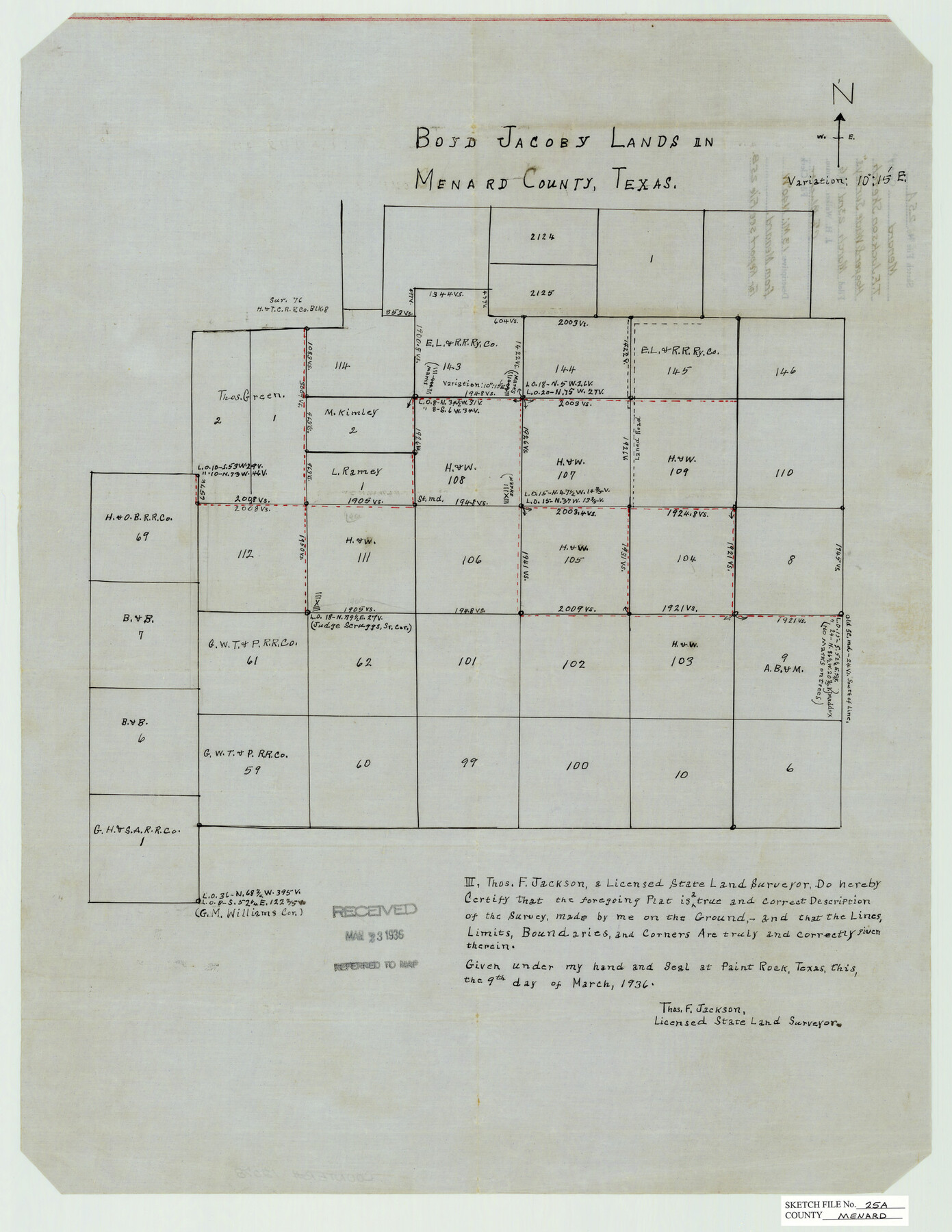
Menard County Sketch File 25A
Boyd Jacoby Lands in Menard County, Texas
-
Map/Doc
12078
-
Collection
General Map Collection
-
Object Dates
3/9/1936 (Creation Date)
3/23/1936 (File Date)
-
People and Organizations
Thomas F. Jackson (Surveyor/Engineer)
-
Counties
Menard Concho
-
Subjects
Surveying Sketch File
-
Height x Width
23.0 x 17.8 inches
58.4 x 45.2 cm
-
Medium
paper, photocopy
-
Comments
See Menard County Sketch File 25b (31557) for report.
Related maps
Menard County Sketch File 25b

Print $6.00
- Digital $50.00
Menard County Sketch File 25b
1936
Size 14.2 x 8.6 inches
Map/Doc 31557
Part of: General Map Collection
Topographical Map of the Rio Grande, Sheet No. 3

Print $20.00
- Digital $50.00
Topographical Map of the Rio Grande, Sheet No. 3
1912
Map/Doc 89527
Smith County Sketch File 9

Print $6.00
- Digital $50.00
Smith County Sketch File 9
1848
Size 16.2 x 10.4 inches
Map/Doc 36763
Montgomery County Working Sketch 64

Print $20.00
- Digital $50.00
Montgomery County Working Sketch 64
1965
Size 27.9 x 33.7 inches
Map/Doc 71171
Harrison County Boundary File 41 (10)

Print $10.00
- Digital $50.00
Harrison County Boundary File 41 (10)
Size 7.1 x 3.4 inches
Map/Doc 54418
[Surveys in Austin's Colony along the Navidad River; John P. Borden for Thos. H. Borden]
![77, [Surveys in Austin's Colony along the Navidad River; John P. Borden for Thos. H. Borden], General Map Collection](https://historictexasmaps.com/wmedia_w700/maps/77.tif.jpg)
Print $20.00
- Digital $50.00
[Surveys in Austin's Colony along the Navidad River; John P. Borden for Thos. H. Borden]
1831
Size 20.6 x 9.3 inches
Map/Doc 77
Bandera County Working Sketch 16a

Print $20.00
- Digital $50.00
Bandera County Working Sketch 16a
1941
Size 12.8 x 22.1 inches
Map/Doc 67609
Hale County Sketch File 20

Print $6.00
- Digital $50.00
Hale County Sketch File 20
Size 15.7 x 10.5 inches
Map/Doc 24753
Dimmit County Working Sketch 54

Print $20.00
- Digital $50.00
Dimmit County Working Sketch 54
1996
Size 27.8 x 30.0 inches
Map/Doc 68715
Tyler County Sketch File 2

Print $4.00
- Digital $50.00
Tyler County Sketch File 2
Size 6.3 x 5.6 inches
Map/Doc 38615
Little River, Faubion Bridge Sheet

Print $4.00
- Digital $50.00
Little River, Faubion Bridge Sheet
1914
Size 19.0 x 27.8 inches
Map/Doc 65060
Hunt County Sketch File 49

Print $4.00
- Digital $50.00
Hunt County Sketch File 49
1852
Size 7.3 x 8.9 inches
Map/Doc 27168
Texas, San Antonio Bay, Panther Point

Print $40.00
- Digital $50.00
Texas, San Antonio Bay, Panther Point
1934
Size 33.2 x 48.3 inches
Map/Doc 69995
You may also like

Flight Mission No. DAG-23K, Frame 144, Matagorda County

Print $20.00
- Digital $50.00
Flight Mission No. DAG-23K, Frame 144, Matagorda County
1953
Size 17.4 x 22.6 inches
Map/Doc 86492
Matagorda County Sketch File 3

Print $4.00
- Digital $50.00
Matagorda County Sketch File 3
1876
Size 12.9 x 8.0 inches
Map/Doc 30732
Foard County Sketch File 30

Print $6.00
- Digital $50.00
Foard County Sketch File 30
Size 9.1 x 8.2 inches
Map/Doc 22858
Nautical Chart 885-SC Intracoastal Waterway - Ellender to Galveston Bay, Louisiana-Texas

Print $20.00
- Digital $50.00
Nautical Chart 885-SC Intracoastal Waterway - Ellender to Galveston Bay, Louisiana-Texas
1972
Size 15.9 x 26.8 inches
Map/Doc 75910
Reeves County Rolled Sketch 2

Print $20.00
- Digital $50.00
Reeves County Rolled Sketch 2
1890
Size 34.0 x 39.5 inches
Map/Doc 9845
Gillespie County

Print $20.00
- Digital $50.00
Gillespie County
1945
Size 36.7 x 45.6 inches
Map/Doc 77289
Sutton County Boundary File 5

Print $28.00
- Digital $50.00
Sutton County Boundary File 5
Size 14.2 x 8.7 inches
Map/Doc 59046
Presidio County Sketch File 49

Print $6.00
- Digital $50.00
Presidio County Sketch File 49
1919
Size 14.6 x 11.9 inches
Map/Doc 34584
Morris County Rolled Sketch 2A

Print $20.00
- Digital $50.00
Morris County Rolled Sketch 2A
Size 24.4 x 19.3 inches
Map/Doc 10266
Reeves County Working Sketch 1

Print $40.00
- Digital $50.00
Reeves County Working Sketch 1
Size 48.6 x 38.2 inches
Map/Doc 63443
Rusk County Working Sketch 29b

Print $20.00
- Digital $50.00
Rusk County Working Sketch 29b
Size 25.8 x 18.1 inches
Map/Doc 63666