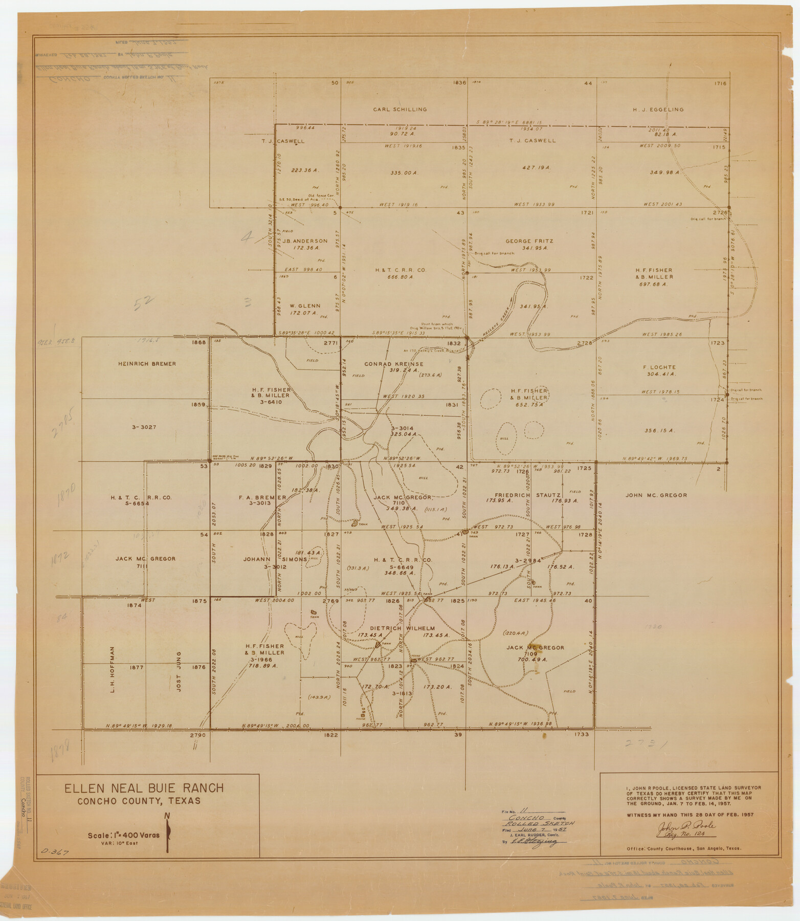
Concho County Rolled Sketch 11
Ellen Neal Buie Ranch, Concho County, Texas
-
Map/Doc
5569
-
Collection
General Map Collection
-
Object Dates
1957/2/28 (Creation Date)
1957/6/7 (File Date)
-
People and Organizations
John P. Poole (Surveyor/Engineer)
-
Counties
Concho
-
Subjects
Surveying Rolled Sketch
-
Height x Width
29.5 x 34.5 inches
74.9 x 87.6 cm
-
Medium
van dyke/brownline/sepia
-
Scale
1" = 400 varas
Part of: General Map Collection
Galveston County Rolled Sketch 39

Print $20.00
- Digital $50.00
Galveston County Rolled Sketch 39
Size 18.1 x 21.5 inches
Map/Doc 45207
Duval County Rolled Sketch 40

Print $20.00
- Digital $50.00
Duval County Rolled Sketch 40
1958
Size 22.8 x 31.1 inches
Map/Doc 5757
Edwards County Working Sketch 126

Print $20.00
- Digital $50.00
Edwards County Working Sketch 126
1980
Size 33.5 x 47.0 inches
Map/Doc 69002
Liberty County Working Sketch 49b

Print $20.00
- Digital $50.00
Liberty County Working Sketch 49b
1955
Size 28.0 x 31.0 inches
Map/Doc 70509
Parker County Working Sketch 4

Print $20.00
- Digital $50.00
Parker County Working Sketch 4
1941
Map/Doc 71454
Gillespie County Rolled Sketch 1

Print $20.00
- Digital $50.00
Gillespie County Rolled Sketch 1
1956
Size 19.7 x 36.1 inches
Map/Doc 6008
Comal County Working Sketch 3

Print $20.00
- Digital $50.00
Comal County Working Sketch 3
1944
Size 31.1 x 27.9 inches
Map/Doc 68169
Calhoun County Sketch File 2

Print $40.00
- Digital $50.00
Calhoun County Sketch File 2
1856
Size 20.2 x 15.8 inches
Map/Doc 11032
Fort Bend County Working Sketch 19

Print $20.00
- Digital $50.00
Fort Bend County Working Sketch 19
1959
Size 26.3 x 29.9 inches
Map/Doc 69225
Galveston County Sketch File 43

Print $40.00
- Digital $50.00
Galveston County Sketch File 43
1915
Size 19.4 x 15.1 inches
Map/Doc 11539
Galveston County NRC Article 33.136 Sketch 62

Print $28.00
- Digital $50.00
Galveston County NRC Article 33.136 Sketch 62
2009
Size 24.0 x 36.0 inches
Map/Doc 94596
Wichita County Working Sketch 16

Print $20.00
- Digital $50.00
Wichita County Working Sketch 16
1939
Size 21.4 x 34.7 inches
Map/Doc 72526
You may also like
Webb County Rolled Sketch 62

Print $20.00
- Digital $50.00
Webb County Rolled Sketch 62
1947
Size 25.2 x 27.4 inches
Map/Doc 8212
[Township 3 North, Block 33]
![91215, [Township 3 North, Block 33], Twichell Survey Records](https://historictexasmaps.com/wmedia_w700/maps/91215-1.tif.jpg)
Print $3.00
- Digital $50.00
[Township 3 North, Block 33]
Size 11.2 x 17.0 inches
Map/Doc 91215
Flight Mission No. DQO-12K, Frame 38, Galveston County

Print $20.00
- Digital $50.00
Flight Mission No. DQO-12K, Frame 38, Galveston County
1952
Size 18.8 x 22.5 inches
Map/Doc 85229
Crockett County Sketch File 60

Print $22.00
- Digital $50.00
Crockett County Sketch File 60
1925
Size 11.4 x 8.7 inches
Map/Doc 19837
Newton County Working Sketch 39

Print $20.00
- Digital $50.00
Newton County Working Sketch 39
1961
Size 36.6 x 41.0 inches
Map/Doc 71285
Brazoria County Working Sketch Graphic Index

Print $20.00
- Digital $50.00
Brazoria County Working Sketch Graphic Index
1947
Size 41.0 x 38.1 inches
Map/Doc 76471
Dimmit County Working Sketch 42

Print $20.00
- Digital $50.00
Dimmit County Working Sketch 42
1977
Size 33.5 x 39.6 inches
Map/Doc 68703
Mitchell County Sketch File 2

Print $22.00
- Digital $50.00
Mitchell County Sketch File 2
Size 9.1 x 14.0 inches
Map/Doc 31688
Sketch of Block A7, Hartley County, Texas

Print $20.00
- Digital $50.00
Sketch of Block A7, Hartley County, Texas
1905
Size 10.2 x 22.1 inches
Map/Doc 90756
Borden County Boundary File 6

Print $28.00
- Digital $50.00
Borden County Boundary File 6
1908
Size 11.3 x 25.1 inches
Map/Doc 1717
Louisiana and Texas Intracoastal Waterway, Section 7, Galveston Bay to Brazos River and Section 8, Brazos River to Matagorda Bay

Print $20.00
- Digital $50.00
Louisiana and Texas Intracoastal Waterway, Section 7, Galveston Bay to Brazos River and Section 8, Brazos River to Matagorda Bay
1937
Size 30.7 x 42.7 inches
Map/Doc 73064
San Patricio County, Texas

Print $20.00
- Digital $50.00
San Patricio County, Texas
1879
Size 18.1 x 22.8 inches
Map/Doc 611