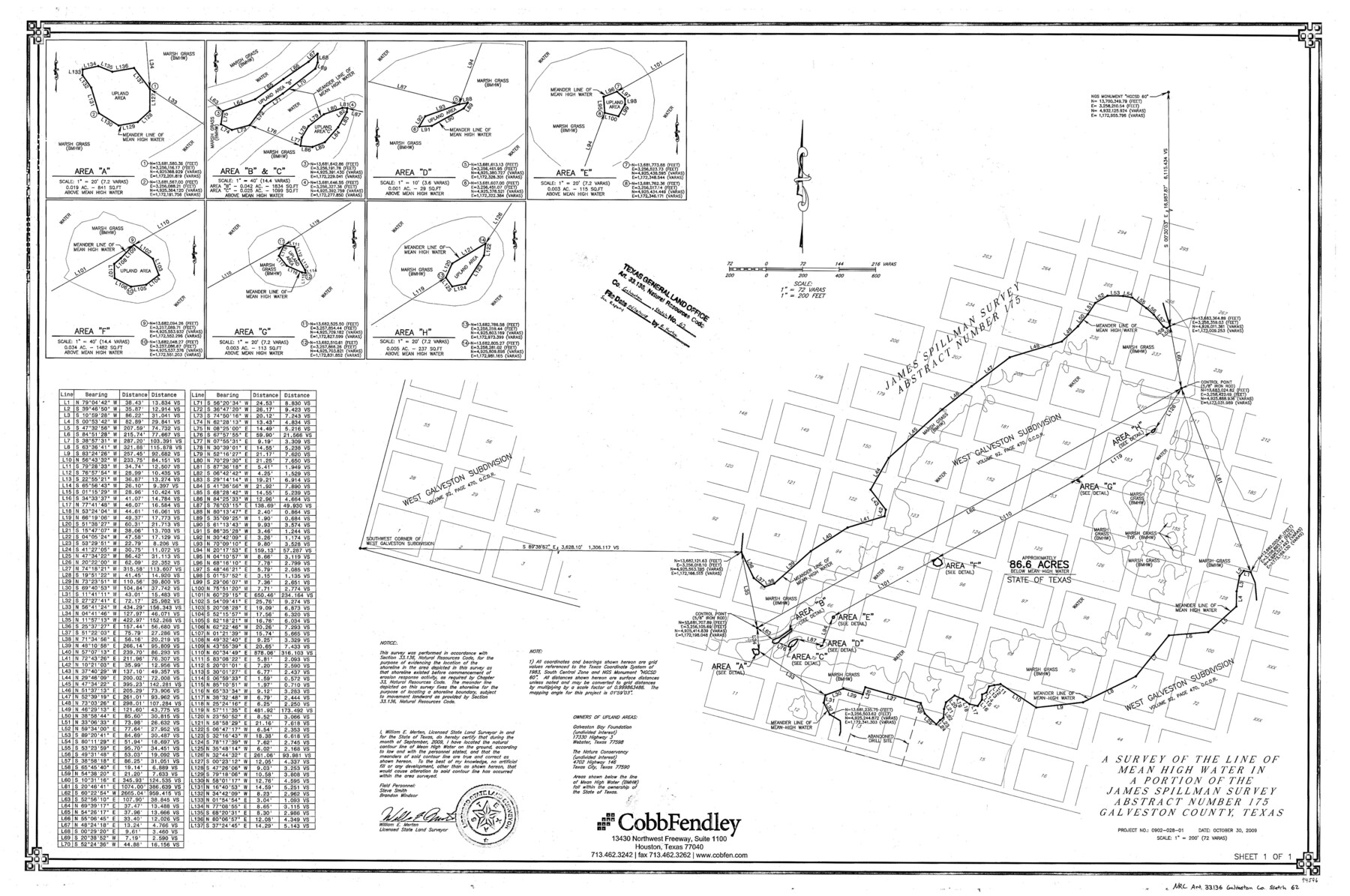
Galveston County NRC Article 33.136 Sketch 62
A survey of the line of mean high water in a portion of the James Spillman survey abstract number 175
-
Map/Doc
94596
-
Collection
General Map Collection
-
Object Dates
2009/10/30 (Creation Date)
2018/6/18 (File Date)
-
People and Organizations
William E. Merten (Surveyor/Engineer)
-
Counties
Galveston
-
Subjects
Surveying CBS
-
Height x Width
24.0 x 36.0 inches
61.0 x 91.4 cm
-
Medium
multi-page, multi-format
-
Scale
1" = 200'
-
Comments
Project: Pierce Marsh-2009 Project No.: CL960007 (GLO)
Part of: General Map Collection
Lee County Working Sketch 11

Print $20.00
- Digital $50.00
Lee County Working Sketch 11
1980
Size 25.2 x 25.7 inches
Map/Doc 70390
Bandera County Working Sketch 23

Print $20.00
- Digital $50.00
Bandera County Working Sketch 23
1950
Size 35.8 x 29.6 inches
Map/Doc 67619
Donley County Sketch File 27

Print $4.00
- Digital $50.00
Donley County Sketch File 27
Size 7.7 x 12.1 inches
Map/Doc 21264
Brewster County Working Sketch 104

Print $20.00
- Digital $50.00
Brewster County Working Sketch 104
1980
Size 30.6 x 46.0 inches
Map/Doc 67704
Lynn County Rolled Sketch 5

Print $20.00
- Digital $50.00
Lynn County Rolled Sketch 5
1912
Size 17.1 x 26.4 inches
Map/Doc 6645
Brazos River, Brazos River Sheet 1

Print $20.00
- Digital $50.00
Brazos River, Brazos River Sheet 1
1926
Size 20.6 x 24.6 inches
Map/Doc 78264
Duval County Sketch File 4c1

Print $4.00
- Digital $50.00
Duval County Sketch File 4c1
1874
Size 10.4 x 7.9 inches
Map/Doc 21286
Polk County Sketch File 18

Print $20.00
- Digital $50.00
Polk County Sketch File 18
1862
Size 25.5 x 18.9 inches
Map/Doc 12190
Williamson County Working Sketch 3

Print $20.00
- Digital $50.00
Williamson County Working Sketch 3
1915
Size 17.9 x 20.2 inches
Map/Doc 72563
Pecos County Sketch File 30

Print $20.00
- Digital $50.00
Pecos County Sketch File 30
Size 28.9 x 22.0 inches
Map/Doc 12172
Fort Bend County Sketch File 3

Print $4.00
- Digital $50.00
Fort Bend County Sketch File 3
Size 12.8 x 8.1 inches
Map/Doc 22880
Briscoe County Boundary File 7

Print $6.00
- Digital $50.00
Briscoe County Boundary File 7
Size 10.6 x 8.1 inches
Map/Doc 50806
You may also like
Boundary Line Between Texas and New Mexico, Supreme Court Decision - Oct. Term, 1930

Print $304.00
Boundary Line Between Texas and New Mexico, Supreme Court Decision - Oct. Term, 1930
1930
Map/Doc 81688
United States - Gulf Coast - From Latitude 26° 33' to the Rio Grande Texas

Print $20.00
- Digital $50.00
United States - Gulf Coast - From Latitude 26° 33' to the Rio Grande Texas
1916
Size 27.8 x 18.3 inches
Map/Doc 72839
State Land For Sale On Mustang Island by General Land Office

Print $20.00
- Digital $50.00
State Land For Sale On Mustang Island by General Land Office
1910
Size 21.7 x 17.5 inches
Map/Doc 385
[Surveys along the boundary between Jasper and Jefferson Counties]
![99, [Surveys along the boundary between Jasper and Jefferson Counties], General Map Collection](https://historictexasmaps.com/wmedia_w700/maps/99.tif.jpg)
Print $3.00
- Digital $50.00
[Surveys along the boundary between Jasper and Jefferson Counties]
1841
Size 9.3 x 16.9 inches
Map/Doc 99
[John B. Robinson and surrounding surveys]
![91040, [John B. Robinson and surrounding surveys], Twichell Survey Records](https://historictexasmaps.com/wmedia_w700/maps/91040-1.tif.jpg)
Print $20.00
- Digital $50.00
[John B. Robinson and surrounding surveys]
Size 12.9 x 15.2 inches
Map/Doc 91040
Bee County Working Sketch 18

Print $20.00
- Digital $50.00
Bee County Working Sketch 18
1980
Size 19.5 x 18.5 inches
Map/Doc 67268
Kimble County Working Sketch 26

Print $20.00
- Digital $50.00
Kimble County Working Sketch 26
1934
Size 24.3 x 18.4 inches
Map/Doc 70094
Houston Ship Channel, Atkinson Island to Alexander Island

Print $40.00
- Digital $50.00
Houston Ship Channel, Atkinson Island to Alexander Island
1972
Size 36.9 x 50.0 inches
Map/Doc 69901
A Map of the United States of Mexico as organized and defined by the several Acts of the Congress of that Republic

Print $20.00
- Digital $50.00
A Map of the United States of Mexico as organized and defined by the several Acts of the Congress of that Republic
1826
Size 23.9 x 31.2 inches
Map/Doc 93939
Val Verde County Working Sketch 38

Print $20.00
- Digital $50.00
Val Verde County Working Sketch 38
1943
Size 14.8 x 18.9 inches
Map/Doc 72173
Concho County Sketch File 45

Print $6.00
- Digital $50.00
Concho County Sketch File 45
1958
Size 11.2 x 8.8 inches
Map/Doc 19210
Van Zandt County Working Sketch 8

Print $3.00
- Digital $50.00
Van Zandt County Working Sketch 8
1982
Size 15.6 x 9.2 inches
Map/Doc 72258