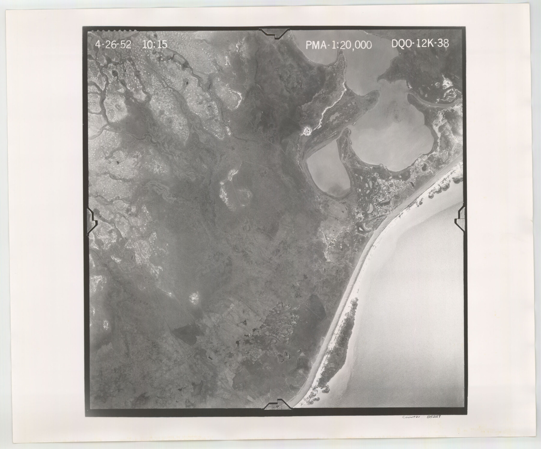
Flight Mission No. DQO-12K, Frame 38, Galveston County
DQO-12K-38
-
Map/Doc
85229
-
Collection
General Map Collection
-
Object Dates
1952/4/26 (Creation Date)
-
People and Organizations
U. S. Department of Agriculture (Publisher)
-
Counties
Galveston
-
Subjects
Aerial Photograph
-
Height x Width
18.8 x 22.5 inches
47.8 x 57.2 cm
-
Comments
Flown by Aero Exploration Company of Tulsa, Oklahoma.
Part of: General Map Collection
Hydograhic Survey H-994, Corpus Christi Pass

Print $40.00
- Digital $50.00
Hydograhic Survey H-994, Corpus Christi Pass
1869
Size 31.8 x 53.7 inches
Map/Doc 2701
Fisher County Sketch File Bb

Print $26.00
- Digital $50.00
Fisher County Sketch File Bb
1902
Size 14.3 x 8.7 inches
Map/Doc 22657
Flight Mission No. CLL-3N, Frame 20, Willacy County

Print $20.00
- Digital $50.00
Flight Mission No. CLL-3N, Frame 20, Willacy County
1954
Size 18.5 x 22.1 inches
Map/Doc 87086
Galveston County NRC Article 33.136 Sketch 64

Print $26.00
- Digital $50.00
Galveston County NRC Article 33.136 Sketch 64
2010
Size 24.0 x 36.0 inches
Map/Doc 89990
Swisher County Sketch File 2

Print $8.00
- Digital $50.00
Swisher County Sketch File 2
1891
Size 14.3 x 8.6 inches
Map/Doc 37574
Old Miscellaneous File 6

Print $4.00
- Digital $50.00
Old Miscellaneous File 6
1847
Size 4.2 x 7.6 inches
Map/Doc 75420
[San Patricio No. 2]
![69746, [San Patricio No. 2], General Map Collection](https://historictexasmaps.com/wmedia_w700/maps/69746.tif.jpg)
Print $2.00
- Digital $50.00
[San Patricio No. 2]
1847
Size 8.3 x 11.2 inches
Map/Doc 69746
Rusk County Sketch File 20

Print $4.00
Rusk County Sketch File 20
1859
Size 10.2 x 8.1 inches
Map/Doc 35530
Flight Mission No. DAG-21K, Frame 110, Matagorda County

Print $20.00
- Digital $50.00
Flight Mission No. DAG-21K, Frame 110, Matagorda County
1952
Size 18.6 x 22.6 inches
Map/Doc 86438
Brewster County Rolled Sketch 109

Print $20.00
- Digital $50.00
Brewster County Rolled Sketch 109
1961
Size 19.3 x 25.3 inches
Map/Doc 5261
Brewster County Sketch File S-2

Print $16.00
- Digital $50.00
Brewster County Sketch File S-2
1910
Size 17.0 x 11.0 inches
Map/Doc 15731
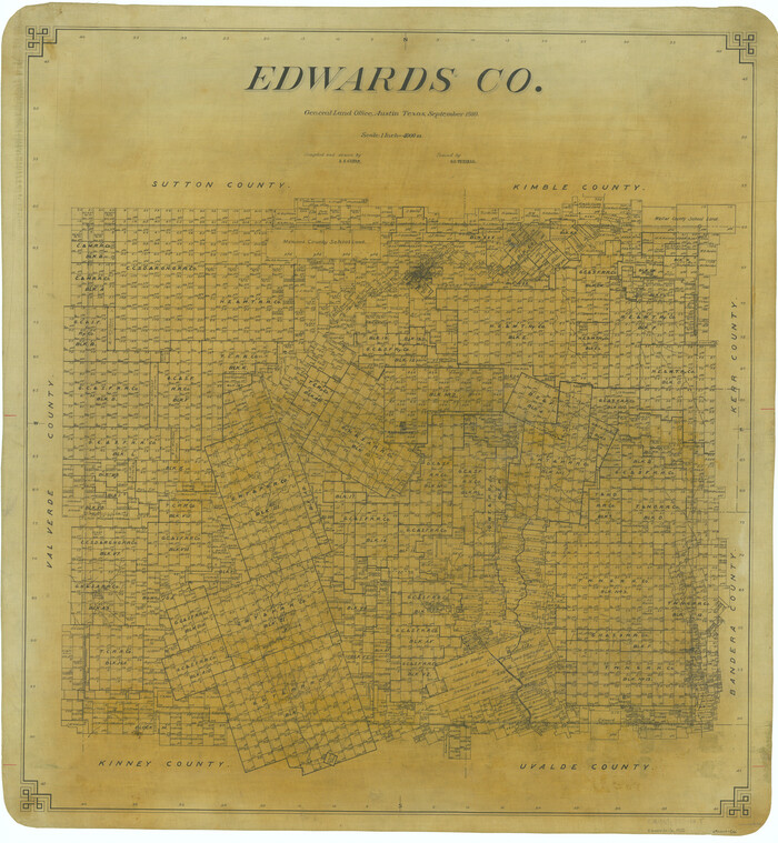
Edwards County Working Sketch 120

Print $40.00
- Digital $50.00
Edwards County Working Sketch 120
1975
Size 25.0 x 48.9 inches
Map/Doc 68996
You may also like
Floyd County Sketch File 32a

Print $20.00
- Digital $50.00
Floyd County Sketch File 32a
1952
Size 36.5 x 33.1 inches
Map/Doc 10451
Tyler County Sketch File 24

Print $16.00
- Digital $50.00
Tyler County Sketch File 24
1944
Size 11.2 x 9.0 inches
Map/Doc 38681
The Republic County of Brazoria. December 16, 1839

Print $20.00
The Republic County of Brazoria. December 16, 1839
2020
Size 14.7 x 21.8 inches
Map/Doc 96113
Llano County Sketch File 5

Print $4.00
- Digital $50.00
Llano County Sketch File 5
Size 12.7 x 8.2 inches
Map/Doc 30356
[Surveys in McMullen and McGloin's Colony along the San Antonio River]
![30, [Surveys in McMullen and McGloin's Colony along the San Antonio River], General Map Collection](https://historictexasmaps.com/wmedia_w700/maps/30-1.tif.jpg)
Print $20.00
- Digital $50.00
[Surveys in McMullen and McGloin's Colony along the San Antonio River]
1828
Size 19.3 x 24.5 inches
Map/Doc 30
Scurry County Rolled Sketch 2

Print $20.00
- Digital $50.00
Scurry County Rolled Sketch 2
Size 44.0 x 44.9 inches
Map/Doc 9911
Topographic Map of Big Bend Area

Print $20.00
Topographic Map of Big Bend Area
1923
Size 47.1 x 35.0 inches
Map/Doc 79757
San Augustine County Sketch File 9

Print $4.00
San Augustine County Sketch File 9
1860
Size 12.6 x 7.6 inches
Map/Doc 35650

Hockley County

Print $20.00
- Digital $50.00
Hockley County
1954
Size 41.0 x 36.4 inches
Map/Doc 77313
Knox County Working Sketch 18

Print $20.00
- Digital $50.00
Knox County Working Sketch 18
1988
Size 40.0 x 29.7 inches
Map/Doc 70260