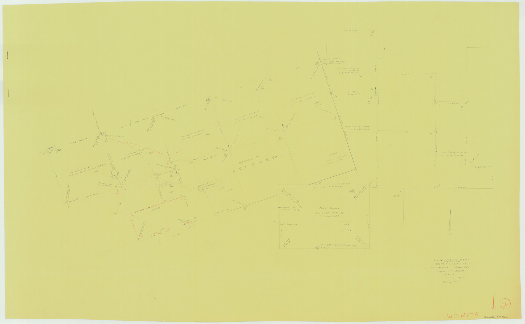
Wichita County Working Sketch 16
-
Map/Doc
72526
-
Collection
General Map Collection
-
Object Dates
8/4/1939 (Creation Date)
-
People and Organizations
Herbert de Synek (Draftsman)
-
Counties
Wichita
-
Subjects
Surveying Working Sketch
-
Height x Width
21.4 x 34.7 inches
54.4 x 88.1 cm
-
Scale
1" = 500 varas
Part of: General Map Collection
Brazos River, Clemens State Farm Sheet

Print $20.00
- Digital $50.00
Brazos River, Clemens State Farm Sheet
1915
Size 37.5 x 34.6 inches
Map/Doc 69673
Nueces County Sketch File 39

Print $8.00
- Digital $50.00
Nueces County Sketch File 39
1934
Size 11.0 x 8.5 inches
Map/Doc 32623
Flight Mission No. CRC-2R, Frame 195, Chambers County

Print $20.00
- Digital $50.00
Flight Mission No. CRC-2R, Frame 195, Chambers County
1956
Size 18.6 x 22.3 inches
Map/Doc 84773
Medina County Working Sketch 5

Print $20.00
- Digital $50.00
Medina County Working Sketch 5
1949
Size 38.5 x 37.3 inches
Map/Doc 70920
Starr County Rolled Sketch 19

Print $20.00
- Digital $50.00
Starr County Rolled Sketch 19
1920
Size 20.8 x 24.9 inches
Map/Doc 7803
Rusk County Working Sketch 5

Print $20.00
- Digital $50.00
Rusk County Working Sketch 5
1983
Size 33.1 x 25.7 inches
Map/Doc 63640
Presidio County Working Sketch 14

Print $20.00
- Digital $50.00
Presidio County Working Sketch 14
1942
Size 10.9 x 17.7 inches
Map/Doc 71690
Randall County

Print $20.00
- Digital $50.00
Randall County
1879
Size 21.4 x 19.2 inches
Map/Doc 3974
Runnels County Sketch File 38

Print $20.00
Runnels County Sketch File 38
1891
Size 17.6 x 24.9 inches
Map/Doc 12269
Red River County Working Sketch 22

Print $20.00
- Digital $50.00
Red River County Working Sketch 22
1955
Size 27.9 x 26.8 inches
Map/Doc 72005
Old Miscellaneous File 4

Print $22.00
- Digital $50.00
Old Miscellaneous File 4
1845
Size 16.5 x 20.8 inches
Map/Doc 75416
[The S.K. Ry. of Texas, State Line to Pecos, Reeves Co., Texas]
![64163, [The S.K. Ry. of Texas, State Line to Pecos, Reeves Co., Texas], General Map Collection](https://historictexasmaps.com/wmedia_w700/maps/64163.tif.jpg)
Print $40.00
- Digital $50.00
[The S.K. Ry. of Texas, State Line to Pecos, Reeves Co., Texas]
1910
Size 19.3 x 120.2 inches
Map/Doc 64163
You may also like
Crockett County Sketch File 51a

Print $10.00
- Digital $50.00
Crockett County Sketch File 51a
1922
Size 14.3 x 8.8 inches
Map/Doc 19812
Kent County Boundary File 7

Print $6.00
- Digital $50.00
Kent County Boundary File 7
Size 10.8 x 8.7 inches
Map/Doc 55870
Haskell County Rolled Sketch 6

Print $20.00
- Digital $50.00
Haskell County Rolled Sketch 6
1940
Size 22.3 x 19.6 inches
Map/Doc 6166
Atascosa County Working Sketch 29

Print $20.00
- Digital $50.00
Atascosa County Working Sketch 29
1977
Size 16.8 x 15.1 inches
Map/Doc 67225
Terrell County Rolled Sketch 26

Print $20.00
- Digital $50.00
Terrell County Rolled Sketch 26
1914
Size 17.3 x 15.2 inches
Map/Doc 7933
Edwards County Sketch File 19

Print $20.00
- Digital $50.00
Edwards County Sketch File 19
Size 17.1 x 23.7 inches
Map/Doc 11430
General Highway Map, Brewster County, Texas

Print $20.00
General Highway Map, Brewster County, Texas
1961
Size 18.3 x 24.9 inches
Map/Doc 79386
Presidio County Sketch File 11

Print $20.00
- Digital $50.00
Presidio County Sketch File 11
1882
Size 18.0 x 25.0 inches
Map/Doc 11706
Floyd County Boundary File 1

Print $30.00
- Digital $50.00
Floyd County Boundary File 1
Size 8.9 x 4.2 inches
Map/Doc 53445
Titus County Boundary File 29

Print $72.00
- Digital $50.00
Titus County Boundary File 29
Size 9.0 x 4.1 inches
Map/Doc 59311
Jefferson County Rolled Sketch 49

Print $40.00
- Digital $50.00
Jefferson County Rolled Sketch 49
1963
Size 32.5 x 57.4 inches
Map/Doc 66844
General Highway Map, Jasper County, Texas

Print $20.00
General Highway Map, Jasper County, Texas
1961
Size 18.2 x 24.8 inches
Map/Doc 79534