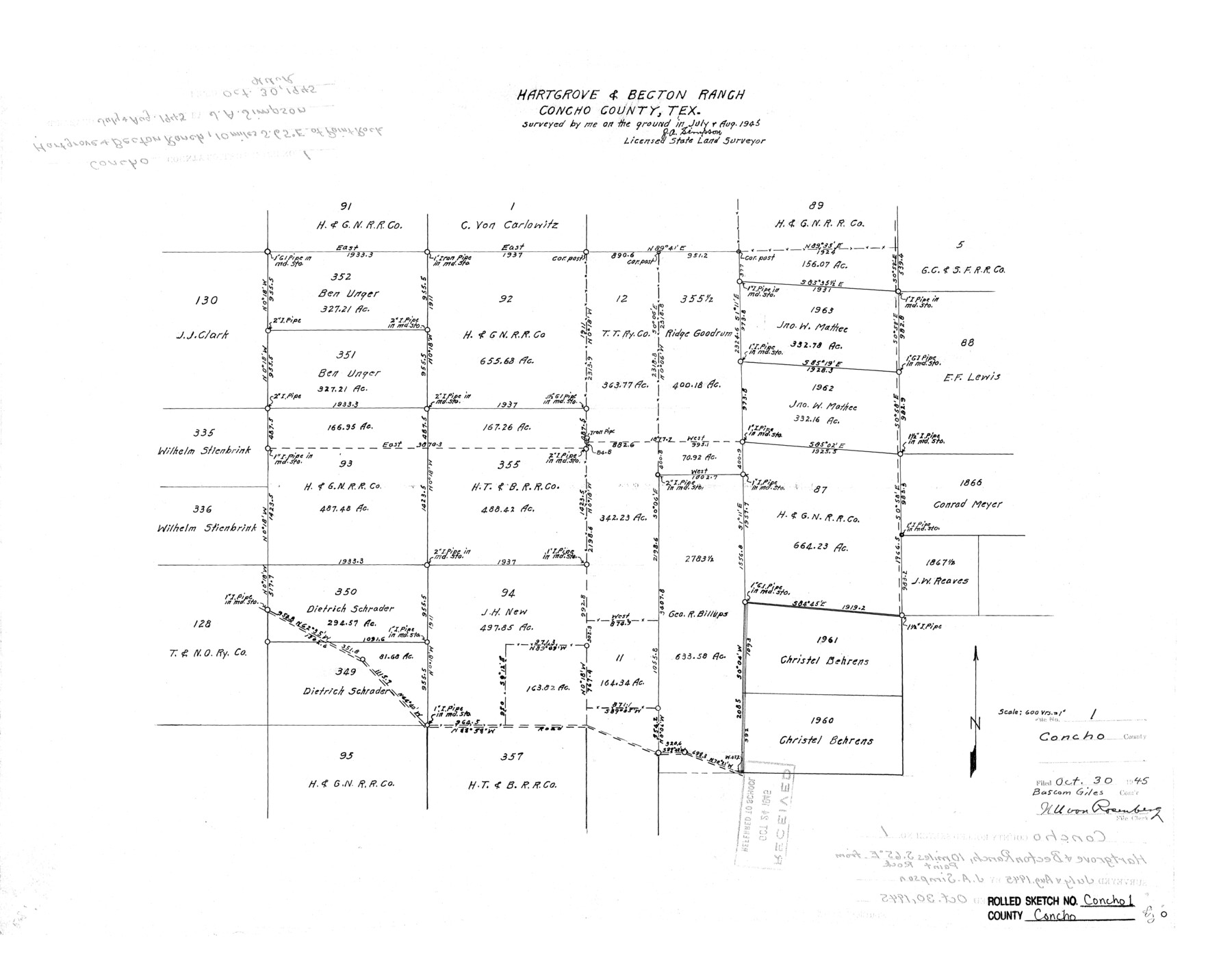
Concho County Rolled Sketch 1
Hartgrove & Becton Ranch, Concho County, Tex.
-
Map/Doc
5543
-
Collection
General Map Collection
-
Object Dates
1945 (Creation Date)
1945/10/30 (File Date)
-
People and Organizations
J.A. Simpson (Surveyor/Engineer)
-
Counties
Concho
-
Subjects
Surveying Rolled Sketch
-
Height x Width
19.5 x 25.0 inches
49.5 x 63.5 cm
-
Scale
1" = 600 varas
Part of: General Map Collection
Map of the Fort Worth & Denver City Railway

Print $20.00
- Digital $50.00
Map of the Fort Worth & Denver City Railway
1887
Size 19.3 x 15.1 inches
Map/Doc 64434
Delta County Sketch File 6

Print $20.00
- Digital $50.00
Delta County Sketch File 6
Size 18.3 x 22.4 inches
Map/Doc 11310
Nueces County Sketch File 54

Print $4.00
- Digital $50.00
Nueces County Sketch File 54
1856
Size 12.7 x 8.1 inches
Map/Doc 32865
Flight Mission No. DQN-5K, Frame 29, Calhoun County

Print $20.00
- Digital $50.00
Flight Mission No. DQN-5K, Frame 29, Calhoun County
1953
Size 18.5 x 22.3 inches
Map/Doc 84380
Right of Way and Track Map - Houston & Texas Central R.R. operated by the T. and N. O. R.R. Co. - Main Line

Print $40.00
- Digital $50.00
Right of Way and Track Map - Houston & Texas Central R.R. operated by the T. and N. O. R.R. Co. - Main Line
1918
Size 25.2 x 57.8 inches
Map/Doc 82859
Irion County Sketch File 1

Print $20.00
- Digital $50.00
Irion County Sketch File 1
1881
Size 43.9 x 18.3 inches
Map/Doc 10615
Right of Way and Track Map, Galveston, Harrisburg & San Antonio Ry. operated by the T. & N. O. R.R. Co., Victoria Division, Rosenberg to Beeville

Print $40.00
- Digital $50.00
Right of Way and Track Map, Galveston, Harrisburg & San Antonio Ry. operated by the T. & N. O. R.R. Co., Victoria Division, Rosenberg to Beeville
Size 24.3 x 55.8 inches
Map/Doc 76162
United States - Gulf Coast Texas - Southern part of Laguna Madre

Print $20.00
- Digital $50.00
United States - Gulf Coast Texas - Southern part of Laguna Madre
1941
Size 26.4 x 18.2 inches
Map/Doc 72956
Wheeler County

Print $20.00
- Digital $50.00
Wheeler County
1899
Size 44.2 x 38.7 inches
Map/Doc 63121
Kimble County

Print $40.00
- Digital $50.00
Kimble County
1930
Size 41.0 x 49.0 inches
Map/Doc 77340
Rockwall County Boundary File 52a

Print $22.00
- Digital $50.00
Rockwall County Boundary File 52a
Size 12.9 x 8.3 inches
Map/Doc 58461
Hardin County

Print $20.00
- Digital $50.00
Hardin County
1940
Size 40.7 x 37.7 inches
Map/Doc 77303
You may also like
Kleberg County Rolled Sketch 8

Print $20.00
- Digital $50.00
Kleberg County Rolled Sketch 8
1947
Size 33.0 x 42.0 inches
Map/Doc 9360
Flight Mission No. DQN-2K, Frame 42, Calhoun County

Print $20.00
- Digital $50.00
Flight Mission No. DQN-2K, Frame 42, Calhoun County
1953
Size 18.5 x 22.2 inches
Map/Doc 84247
Flight Mission No. BRE-2P, Frame 42, Nueces County

Print $20.00
- Digital $50.00
Flight Mission No. BRE-2P, Frame 42, Nueces County
1956
Size 18.5 x 22.4 inches
Map/Doc 86744
Jefferson County Rolled Sketch 18

Print $40.00
- Digital $50.00
Jefferson County Rolled Sketch 18
1931
Size 19.1 x 72.8 inches
Map/Doc 9282
Austin County Sketch File 10

Print $40.00
- Digital $50.00
Austin County Sketch File 10
1895
Size 25.5 x 21.0 inches
Map/Doc 10875
Map of Eastland County

Print $20.00
- Digital $50.00
Map of Eastland County
1877
Size 26.5 x 24.6 inches
Map/Doc 4535
Pecos County Working Sketch 41

Print $20.00
- Digital $50.00
Pecos County Working Sketch 41
1942
Size 19.0 x 31.7 inches
Map/Doc 71513
Val Verde County Working Sketch 58

Print $20.00
- Digital $50.00
Val Verde County Working Sketch 58
1958
Size 21.0 x 22.8 inches
Map/Doc 72193
University Lands Hudspeth County, Texas, Blocks A to N

Print $40.00
- Digital $50.00
University Lands Hudspeth County, Texas, Blocks A to N
1935
Size 38.6 x 55.4 inches
Map/Doc 2447
Washington County Sketch File 7

Print $4.00
- Digital $50.00
Washington County Sketch File 7
1873
Size 12.2 x 7.6 inches
Map/Doc 39654

Smith County Sketch File 4

Print $4.00
- Digital $50.00
Smith County Sketch File 4
1853
Size 10.3 x 8.1 inches
Map/Doc 36752