Austin County Sketch File 10
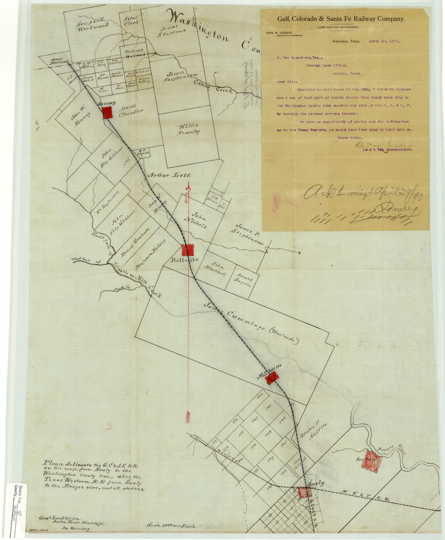
[Map of part of Austin County showing G. C. & S. F. Railroad from Sealy to the Washington County line]
-
Map/Doc
10875
-
Collection
General Map Collection
-
Object Dates
1895/4/26 (Creation Date)
-
Counties
Austin Washington
-
Subjects
Surveying Sketch File
-
Height x Width
25.5 x 21.0 inches
64.8 x 53.3 cm
-
Medium
multi-page, multi-format
-
Scale
1" = 2000 varas
-
Features
Caney Creek
Kenney
Bellville
West Fork of Palmetto or Mill Creek
East Fork of Palmetto or Mill Creek
Sandy Creek
West Fork of Palmetto Creek
West Fork of Mill Creek
East Fork of Palmetto Creek
West Fork of Palmetto Creek
Millheim
San Felipe
Brazos River
MK&T
GC&SF
Part of: General Map Collection
Hardin County Rolled Sketch 17

Print $20.00
- Digital $50.00
Hardin County Rolled Sketch 17
1951
Size 38.3 x 32.4 inches
Map/Doc 6087
Tyler County Working Sketch 3

Print $20.00
- Digital $50.00
Tyler County Working Sketch 3
1922
Size 28.0 x 32.6 inches
Map/Doc 69473
Bee County Sketch File 28

Print $6.00
- Digital $50.00
Bee County Sketch File 28
Size 14.4 x 8.7 inches
Map/Doc 14335
Upton County Rolled Sketch 27

Print $40.00
- Digital $50.00
Upton County Rolled Sketch 27
1945
Size 42.1 x 62.1 inches
Map/Doc 10046
Flight Mission No. BRA-16M, Frame 118, Jefferson County

Print $20.00
- Digital $50.00
Flight Mission No. BRA-16M, Frame 118, Jefferson County
1953
Size 18.6 x 22.1 inches
Map/Doc 85728
Archer County Sketch File 15

Print $40.00
- Digital $50.00
Archer County Sketch File 15
1886
Size 16.6 x 17.9 inches
Map/Doc 10827
Flight Mission No. DIX-10P, Frame 171, Aransas County

Print $20.00
- Digital $50.00
Flight Mission No. DIX-10P, Frame 171, Aransas County
1956
Size 18.8 x 22.3 inches
Map/Doc 83961
Map of Midland County

Print $20.00
- Digital $50.00
Map of Midland County
1901
Size 43.9 x 38.3 inches
Map/Doc 7825
Travis County Appraisal District Plat Map 2_2313

Print $20.00
- Digital $50.00
Travis County Appraisal District Plat Map 2_2313
Size 21.4 x 26.3 inches
Map/Doc 94215
Morris County Working Sketch 4

Print $20.00
- Digital $50.00
Morris County Working Sketch 4
1959
Size 35.2 x 23.8 inches
Map/Doc 71203
Trinity River, Levee Improvement Districts, Widths of Floodways

Print $20.00
- Digital $50.00
Trinity River, Levee Improvement Districts, Widths of Floodways
1923
Size 37.6 x 28.2 inches
Map/Doc 65253
[Map of Sabine County]
![4009, [Map of Sabine County], General Map Collection](https://historictexasmaps.com/wmedia_w700/maps/4009.tif.jpg)
Print $20.00
- Digital $50.00
[Map of Sabine County]
1839
Size 23.9 x 18.9 inches
Map/Doc 4009
You may also like
Hardin County Rolled Sketch 21

Print $20.00
- Digital $50.00
Hardin County Rolled Sketch 21
1966
Size 18.8 x 22.7 inches
Map/Doc 6090
Flight Mission No. DIX-5P, Frame 148, Aransas County

Print $20.00
- Digital $50.00
Flight Mission No. DIX-5P, Frame 148, Aransas County
1956
Size 17.9 x 18.0 inches
Map/Doc 83810
Map of The Surveyed Part of Peters Colony Texas

Print $40.00
- Digital $50.00
Map of The Surveyed Part of Peters Colony Texas
1858
Size 45.6 x 58.5 inches
Map/Doc 1982
Map of lands in King County, Texas owned and leased by the Louisville Land and Cattle Company

Print $20.00
- Digital $50.00
Map of lands in King County, Texas owned and leased by the Louisville Land and Cattle Company
Size 29.1 x 25.1 inches
Map/Doc 717
Trinity River, Trinidad Sheet

Print $20.00
- Digital $50.00
Trinity River, Trinidad Sheet
1928
Size 39.0 x 46.3 inches
Map/Doc 65183
Controlled Mosaic by Jack Amman Photogrammetric Engineers, Inc - Sheet 41

Print $20.00
- Digital $50.00
Controlled Mosaic by Jack Amman Photogrammetric Engineers, Inc - Sheet 41
1954
Size 20.0 x 24.0 inches
Map/Doc 83498
Val Verde County Working Sketch 12

Print $20.00
- Digital $50.00
Val Verde County Working Sketch 12
1920
Size 29.0 x 24.3 inches
Map/Doc 72147
Lampasas County Boundary File 1

Print $4.00
- Digital $50.00
Lampasas County Boundary File 1
Size 10.2 x 8.2 inches
Map/Doc 56093
Hudspeth County Sketch File 43

Print $10.00
- Digital $50.00
Hudspeth County Sketch File 43
1982
Size 14.3 x 8.9 inches
Map/Doc 27022
Map of Briscoe County, Texas

Print $20.00
- Digital $50.00
Map of Briscoe County, Texas
1879
Size 22.6 x 18.0 inches
Map/Doc 614
Edwards County Working Sketch 133

Print $20.00
- Digital $50.00
Edwards County Working Sketch 133
1985
Size 29.7 x 38.9 inches
Map/Doc 69009
Midland County Working Sketch 15

Print $20.00
- Digital $50.00
Midland County Working Sketch 15
1953
Size 27.2 x 28.6 inches
Map/Doc 70995