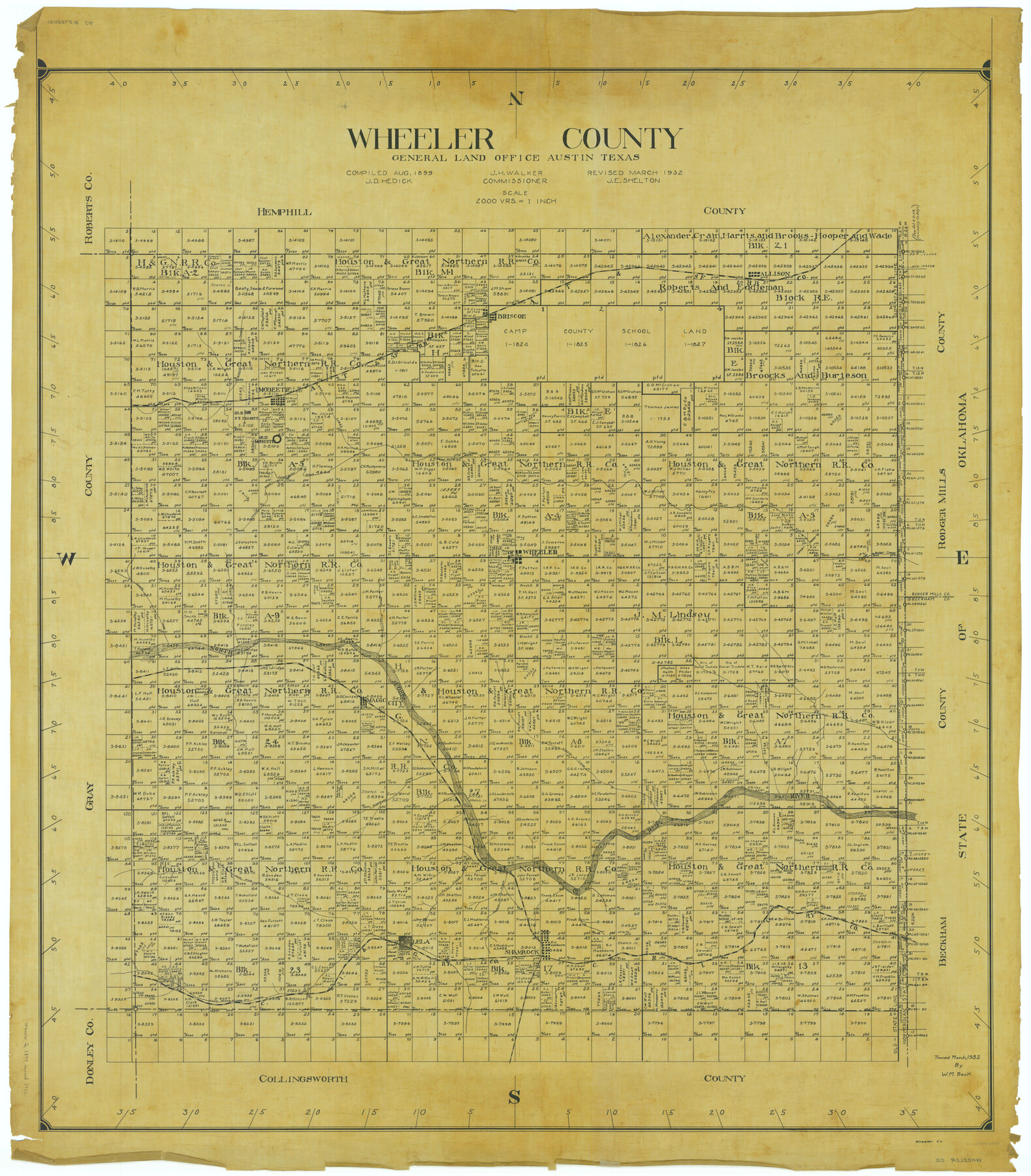
Wheeler County
-
Map/Doc
63121
-
Collection
General Map Collection
-
Object Dates
1899 (Creation Date)
-
People and Organizations
Texas General Land Office (Publisher)
John D. Hedick (Compiler)
J.H. Walker (GLO Commissioner)
-
Counties
Wheeler
-
Subjects
County
-
Height x Width
44.2 x 38.7 inches
112.3 x 98.3 cm
-
Comments
Revised in March 1932 by J. E. Shelton.
Traced in March 1932 by W. M. Beck.
Part of: General Map Collection
Harris County

Print $40.00
- Digital $50.00
Harris County
1896
Size 44.4 x 69.3 inches
Map/Doc 66857
Mills County Boundary File 1

Print $28.00
- Digital $50.00
Mills County Boundary File 1
Size 8.3 x 8.0 inches
Map/Doc 57259
Terrell County Rolled Sketch 52

Print $20.00
- Digital $50.00
Terrell County Rolled Sketch 52
1967
Size 26.8 x 30.5 inches
Map/Doc 7970
Nueces County Sketch File 85

Print $2.00
- Digital $50.00
Nueces County Sketch File 85
Size 11.0 x 8.5 inches
Map/Doc 82922
Webb County Working Sketch 31

Print $20.00
- Digital $50.00
Webb County Working Sketch 31
1937
Size 23.2 x 26.0 inches
Map/Doc 72396
Gregg County Working Sketch 7

Print $20.00
- Digital $50.00
Gregg County Working Sketch 7
1934
Size 32.2 x 21.0 inches
Map/Doc 63273
[Sketch for Mineral Application 24072, San Jacinto River]
![65602, [Sketch for Mineral Application 24072, San Jacinto River], General Map Collection](https://historictexasmaps.com/wmedia_w700/maps/65602.tif.jpg)
Print $20.00
- Digital $50.00
[Sketch for Mineral Application 24072, San Jacinto River]
1929
Size 23.3 x 18.4 inches
Map/Doc 65602
Crockett County Sketch File 52

Print $4.00
- Digital $50.00
Crockett County Sketch File 52
Size 9.5 x 8.8 inches
Map/Doc 19817
Val Verde County Rolled Sketch 78

Print $20.00
- Digital $50.00
Val Verde County Rolled Sketch 78
1981
Size 42.9 x 29.6 inches
Map/Doc 8140
Capitol Grounds, Austin

Print $20.00
- Digital $50.00
Capitol Grounds, Austin
Size 35.4 x 40.5 inches
Map/Doc 16955
Zapata County Rolled Sketch 20

Print $40.00
- Digital $50.00
Zapata County Rolled Sketch 20
1956
Size 21.2 x 49.1 inches
Map/Doc 10171
[Location Survey of the Southern Kansas Railway, Kiowa Extension from a point in Drake's Location, in Indian Territory 100 miles from south line of Kansas, continuing up Wolf Creek and South Canadian River to Cottonwood Creek in Hutchinson County]
![88844, [Location Survey of the Southern Kansas Railway, Kiowa Extension from a point in Drake's Location, in Indian Territory 100 miles from south line of Kansas, continuing up Wolf Creek and South Canadian River to Cottonwood Creek in Hutchinson County], General Map Collection](https://historictexasmaps.com/wmedia_w700/maps/88844.tif.jpg)
Print $20.00
- Digital $50.00
[Location Survey of the Southern Kansas Railway, Kiowa Extension from a point in Drake's Location, in Indian Territory 100 miles from south line of Kansas, continuing up Wolf Creek and South Canadian River to Cottonwood Creek in Hutchinson County]
1886
Size 39.0 x 40.0 inches
Map/Doc 88844
You may also like
Flight Mission No. DAG-21K, Frame 82, Matagorda County

Print $20.00
- Digital $50.00
Flight Mission No. DAG-21K, Frame 82, Matagorda County
1952
Size 18.5 x 22.3 inches
Map/Doc 86411
Roberts County Working Sketch 5

Print $20.00
- Digital $50.00
Roberts County Working Sketch 5
1949
Size 40.4 x 40.1 inches
Map/Doc 63531
[Surveys along the San Antonio Road and Cottonwood Creek]
![233, [Surveys along the San Antonio Road and Cottonwood Creek], General Map Collection](https://historictexasmaps.com/wmedia_w700/maps/233.tif.jpg)
Print $2.00
- Digital $50.00
[Surveys along the San Antonio Road and Cottonwood Creek]
1847
Size 9.1 x 8.3 inches
Map/Doc 233
The Newest Land Of Promise - The Pecos Valley in Texas

Print $20.00
- Digital $50.00
The Newest Land Of Promise - The Pecos Valley in Texas
1900
Size 17.8 x 22.9 inches
Map/Doc 97038
Montgomery County Rolled Sketch 14
Print $20.00
- Digital $50.00
Montgomery County Rolled Sketch 14
Size 22.4 x 25.4 inches
Map/Doc 6803
Nueces County Rolled Sketch 23

Print $20.00
- Digital $50.00
Nueces County Rolled Sketch 23
1940
Size 44.3 x 30.3 inches
Map/Doc 9593
[Oil and Gas Fields in West Texas]
![89884, [Oil and Gas Fields in West Texas], Twichell Survey Records](https://historictexasmaps.com/wmedia_w700/maps/89884-1.tif.jpg)
Print $40.00
- Digital $50.00
[Oil and Gas Fields in West Texas]
Size 38.5 x 59.2 inches
Map/Doc 89884
McMullen County Working Sketch Graphic Index

Print $40.00
- Digital $50.00
McMullen County Working Sketch Graphic Index
1967
Size 49.4 x 34.6 inches
Map/Doc 76638
Armstrong County Sketch File B

Print $26.00
- Digital $50.00
Armstrong County Sketch File B
1903
Size 14.2 x 8.5 inches
Map/Doc 13669
Comal County Working Sketch 14

Print $40.00
- Digital $50.00
Comal County Working Sketch 14
1992
Size 25.4 x 49.9 inches
Map/Doc 68180
General Highway Map. Detail of Cities and Towns in Dallas County, Texas [Dallas and vicinity]
![79435, General Highway Map. Detail of Cities and Towns in Dallas County, Texas [Dallas and vicinity], Texas State Library and Archives](https://historictexasmaps.com/wmedia_w700/maps/79435.tif.jpg)
Print $20.00
General Highway Map. Detail of Cities and Towns in Dallas County, Texas [Dallas and vicinity]
1961
Size 18.2 x 24.6 inches
Map/Doc 79435
Hamilton County Working Sketch 36

Print $40.00
- Digital $50.00
Hamilton County Working Sketch 36
2008
Size 36.9 x 57.3 inches
Map/Doc 88996