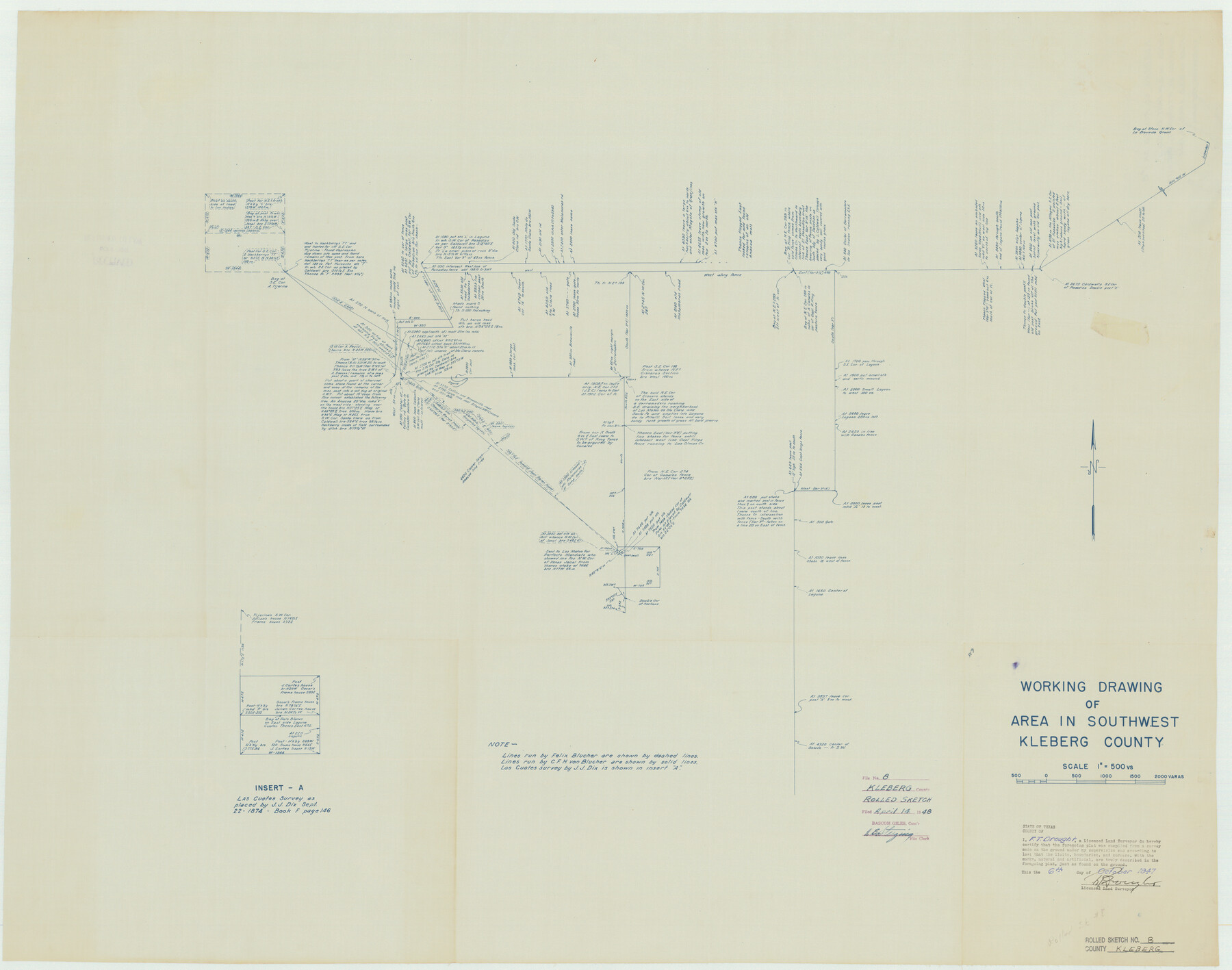
Kleberg County Rolled Sketch 8
Working drawing of area in southwest Kleberg County
-
Map/Doc
9360
-
Collection
General Map Collection
-
Object Dates
1947/10/6 (Creation Date)
1948/4/14 (File Date)
-
People and Organizations
F.T. Drought (Surveyor/Engineer)
-
Counties
Kleberg
-
Subjects
Surveying Rolled Sketch
-
Height x Width
33.0 x 42.0 inches
83.8 x 106.7 cm
-
Medium
blueprint/diazo
-
Scale
1" = 500 varas
Part of: General Map Collection
Trinity County Sketch File 11

Print $8.00
- Digital $50.00
Trinity County Sketch File 11
1859
Size 6.2 x 6.2 inches
Map/Doc 38531
Traveller's Map of the State of Texas

Print $20.00
- Digital $50.00
Traveller's Map of the State of Texas
1867
Size 40.7 x 38.7 inches
Map/Doc 2130
Kendall County Working Sketch 5

Print $20.00
- Digital $50.00
Kendall County Working Sketch 5
1946
Size 30.4 x 28.6 inches
Map/Doc 66677
Harris County Rolled Sketch 96C

Print $3.00
- Digital $50.00
Harris County Rolled Sketch 96C
Size 10.5 x 10.5 inches
Map/Doc 10653
Carson County Sketch File 2

Print $20.00
- Digital $50.00
Carson County Sketch File 2
1888
Size 19.5 x 21.1 inches
Map/Doc 11054
Orange County Sketch File 26

Print $20.00
- Digital $50.00
Orange County Sketch File 26
Size 38.5 x 29.3 inches
Map/Doc 10564
Map of Dallas, Tarrant and part of Ellis County and Peters Colony

Print $20.00
- Digital $50.00
Map of Dallas, Tarrant and part of Ellis County and Peters Colony
1853
Size 25.8 x 32.0 inches
Map/Doc 1970
Houston County Rolled Sketch 12

Print $20.00
- Digital $50.00
Houston County Rolled Sketch 12
Size 11.8 x 18.1 inches
Map/Doc 95396
Map of Travis County

Print $40.00
- Digital $50.00
Map of Travis County
1894
Size 49.8 x 58.8 inches
Map/Doc 16904
Titus County Working Sketch 2

Print $20.00
- Digital $50.00
Titus County Working Sketch 2
Size 23.6 x 25.3 inches
Map/Doc 69363
Freestone County Sketch File 18

Print $4.00
- Digital $50.00
Freestone County Sketch File 18
1854
Size 9.7 x 8.2 inches
Map/Doc 23076
Hartley County Boundary File 4

Print $56.00
- Digital $50.00
Hartley County Boundary File 4
Size 8.6 x 20.7 inches
Map/Doc 54495
You may also like
Wichita County Rolled Sketch 11

Print $20.00
- Digital $50.00
Wichita County Rolled Sketch 11
Size 20.8 x 18.6 inches
Map/Doc 8248
Donley County Sketch File 3

Print $6.00
- Digital $50.00
Donley County Sketch File 3
Size 10.8 x 11.9 inches
Map/Doc 21217

[Overlay for Fractional Township No. 7 South Range No. 17 East of the Indian Meridian, Indian Territory]
![75230, [Overlay for Fractional Township No. 7 South Range No. 17 East of the Indian Meridian, Indian Territory], General Map Collection](https://historictexasmaps.com/wmedia_w700/maps/75230.tif.jpg)
Print $3.00
- Digital $50.00
[Overlay for Fractional Township No. 7 South Range No. 17 East of the Indian Meridian, Indian Territory]
Size 11.2 x 11.7 inches
Map/Doc 75230
Moore County Sketch File 1

Print $20.00
- Digital $50.00
Moore County Sketch File 1
Size 28.9 x 38.6 inches
Map/Doc 10552
Wise County Working Sketch 1

Print $20.00
- Digital $50.00
Wise County Working Sketch 1
1929
Size 22.4 x 19.4 inches
Map/Doc 72615
General Highway Map, El Paso County, Texas

Print $20.00
General Highway Map, El Paso County, Texas
1961
Size 18.2 x 24.8 inches
Map/Doc 79458
Flight Mission No. CRC-5R, Frame 44, Chambers County

Print $20.00
- Digital $50.00
Flight Mission No. CRC-5R, Frame 44, Chambers County
1956
Size 18.6 x 22.4 inches
Map/Doc 84963
[Blocks B12 and 6T]
![91512, [Blocks B12 and 6T], Twichell Survey Records](https://historictexasmaps.com/wmedia_w700/maps/91512-1.tif.jpg)
Print $2.00
- Digital $50.00
[Blocks B12 and 6T]
Size 14.6 x 8.9 inches
Map/Doc 91512
Lubbock County Sketch File 9

Print $4.00
- Digital $50.00
Lubbock County Sketch File 9
1907
Size 5.7 x 8.7 inches
Map/Doc 30430
Map of Webb County

Print $20.00
- Digital $50.00
Map of Webb County
1895
Size 34.8 x 27.0 inches
Map/Doc 4132
General Highway Map, Comanche County, Texas

Print $20.00
General Highway Map, Comanche County, Texas
1940
Size 25.3 x 18.4 inches
Map/Doc 79056