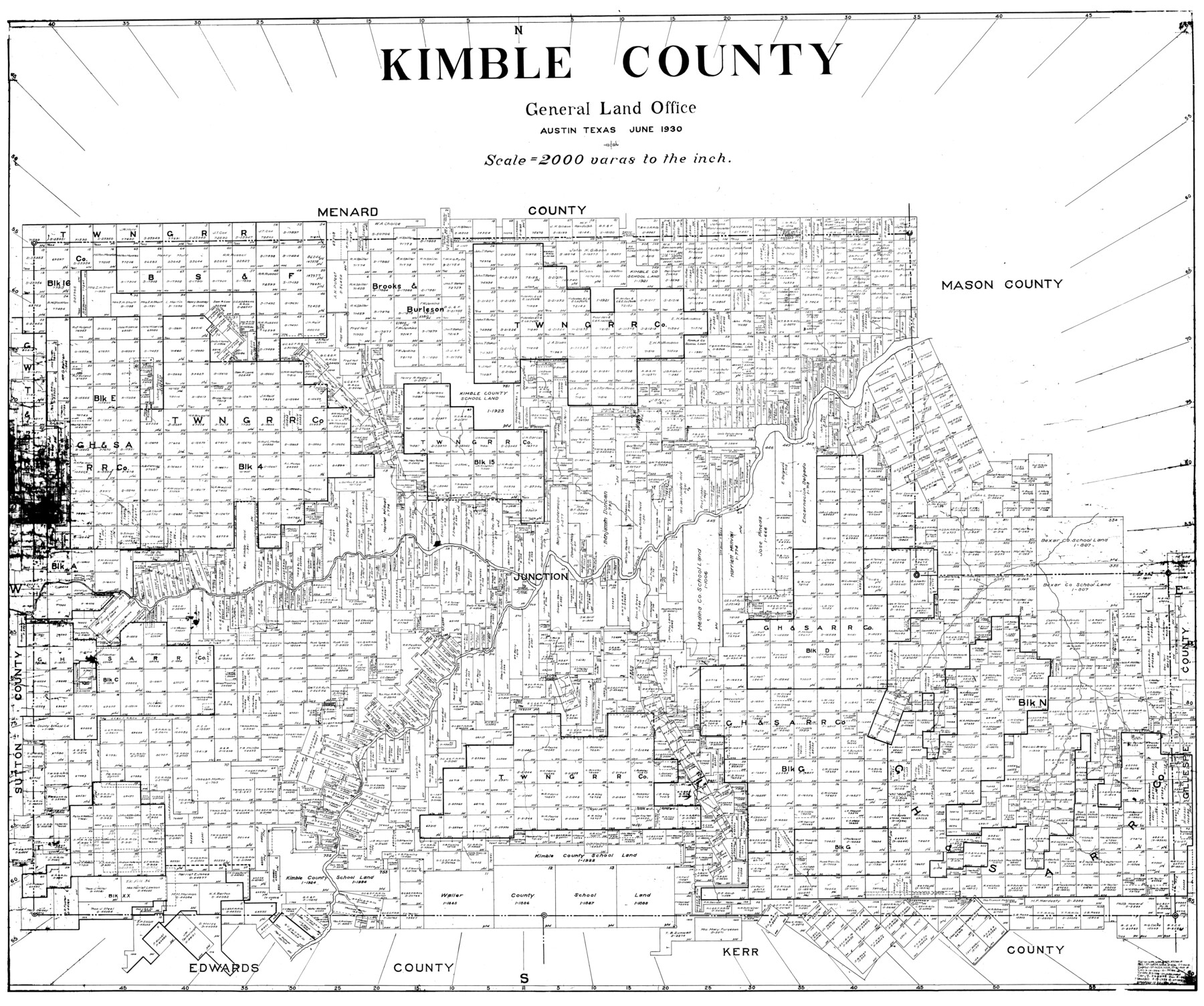
Kimble County
-
Map/Doc
77340
-
Collection
General Map Collection
-
Object Dates
1930 (Creation Date)
-
Counties
Kimble
-
Subjects
County
-
Height x Width
41.0 x 49.0 inches
104.1 x 124.5 cm
Part of: General Map Collection

Hemphill County Rolled Sketch MJ

Print $20.00
- Digital $50.00
Hemphill County Rolled Sketch MJ
Size 21.3 x 41.4 inches
Map/Doc 6201
La Salle County Working Sketch 5

Print $20.00
- Digital $50.00
La Salle County Working Sketch 5
1915
Size 17.2 x 13.4 inches
Map/Doc 70306
Freestone County Rolled Sketch 13B

Print $20.00
- Digital $50.00
Freestone County Rolled Sketch 13B
1989
Size 25.2 x 20.5 inches
Map/Doc 5915
Morris County Sketch File 4

Print $4.00
- Digital $50.00
Morris County Sketch File 4
1910
Size 8.3 x 8.6 inches
Map/Doc 31968

Ector County Sketch File 9

Print $5.00
- Digital $50.00
Ector County Sketch File 9
1939
Size 28.7 x 22.2 inches
Map/Doc 11418
Hansford County Working Sketch 5

Print $20.00
- Digital $50.00
Hansford County Working Sketch 5
1967
Size 30.2 x 28.3 inches
Map/Doc 63377
Harris County Rolled Sketch P57

Print $20.00
- Digital $50.00
Harris County Rolled Sketch P57
1929
Size 29.6 x 37.5 inches
Map/Doc 9118
Anderson County Working Sketch 43

Print $20.00
- Digital $50.00
Anderson County Working Sketch 43
1988
Size 37.2 x 33.9 inches
Map/Doc 67043
Presidio County Rolled Sketch 28

Print $20.00
- Digital $50.00
Presidio County Rolled Sketch 28
1886
Size 25.0 x 45.8 inches
Map/Doc 76140
Aransas County

Print $20.00
- Digital $50.00
Aransas County
1871
Size 17.2 x 18.3 inches
Map/Doc 3235
You may also like
Flight Mission No. DCL-6C, Frame 67, Kenedy County

Print $20.00
- Digital $50.00
Flight Mission No. DCL-6C, Frame 67, Kenedy County
1943
Size 18.6 x 22.2 inches
Map/Doc 85909
The Fisher-Miller Colony. September 1, 1843

Print $20.00
The Fisher-Miller Colony. September 1, 1843
2020
Size 13.8 x 21.7 inches
Map/Doc 96359
Starr County Rolled Sketch 11

Print $20.00
- Digital $50.00
Starr County Rolled Sketch 11
1912
Size 16.5 x 16.4 inches
Map/Doc 7798
Flight Mission No. CGI-3N, Frame 108, Cameron County

Print $20.00
- Digital $50.00
Flight Mission No. CGI-3N, Frame 108, Cameron County
1954
Size 18.6 x 22.2 inches
Map/Doc 84588
Surveys East of Cedar Lake

Print $20.00
- Digital $50.00
Surveys East of Cedar Lake
1824
Size 13.3 x 20.9 inches
Map/Doc 210
El Paso County Working Sketch Graphic Index - south part

Print $20.00
- Digital $50.00
El Paso County Working Sketch Graphic Index - south part
1977
Size 33.4 x 44.9 inches
Map/Doc 76537
Edwards County Working Sketch 7

Print $20.00
- Digital $50.00
Edwards County Working Sketch 7
1918
Size 34.6 x 29.7 inches
Map/Doc 68883
Map of Jack County

Print $20.00
- Digital $50.00
Map of Jack County
1882
Size 21.6 x 24.5 inches
Map/Doc 3706
Hansford County Working Sketch 8

Print $20.00
- Digital $50.00
Hansford County Working Sketch 8
1971
Size 26.2 x 19.3 inches
Map/Doc 63380
City Leased Property in Bailey County, Texas

Print $40.00
- Digital $50.00
City Leased Property in Bailey County, Texas
1952
Size 65.9 x 42.7 inches
Map/Doc 89868
Real County Sketch File 3

Print $16.00
- Digital $50.00
Real County Sketch File 3
1906
Size 9.2 x 8.2 inches
Map/Doc 35039
Culberson County Working Sketch 84

Print $20.00
- Digital $50.00
Culberson County Working Sketch 84
1980
Size 43.5 x 42.9 inches
Map/Doc 68538