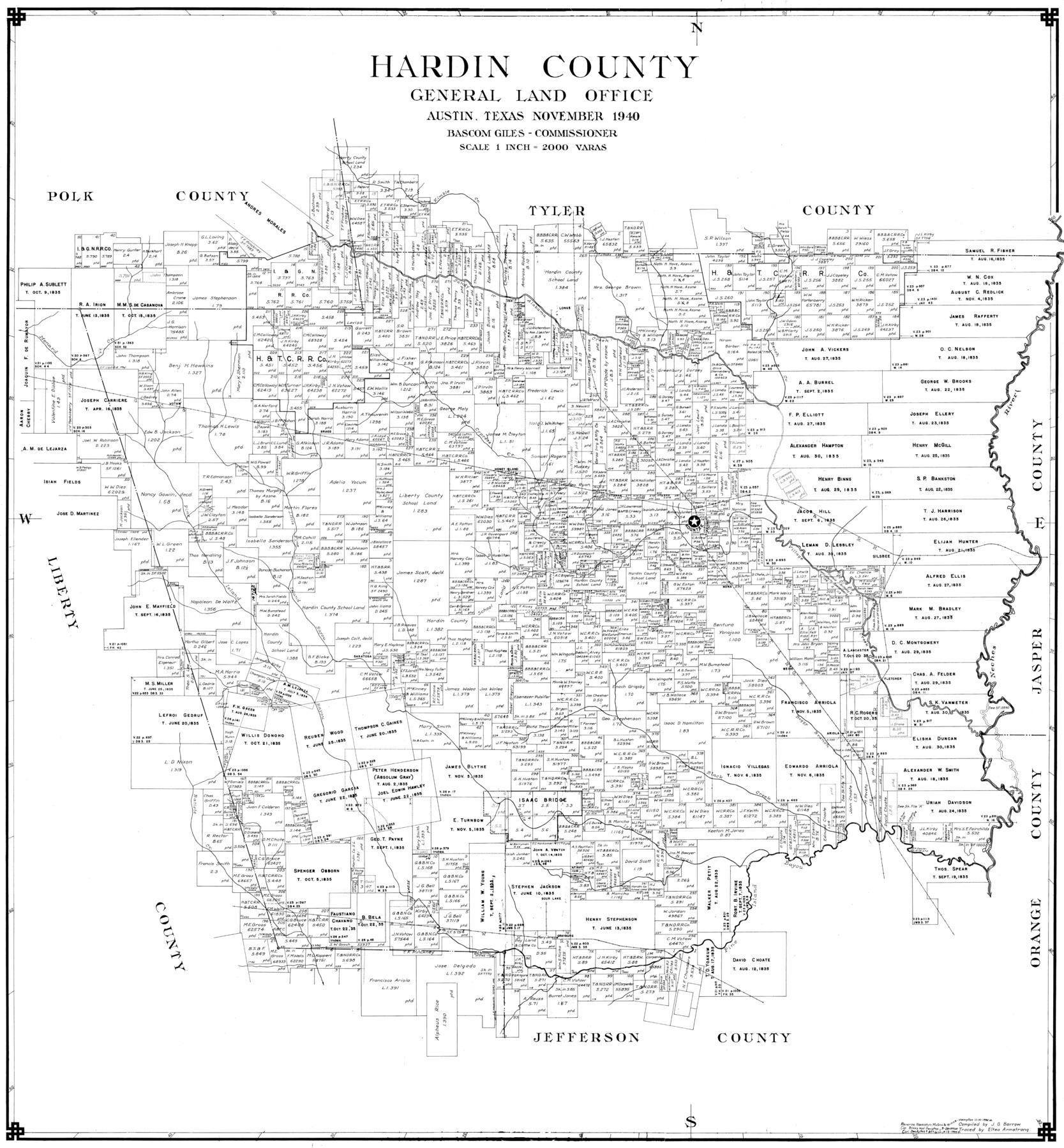
Hardin County
-
Map/Doc
77303
-
Collection
General Map Collection
-
Object Dates
1940 (Creation Date)
-
People and Organizations
Eltea Armstrong (Draftsman)
J.O. Barrow (Compiler)
-
Counties
Hardin
-
Subjects
County
-
Height x Width
40.7 x 37.7 inches
103.4 x 95.8 cm
Part of: General Map Collection
Denton County Rolled Sketch 6

Print $20.00
- Digital $50.00
Denton County Rolled Sketch 6
1983
Size 25.4 x 37.2 inches
Map/Doc 5702
Floyd County Rolled Sketch 11

Print $20.00
- Digital $50.00
Floyd County Rolled Sketch 11
2000
Size 15.5 x 20.9 inches
Map/Doc 5884
Refugio County Working Sketch 9

Print $20.00
- Digital $50.00
Refugio County Working Sketch 9
1941
Size 38.6 x 28.3 inches
Map/Doc 63518
Stonewall County Working Sketch 9

Print $20.00
- Digital $50.00
Stonewall County Working Sketch 9
1950
Size 27.9 x 34.1 inches
Map/Doc 62316
Stephens County Sketch File 7

Print $4.00
- Digital $50.00
Stephens County Sketch File 7
1875
Size 8.1 x 9.9 inches
Map/Doc 37025
Rio Grande, Hargill Sheet

Print $20.00
- Digital $50.00
Rio Grande, Hargill Sheet
1937
Size 37.3 x 37.8 inches
Map/Doc 65109
Flight Mission No. BRA-17M, Frame 13, Jefferson County

Print $20.00
- Digital $50.00
Flight Mission No. BRA-17M, Frame 13, Jefferson County
1953
Size 18.6 x 22.3 inches
Map/Doc 85794
San Patricio County Rolled Sketch 42

Print $20.00
- Digital $50.00
San Patricio County Rolled Sketch 42
Size 18.6 x 37.3 inches
Map/Doc 7728
Brooks County Rolled Sketch 29

Print $20.00
- Digital $50.00
Brooks County Rolled Sketch 29
1947
Size 31.3 x 22.9 inches
Map/Doc 5347
Flight Mission No. DCL-5C, Frame 71, Kenedy County

Print $20.00
- Digital $50.00
Flight Mission No. DCL-5C, Frame 71, Kenedy County
1943
Size 18.5 x 22.2 inches
Map/Doc 85854
Starr County Sketch File 19

Print $20.00
- Digital $50.00
Starr County Sketch File 19
1887
Size 22.6 x 22.0 inches
Map/Doc 12330
Howard County Boundary File 4b

Print $24.00
- Digital $50.00
Howard County Boundary File 4b
Size 11.3 x 8.9 inches
Map/Doc 55168
You may also like
Map of the Paluxy Artesian Reservoirs of the Black and Grand Prairies of Texas including the Eastern and Western Cross Timbers

Print $20.00
- Digital $50.00
Map of the Paluxy Artesian Reservoirs of the Black and Grand Prairies of Texas including the Eastern and Western Cross Timbers
1900
Size 24.8 x 24.4 inches
Map/Doc 75919

El Paso County Boundary File 25

Print $10.00
- Digital $50.00
El Paso County Boundary File 25
Size 13.0 x 8.9 inches
Map/Doc 53226
Panola County Working Sketch 14

Print $40.00
- Digital $50.00
Panola County Working Sketch 14
1945
Map/Doc 71423
Flight Mission No. DQN-3K, Frame 6, Calhoun County

Print $20.00
- Digital $50.00
Flight Mission No. DQN-3K, Frame 6, Calhoun County
1953
Size 18.4 x 22.2 inches
Map/Doc 84338
Flight Mission No. BRA-16M, Frame 53, Jefferson County

Print $20.00
- Digital $50.00
Flight Mission No. BRA-16M, Frame 53, Jefferson County
1953
Size 18.4 x 22.6 inches
Map/Doc 85670
Map of Texas. The Proposed Reoccupation of the Rio Grande -- Its Importance to the Union

Print $20.00
Map of Texas. The Proposed Reoccupation of the Rio Grande -- Its Importance to the Union
1863
Size 14.1 x 8.7 inches
Map/Doc 76263
J. C. Landon's Subdivision of Sherman County School Land situated in Cochran Co., Texas

Print $20.00
- Digital $50.00
J. C. Landon's Subdivision of Sherman County School Land situated in Cochran Co., Texas
1925
Size 14.1 x 22.9 inches
Map/Doc 90291
Hutchinson County

Print $20.00
- Digital $50.00
Hutchinson County
Size 18.4 x 17.7 inches
Map/Doc 3695
Randall County Rolled Sketch 9

Print $20.00
- Digital $50.00
Randall County Rolled Sketch 9
Size 47.5 x 35.8 inches
Map/Doc 9808
Harris County Rolled Sketch T2

Print $20.00
- Digital $50.00
Harris County Rolled Sketch T2
1916
Size 26.8 x 23.2 inches
Map/Doc 6145
Red River County Working Sketch 29

Print $20.00
- Digital $50.00
Red River County Working Sketch 29
1961
Size 29.5 x 33.3 inches
Map/Doc 72012