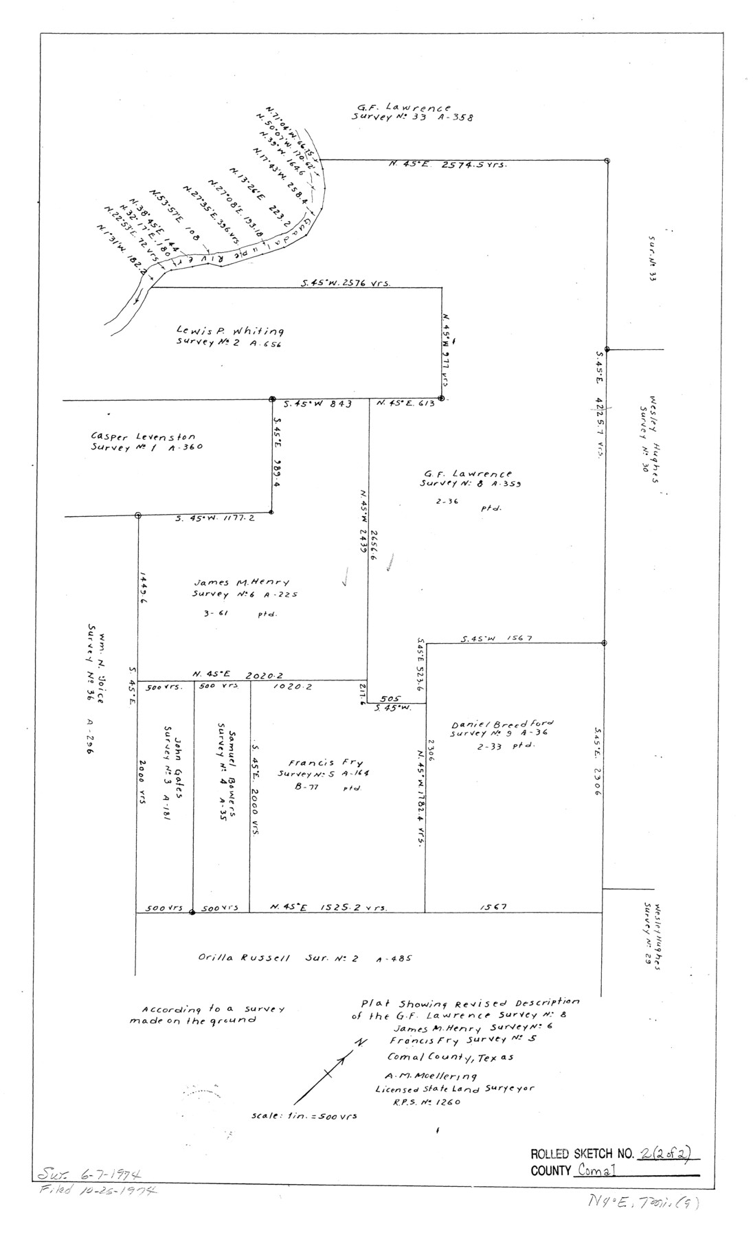
Comal County Rolled Sketch 2
Plat showing revised description of the G.F. Lawrence survey no. 8, James M. Henry survey no. 6, Francis Fry survey no. 5
-
Map/Doc
5537
-
Collection
General Map Collection
-
Object Dates
1974 (Creation Date)
1974/10/26 (File Date)
-
People and Organizations
A.M. Moellering (Surveyor/Engineer)
-
Counties
Comal
-
Subjects
Surveying Rolled Sketch
-
Height x Width
21.8 x 13.3 inches
55.4 x 33.8 cm
-
Scale
1" = 500 varas
Part of: General Map Collection
Hunt County Working Sketch Graphic Index

Print $40.00
- Digital $50.00
Hunt County Working Sketch Graphic Index
1944
Size 50.5 x 37.0 inches
Map/Doc 76585
Dallas County Working Sketch 18

Print $20.00
- Digital $50.00
Dallas County Working Sketch 18
1989
Size 39.9 x 37.4 inches
Map/Doc 68584
Travis County Sketch File 22

Print $6.00
- Digital $50.00
Travis County Sketch File 22
1875
Size 8.5 x 8.5 inches
Map/Doc 38327
Pecos County Rolled Sketch 70

Print $40.00
- Digital $50.00
Pecos County Rolled Sketch 70
1929
Size 49.3 x 21.6 inches
Map/Doc 9708
Schleicher County Rolled Sketch 4

Print $20.00
- Digital $50.00
Schleicher County Rolled Sketch 4
Size 17.4 x 24.5 inches
Map/Doc 7747
Bosque County Sketch File 3

Print $40.00
- Digital $50.00
Bosque County Sketch File 3
1848
Size 16.1 x 12.4 inches
Map/Doc 14742
Map of the State of Texas [East Part]
![81920, Map of the State of Texas [East Part], General Map Collection](https://historictexasmaps.com/wmedia_w700/maps/81920.tif.jpg)
Print $40.00
- Digital $50.00
Map of the State of Texas [East Part]
1938
Size 67.8 x 37.3 inches
Map/Doc 81920
Kerr County Working Sketch 7

Print $20.00
- Digital $50.00
Kerr County Working Sketch 7
1947
Size 38.9 x 30.8 inches
Map/Doc 70038
[Surveys in DeLeon's Colony along the Garcitas River and Arenosa Creek, including the Victoria town tract]
![42, [Surveys in DeLeon's Colony along the Garcitas River and Arenosa Creek, including the Victoria town tract], General Map Collection](https://historictexasmaps.com/wmedia_w700/maps/42.tif.jpg)
Print $20.00
- Digital $50.00
[Surveys in DeLeon's Colony along the Garcitas River and Arenosa Creek, including the Victoria town tract]
1824
Size 22.1 x 17.6 inches
Map/Doc 42
Potter County Sketch File 11

Print $4.00
- Digital $50.00
Potter County Sketch File 11
1890
Size 14.0 x 8.8 inches
Map/Doc 34397
Flight Mission No. DQO-8K, Frame 71, Galveston County

Print $20.00
- Digital $50.00
Flight Mission No. DQO-8K, Frame 71, Galveston County
1952
Size 18.6 x 22.4 inches
Map/Doc 85175
Coke County Sketch File 10

Print $6.00
- Digital $50.00
Coke County Sketch File 10
1892
Size 10.7 x 8.1 inches
Map/Doc 18587
You may also like
Nueces County Rolled Sketch 113A

Print $20.00
- Digital $50.00
Nueces County Rolled Sketch 113A
1972
Size 18.6 x 23.3 inches
Map/Doc 7122
Flight Mission No. DIX-6P, Frame 118, Aransas County

Print $20.00
- Digital $50.00
Flight Mission No. DIX-6P, Frame 118, Aransas County
1956
Size 19.1 x 22.9 inches
Map/Doc 83824
Wharton County Working Sketch 15

Print $20.00
- Digital $50.00
Wharton County Working Sketch 15
1957
Size 22.1 x 25.9 inches
Map/Doc 72479
[Sketch N, showing Blocks C-10, C-14 through C-16]
![91772, [Sketch N, showing Blocks C-10, C-14 through C-16], Twichell Survey Records](https://historictexasmaps.com/wmedia_w700/maps/91772-1.tif.jpg)
Print $20.00
- Digital $50.00
[Sketch N, showing Blocks C-10, C-14 through C-16]
Size 38.6 x 22.1 inches
Map/Doc 91772
Kaufman County Sketch File 16

Print $4.00
- Digital $50.00
Kaufman County Sketch File 16
Size 10.1 x 8.1 inches
Map/Doc 28655
Reagan County Sketch File 19

Print $26.00
- Digital $50.00
Reagan County Sketch File 19
1937
Size 14.0 x 28.7 inches
Map/Doc 12220
Newton County Sketch File 44

Print $8.00
- Digital $50.00
Newton County Sketch File 44
1945
Size 11.2 x 8.6 inches
Map/Doc 32441

Brooks County Sketch File 10

Print $2.00
- Digital $50.00
Brooks County Sketch File 10
1988
Size 14.4 x 9.0 inches
Map/Doc 16572
Coast Chart No. 209 - Aransas Pass, Aransas and Copano Bays, Texas

Print $20.00
- Digital $50.00
Coast Chart No. 209 - Aransas Pass, Aransas and Copano Bays, Texas
1906
Size 40.2 x 33.8 inches
Map/Doc 73430
William T. Brewster and Surrounding Surveys]
![91024, William T. Brewster and Surrounding Surveys], Twichell Survey Records](https://historictexasmaps.com/wmedia_w700/maps/91024-1.tif.jpg)
Print $20.00
- Digital $50.00
William T. Brewster and Surrounding Surveys]
Size 20.3 x 36.8 inches
Map/Doc 91024
Flight Mission No. CLL-1N, Frame 8, Willacy County

Print $20.00
- Digital $50.00
Flight Mission No. CLL-1N, Frame 8, Willacy County
1954
Size 18.3 x 22.1 inches
Map/Doc 86995