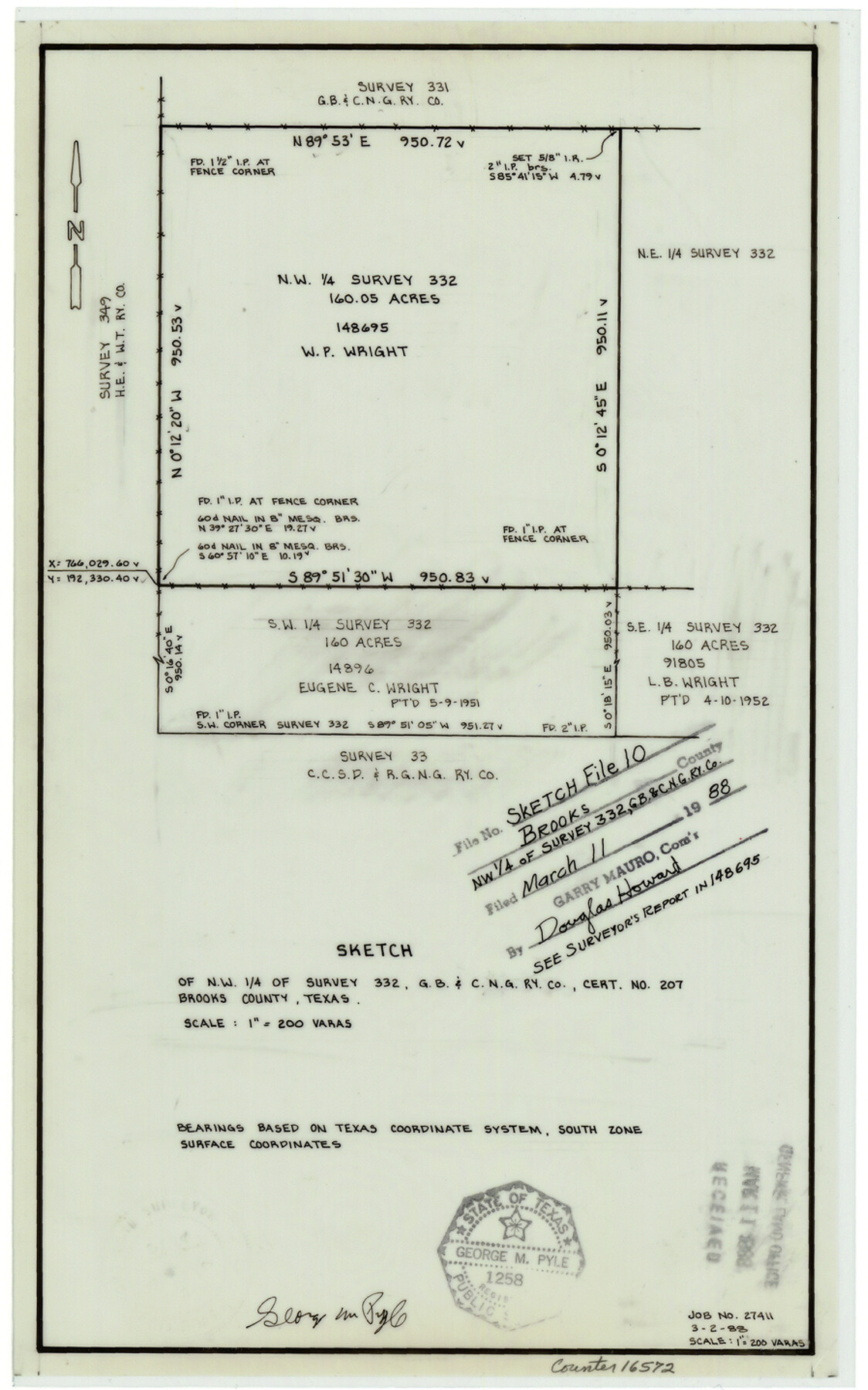
Brooks County Sketch File 10
Sketch of NW 1/4 of survey 332, G. B. & C. N. G. Ry. Co., cert. no. 207, Brooks County, Texas
-
Map/Doc
16572
-
Collection
General Map Collection
-
Object Dates
1988/3/2 (Creation Date)
1988/3/11 (File Date)
-
People and Organizations
George M. Pyle (Surveyor/Engineer)
-
Counties
Brooks
-
Subjects
Surveying Sketch File
-
Height x Width
14.4 x 9.0 inches
36.6 x 22.9 cm
-
Medium
mylar, print
-
Scale
1" = 200 varas
-
Comments
See surveyor's report in School File 148695.
Part of: General Map Collection
Montgomery County Working Sketch 33

Print $20.00
- Digital $50.00
Montgomery County Working Sketch 33
1950
Size 28.8 x 28.2 inches
Map/Doc 71140
Wood County Working Sketch 13

Print $20.00
- Digital $50.00
Wood County Working Sketch 13
1973
Size 23.1 x 20.2 inches
Map/Doc 62013
Flight Mission No. BRA-16M, Frame 48, Jefferson County

Print $20.00
- Digital $50.00
Flight Mission No. BRA-16M, Frame 48, Jefferson County
1953
Size 18.6 x 22.5 inches
Map/Doc 85665
Capitol Land Reservation

Print $20.00
- Digital $50.00
Capitol Land Reservation
1880
Size 27.1 x 34.4 inches
Map/Doc 10746
Coke County Working Sketch 19

Print $20.00
- Digital $50.00
Coke County Working Sketch 19
1948
Size 22.2 x 29.0 inches
Map/Doc 68056
DeWitt County Working Sketch Graphic Index

Print $20.00
- Digital $50.00
DeWitt County Working Sketch Graphic Index
1920
Size 39.7 x 46.7 inches
Map/Doc 76522
Howard County Boundary File 2

Print $14.00
- Digital $50.00
Howard County Boundary File 2
Size 9.4 x 4.6 inches
Map/Doc 55111
Fort Bend County Sketch File 18 1/2

Print $20.00
- Digital $50.00
Fort Bend County Sketch File 18 1/2
1896
Size 18.3 x 15.3 inches
Map/Doc 11508
Pecos County Rolled Sketch P

Print $20.00
- Digital $50.00
Pecos County Rolled Sketch P
1885
Size 39.0 x 46.1 inches
Map/Doc 9686
Crockett County Rolled Sketch 67

Print $20.00
- Digital $50.00
Crockett County Rolled Sketch 67
1948
Size 34.2 x 21.7 inches
Map/Doc 5610
Outer Continental Shelf Leasing Maps (Louisiana Offshore Operations)

Print $20.00
- Digital $50.00
Outer Continental Shelf Leasing Maps (Louisiana Offshore Operations)
1955
Size 19.9 x 13.4 inches
Map/Doc 75860
State Prison System, Cherokee County

Print $20.00
- Digital $50.00
State Prison System, Cherokee County
Size 15.7 x 33.1 inches
Map/Doc 73560
You may also like
Map Showing a Resurvey of Part of Blk. I, H. &. G. N. Ry. Co. Pecos County, Texas, following field notes copied from Jacob Kuechler's field book of his original survey made in October and November 1876

Print $20.00
- Digital $50.00
Map Showing a Resurvey of Part of Blk. I, H. &. G. N. Ry. Co. Pecos County, Texas, following field notes copied from Jacob Kuechler's field book of his original survey made in October and November 1876
1930
Size 19.2 x 14.4 inches
Map/Doc 91549
Right of Way and Track Map Texas & New Orleans R.R. Co. operated by the T. & N. O. R.R. Co. Dallas-Sabine Branch

Print $40.00
- Digital $50.00
Right of Way and Track Map Texas & New Orleans R.R. Co. operated by the T. & N. O. R.R. Co. Dallas-Sabine Branch
1918
Size 26.4 x 56.7 inches
Map/Doc 64154
Sutton County Sketch File 27a

Print $6.00
- Digital $50.00
Sutton County Sketch File 27a
Size 11.3 x 8.8 inches
Map/Doc 37466

Wilson County Sketch File 1

Print $6.00
- Digital $50.00
Wilson County Sketch File 1
1858
Size 10.4 x 7.5 inches
Map/Doc 40396
[Sections 27 and 28, Block B-19]
![91857, [Sections 27 and 28, Block B-19], Twichell Survey Records](https://historictexasmaps.com/wmedia_w700/maps/91857-1.tif.jpg)
Print $2.00
- Digital $50.00
[Sections 27 and 28, Block B-19]
Size 14.6 x 9.1 inches
Map/Doc 91857
Denton County Sketch File 18

Print $4.00
- Digital $50.00
Denton County Sketch File 18
1856
Size 7.9 x 7.3 inches
Map/Doc 20731
Floyd County Rolled Sketch 9

Print $323.00
- Digital $50.00
Floyd County Rolled Sketch 9
1953
Size 10.0 x 15.7 inches
Map/Doc 44564
Map No. 1 - Rio Bravo del Norte section of boundary between the United States & Mexico agreed upon by the Joint Commission under the Treaty of Guadalupe Hidalgo

Print $20.00
- Digital $50.00
Map No. 1 - Rio Bravo del Norte section of boundary between the United States & Mexico agreed upon by the Joint Commission under the Treaty of Guadalupe Hidalgo
1852
Size 18.4 x 27.0 inches
Map/Doc 72866
Flight Mission No. BQR-13K, Frame 165, Brazoria County

Print $20.00
- Digital $50.00
Flight Mission No. BQR-13K, Frame 165, Brazoria County
1952
Size 18.8 x 22.3 inches
Map/Doc 84090
General Highway Map, Schleicher County, Sutton County, Texas

Print $20.00
General Highway Map, Schleicher County, Sutton County, Texas
1940
Size 18.3 x 25.0 inches
Map/Doc 79239
Flight Mission No. DQN-2K, Frame 25, Calhoun County

Print $20.00
- Digital $50.00
Flight Mission No. DQN-2K, Frame 25, Calhoun County
1953
Size 18.8 x 22.4 inches
Map/Doc 84232