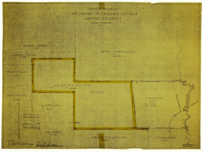
Newton County Sketch File 44
[Report of a resurvey of I. & G. N. survey no. 4, A-245]
-
Map/Doc
32441
-
Collection
General Map Collection
-
Object Dates
5/11/1945 (Creation Date)
6/1/1945 (File Date)
-
People and Organizations
James G. Barker (Surveyor/Engineer)
-
Counties
Newton
-
Subjects
Surveying Sketch File
-
Height x Width
11.2 x 8.6 inches
28.5 x 21.8 cm
-
Medium
paper, print
-
Comments
See Newton County Rolled Sketch 8 (6844).
-
Features
Cow Creek
State Highway 87
Related maps
Newton County Rolled Sketch 8
Print $20.00
- Digital $50.00
Newton County Rolled Sketch 8
1945
Size 21.5 x 28.7 inches
Map/Doc 6844
Part of: General Map Collection
Map of Cameron County

Print $20.00
- Digital $50.00
Map of Cameron County
1873
Size 42.9 x 24.3 inches
Map/Doc 66744
Harrison County Sketch File 18

Print $20.00
- Digital $50.00
Harrison County Sketch File 18
1954
Size 23.2 x 26.9 inches
Map/Doc 11691
Howard County Sketch File 3

Print $12.00
- Digital $50.00
Howard County Sketch File 3
1909
Size 9.0 x 8.3 inches
Map/Doc 26855
Marion County Working Sketch 34

Print $20.00
- Digital $50.00
Marion County Working Sketch 34
1983
Size 45.2 x 23.2 inches
Map/Doc 70810
Kimble County Working Sketch 40

Print $40.00
- Digital $50.00
Kimble County Working Sketch 40
1948
Size 53.0 x 38.4 inches
Map/Doc 70108
Sabine County Working Sketch 2

Print $3.00
- Digital $50.00
Sabine County Working Sketch 2
1906
Size 12.5 x 10.8 inches
Map/Doc 63673
Austin County Boundary File 2

Print $32.00
- Digital $50.00
Austin County Boundary File 2
Size 22.4 x 30.7 inches
Map/Doc 50236
Flight Mission No. CRC-3R, Frame 20, Chambers County

Print $20.00
- Digital $50.00
Flight Mission No. CRC-3R, Frame 20, Chambers County
1956
Size 18.6 x 22.2 inches
Map/Doc 84794
Bandera County Working Sketch 25

Print $20.00
- Digital $50.00
Bandera County Working Sketch 25
1950
Size 30.4 x 38.5 inches
Map/Doc 67621
Lamb County Sketch File 9

Print $4.00
- Digital $50.00
Lamb County Sketch File 9
1910
Size 10.9 x 7.2 inches
Map/Doc 29358
Controlled Mosaic by Jack Amman Photogrammetric Engineers, Inc - Sheet 32

Print $20.00
- Digital $50.00
Controlled Mosaic by Jack Amman Photogrammetric Engineers, Inc - Sheet 32
1954
Size 20.0 x 24.0 inches
Map/Doc 83485
Brazos County Working Sketch 5

Print $20.00
- Digital $50.00
Brazos County Working Sketch 5
1978
Size 23.9 x 18.4 inches
Map/Doc 67480
You may also like
F. Z. Bishop's Subdivision of Armstrong's Ranch, Gaines County, Texas

Print $20.00
- Digital $50.00
F. Z. Bishop's Subdivision of Armstrong's Ranch, Gaines County, Texas
1924
Size 22.7 x 21.5 inches
Map/Doc 92653

Liberty County Sketch File 21

Print $5.00
- Digital $50.00
Liberty County Sketch File 21
1858
Size 7.9 x 13.0 inches
Map/Doc 29928
Knox County Rolled Sketch 24

Print $20.00
- Digital $50.00
Knox County Rolled Sketch 24
2007
Size 28.5 x 34.5 inches
Map/Doc 87722
Runnels County

Print $20.00
- Digital $50.00
Runnels County
1879
Size 22.1 x 19.2 inches
Map/Doc 3999
Right of Way and Track Map, The Missouri, Kansas and Texas Ry. of Texas operated by the Missouri, Kansas and Texas Ry. of Texas, Henrietta Division

Print $40.00
- Digital $50.00
Right of Way and Track Map, The Missouri, Kansas and Texas Ry. of Texas operated by the Missouri, Kansas and Texas Ry. of Texas, Henrietta Division
1918
Size 25.4 x 57.2 inches
Map/Doc 64073
Childress County, Texas

Print $20.00
- Digital $50.00
Childress County, Texas
1892
Size 29.3 x 22.0 inches
Map/Doc 697
Presidio County Rolled Sketch 68

Print $20.00
- Digital $50.00
Presidio County Rolled Sketch 68
1927
Size 11.8 x 24.4 inches
Map/Doc 7358
[Surveys along the Red River made for titles under Radford Berry, Commissioner]
![32, [Surveys along the Red River made for titles under Radford Berry, Commissioner], General Map Collection](https://historictexasmaps.com/wmedia_w700/maps/32.tif.jpg)
Print $20.00
- Digital $50.00
[Surveys along the Red River made for titles under Radford Berry, Commissioner]
Size 23.3 x 19.5 inches
Map/Doc 32
Crockett County Rolled Sketch P

Print $20.00
- Digital $50.00
Crockett County Rolled Sketch P
1927
Size 24.3 x 47.3 inches
Map/Doc 8696
Duval County Sketch File 35a

Print $26.00
- Digital $50.00
Duval County Sketch File 35a
Size 11.3 x 8.9 inches
Map/Doc 21371
Limestone County Working Sketch 27

Print $20.00
- Digital $50.00
Limestone County Working Sketch 27
2008
Size 34.4 x 35.6 inches
Map/Doc 88767