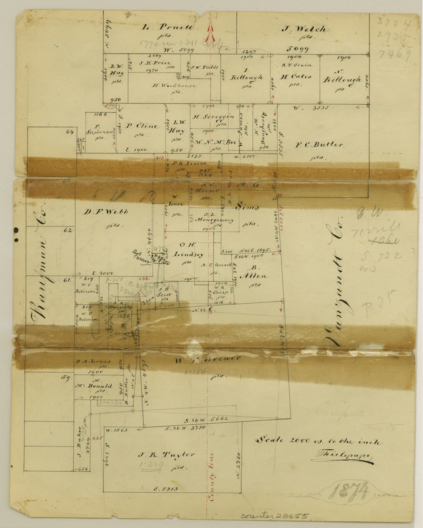
Kaufman County Sketch File 16
[Sketch of area in east part of county along Kaufman-Van Zandt County line]
-
Map/Doc
28655
-
Collection
General Map Collection
-
Object Dates
12/18/1873 (File Date)
-
People and Organizations
Thielepape (Draftsman)
-
Counties
Kaufman Van Zandt
-
Subjects
Surveying Sketch File
-
Height x Width
10.1 x 8.1 inches
25.7 x 20.6 cm
-
Medium
paper, manuscript
-
Scale
1" = 2000 varas
Part of: General Map Collection
Fort Bend County Working Sketch 27

Print $20.00
- Digital $50.00
Fort Bend County Working Sketch 27
1982
Size 17.2 x 19.2 inches
Map/Doc 69233
Duval County Boundary File 1e

Print $40.00
- Digital $50.00
Duval County Boundary File 1e
Size 6.1 x 23.1 inches
Map/Doc 52701
Rusk County Sketch File 35

Print $6.00
Rusk County Sketch File 35
1950
Size 11.3 x 8.8 inches
Map/Doc 35573
Hudspeth County Working Sketch 58

Print $40.00
- Digital $50.00
Hudspeth County Working Sketch 58
1992
Size 25.6 x 50.9 inches
Map/Doc 66343
Sutton County Sketch File 51

Print $6.00
- Digital $50.00
Sutton County Sketch File 51
1947
Size 11.3 x 8.9 inches
Map/Doc 37526
Flight Mission No. BQY-4M, Frame 57, Harris County

Print $20.00
- Digital $50.00
Flight Mission No. BQY-4M, Frame 57, Harris County
1953
Size 18.5 x 22.3 inches
Map/Doc 85266
Lee County Working Sketch 14

Print $20.00
- Digital $50.00
Lee County Working Sketch 14
1981
Size 17.9 x 11.4 inches
Map/Doc 70393
Flight Mission No. CRC-4R, Frame 107, Chambers County

Print $20.00
- Digital $50.00
Flight Mission No. CRC-4R, Frame 107, Chambers County
1956
Size 18.8 x 22.4 inches
Map/Doc 84904
Navarro County Sketch File 14

Print $4.00
- Digital $50.00
Navarro County Sketch File 14
1873
Size 8.4 x 10.2 inches
Map/Doc 32326
[Surveys near Onion Creek]
![108, [Surveys near Onion Creek], General Map Collection](https://historictexasmaps.com/wmedia_w700/maps/108-1.tif.jpg)
Print $2.00
- Digital $50.00
[Surveys near Onion Creek]
1841
Size 11.0 x 7.8 inches
Map/Doc 108
Map of Ellis County

Print $40.00
- Digital $50.00
Map of Ellis County
1889
Size 39.2 x 48.1 inches
Map/Doc 4712
Palo Pinto County

Print $40.00
- Digital $50.00
Palo Pinto County
1941
Size 49.4 x 40.4 inches
Map/Doc 95606
You may also like
Real County Working Sketch 66

Print $20.00
- Digital $50.00
Real County Working Sketch 66
1970
Size 35.5 x 29.4 inches
Map/Doc 71958
Anderson County Working Sketch 31

Print $20.00
- Digital $50.00
Anderson County Working Sketch 31
1966
Size 18.3 x 23.2 inches
Map/Doc 67031
[G. H. & H. Block 2]
![91894, [G. H. & H. Block 2], Twichell Survey Records](https://historictexasmaps.com/wmedia_w700/maps/91894-1.tif.jpg)
Print $20.00
- Digital $50.00
[G. H. & H. Block 2]
Size 20.6 x 18.4 inches
Map/Doc 91894
Cottle County Sketch File 11

Print $40.00
- Digital $50.00
Cottle County Sketch File 11
Size 12.9 x 13.3 inches
Map/Doc 19489
Flight Mission No. DQN-2K, Frame 77, Calhoun County

Print $20.00
- Digital $50.00
Flight Mission No. DQN-2K, Frame 77, Calhoun County
1953
Size 16.1 x 15.9 inches
Map/Doc 84269
Louisiana and Texas Intracoastal Waterway, Section 7, Galveston Bay to Brazos River and Section 8, Brazos River to Matagorda Bay

Print $20.00
- Digital $50.00
Louisiana and Texas Intracoastal Waterway, Section 7, Galveston Bay to Brazos River and Section 8, Brazos River to Matagorda Bay
1937
Size 31.0 x 42.8 inches
Map/Doc 61843
La Salle County Working Sketch 50

Print $40.00
- Digital $50.00
La Salle County Working Sketch 50
1985
Size 50.6 x 26.2 inches
Map/Doc 70351
Sketch of Survey 3, Block 1 in Dickens and King Counties

Print $20.00
- Digital $50.00
Sketch of Survey 3, Block 1 in Dickens and King Counties
1914
Size 10.8 x 28.2 inches
Map/Doc 10766
Maverick County Working Sketch 6

Print $40.00
- Digital $50.00
Maverick County Working Sketch 6
1944
Size 55.9 x 42.4 inches
Map/Doc 70898
Harris County Working Sketch 15

Print $20.00
- Digital $50.00
Harris County Working Sketch 15
1916
Size 29.3 x 41.2 inches
Map/Doc 65907
Flight Mission No. CGI-3N, Frame 136, Cameron County

Print $20.00
- Digital $50.00
Flight Mission No. CGI-3N, Frame 136, Cameron County
1954
Size 18.6 x 22.3 inches
Map/Doc 84609
Flight Mission No. DAG-23K, Frame 16, Matagorda County

Print $20.00
- Digital $50.00
Flight Mission No. DAG-23K, Frame 16, Matagorda County
1953
Size 18.5 x 22.2 inches
Map/Doc 86478