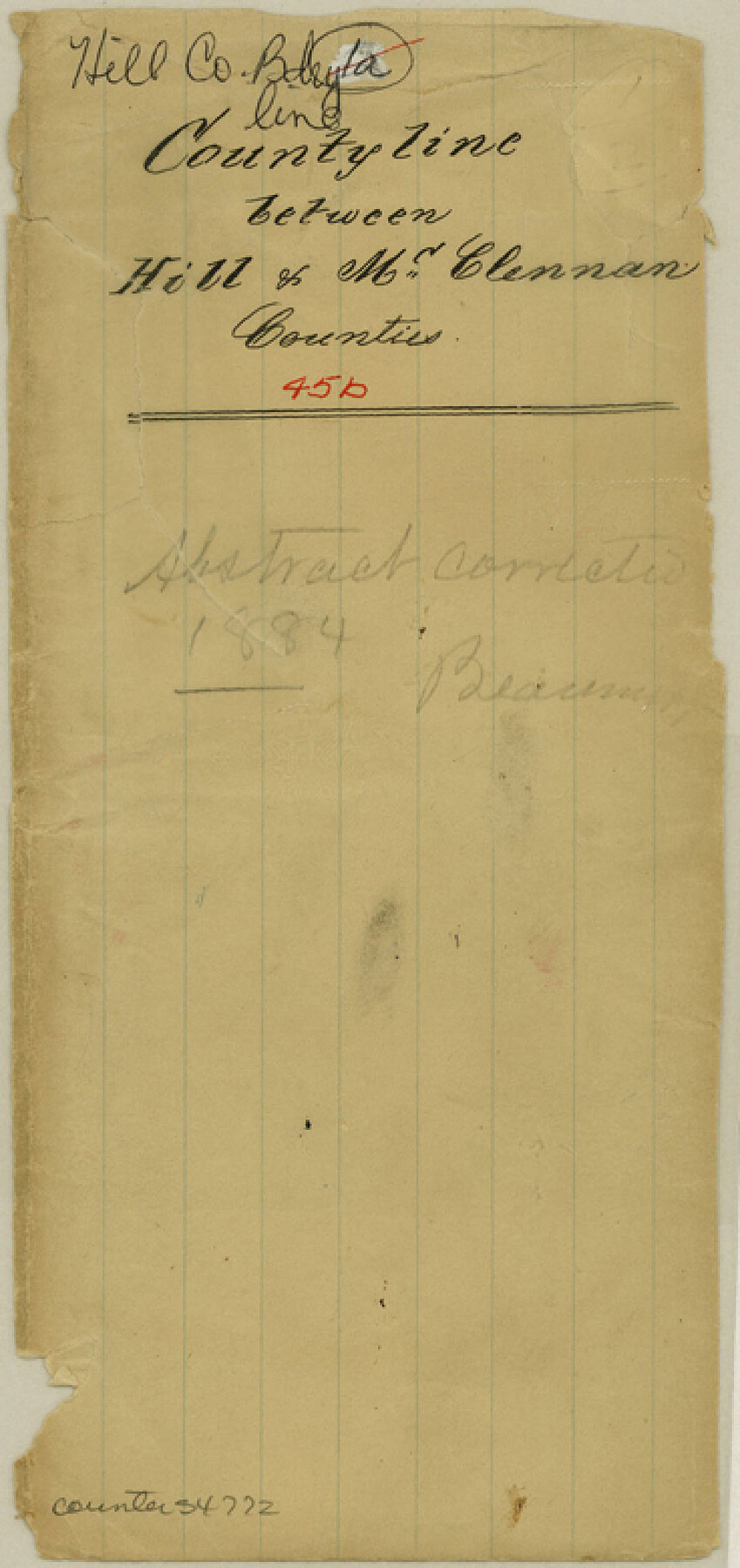
Hill County Boundary File 45b
Line between Hill & McLennan Counties
-
Map/Doc
54772
-
Collection
General Map Collection
-
Counties
Hill
-
Subjects
County Boundaries
-
Height x Width
7.8 x 3.7 inches
19.8 x 9.4 cm
Part of: General Map Collection
Randall County

Print $20.00
- Digital $50.00
Randall County
1958
Size 43.0 x 35.1 inches
Map/Doc 73269
[Galveston, Harrisburg & San Antonio through El Paso County]
![64006, [Galveston, Harrisburg & San Antonio through El Paso County], General Map Collection](https://historictexasmaps.com/wmedia_w700/maps/64006.tif.jpg)
Print $20.00
- Digital $50.00
[Galveston, Harrisburg & San Antonio through El Paso County]
Size 13.5 x 33.7 inches
Map/Doc 64006
San Jacinto County Working Sketch 44

Print $20.00
- Digital $50.00
San Jacinto County Working Sketch 44
1981
Size 20.6 x 11.4 inches
Map/Doc 63758
Archer County Sketch File 10

Print $5.00
- Digital $50.00
Archer County Sketch File 10
Size 10.2 x 15.9 inches
Map/Doc 13642
Runnels County Sketch File 12

Print $20.00
Runnels County Sketch File 12
1883
Size 32.9 x 30.9 inches
Map/Doc 10592
Medina County Working Sketch 8

Print $20.00
- Digital $50.00
Medina County Working Sketch 8
1955
Size 23.4 x 18.4 inches
Map/Doc 70923
Uvalde County Working Sketch 5

Print $20.00
- Digital $50.00
Uvalde County Working Sketch 5
1927
Size 13.4 x 18.0 inches
Map/Doc 72075
Brazoria County Rolled Sketch 51

Print $20.00
- Digital $50.00
Brazoria County Rolled Sketch 51
2007
Size 34.8 x 46.8 inches
Map/Doc 87377
Webb County Working Sketch 96

Print $20.00
- Digital $50.00
Webb County Working Sketch 96
1994
Size 36.1 x 36.3 inches
Map/Doc 72463
[Sketch for Mineral Application 26501 - Sabine River, T. A. Oldhausen]
![2837, [Sketch for Mineral Application 26501 - Sabine River, T. A. Oldhausen], General Map Collection](https://historictexasmaps.com/wmedia_w700/maps/2837.tif.jpg)
Print $20.00
- Digital $50.00
[Sketch for Mineral Application 26501 - Sabine River, T. A. Oldhausen]
1931
Size 24.1 x 36.0 inches
Map/Doc 2837
Galveston County NRC Article 33.136 Sketch 70

Print $24.00
- Digital $50.00
Galveston County NRC Article 33.136 Sketch 70
2012
Size 24.0 x 24.3 inches
Map/Doc 95111
Irion County Rolled Sketch 14

Print $20.00
- Digital $50.00
Irion County Rolled Sketch 14
1946
Size 25.3 x 21.9 inches
Map/Doc 6324
You may also like
Angelina County Sketch File 11c

Print $7.00
- Digital $50.00
Angelina County Sketch File 11c
Size 11.1 x 6.0 inches
Map/Doc 12946
Sketch Showing Property Lines of Harlem State Farm

Print $20.00
- Digital $50.00
Sketch Showing Property Lines of Harlem State Farm
Size 16.0 x 30.2 inches
Map/Doc 62982
Crockett County Sketch File 17

Print $10.00
- Digital $50.00
Crockett County Sketch File 17
1881
Size 12.7 x 8.0 inches
Map/Doc 19678
Edwards County Working Sketch 110

Print $40.00
- Digital $50.00
Edwards County Working Sketch 110
1972
Size 49.7 x 39.6 inches
Map/Doc 68986
Sketch in Gray County

Print $3.00
- Digital $50.00
Sketch in Gray County
1899
Size 10.2 x 11.6 inches
Map/Doc 90659
Hidalgo County Sketch File 7

Print $20.00
- Digital $50.00
Hidalgo County Sketch File 7
1882
Size 20.3 x 28.2 inches
Map/Doc 11761
Nueces County Sketch File 24

Print $2.00
- Digital $50.00
Nueces County Sketch File 24
Size 8.7 x 14.0 inches
Map/Doc 32571
Cass County Rolled Sketch 6

Print $40.00
- Digital $50.00
Cass County Rolled Sketch 6
1957
Size 40.0 x 61.9 inches
Map/Doc 8586
Morris County Rolled Sketch 2A

Print $20.00
- Digital $50.00
Morris County Rolled Sketch 2A
Size 24.0 x 18.8 inches
Map/Doc 10240
[Texas & Pacific Railway through Callahan County]
![64238, [Texas & Pacific Railway through Callahan County], General Map Collection](https://historictexasmaps.com/wmedia_w700/maps/64238.tif.jpg)
Print $20.00
- Digital $50.00
[Texas & Pacific Railway through Callahan County]
1918
Size 22.4 x 9.4 inches
Map/Doc 64238
Map of Schleicher County

Print $20.00
- Digital $50.00
Map of Schleicher County
1887
Size 21.4 x 30.1 inches
Map/Doc 4021
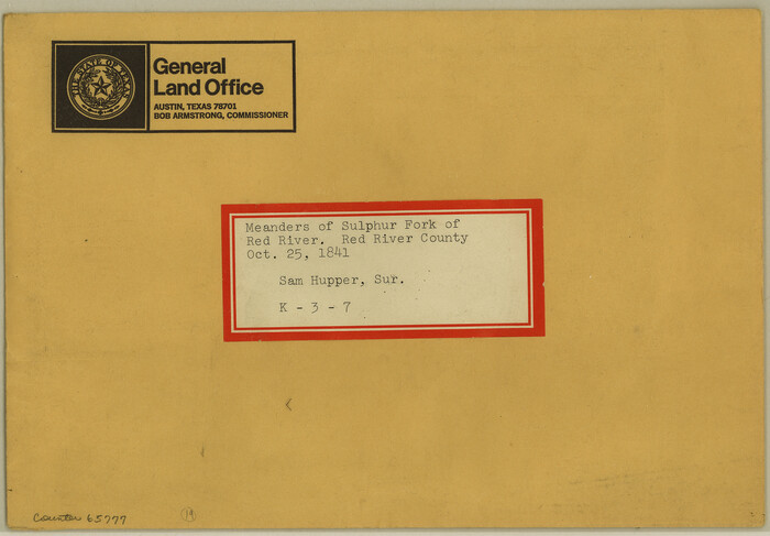
Meanders of Sulphur Fork of Red River, Red River County, Texas
Print $2.00
- Digital $50.00
Meanders of Sulphur Fork of Red River, Red River County, Texas
1841
Size 6.8 x 9.7 inches
Map/Doc 65777