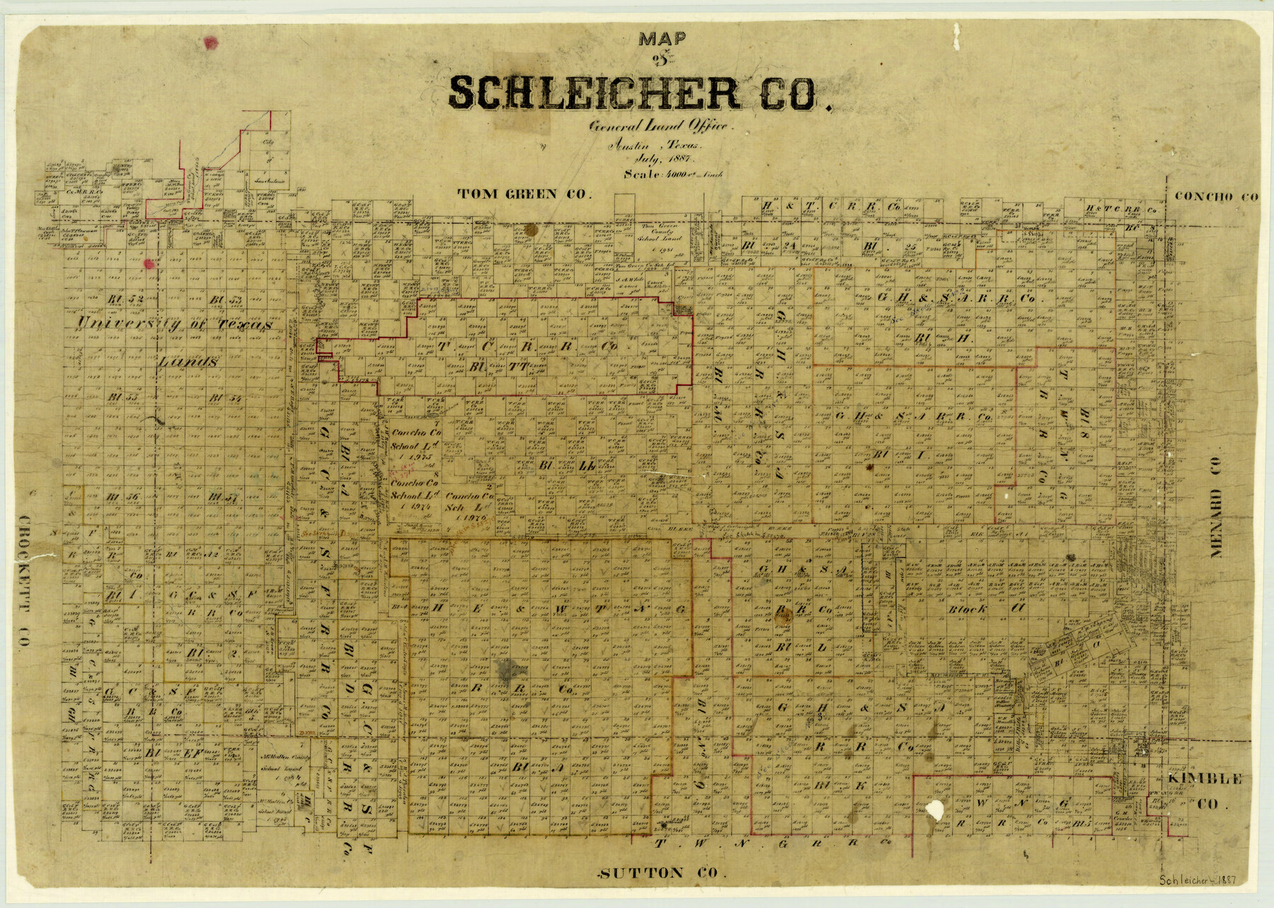
Map of Schleicher County
-
Map/Doc
4021
-
Collection
General Map Collection
-
Object Dates
1887 (Creation Date)
-
People and Organizations
Texas General Land Office (Publisher)
-
Counties
Schleicher
-
Subjects
County
-
Height x Width
21.4 x 30.1 inches
54.4 x 76.5 cm
-
Features
Spring Creek
Monument Hill
Soap Lakes
San Saba River
Mt. Neilswell
Part of: General Map Collection
Flight Mission No. BQR-5K, Frame 66, Brazoria County

Print $20.00
- Digital $50.00
Flight Mission No. BQR-5K, Frame 66, Brazoria County
1952
Size 18.8 x 22.5 inches
Map/Doc 84011
Map of Ramon Musquiz Survey, Meanders of Lavaca & Navidad Rivers, Menefee & Redfish Lakes

Print $20.00
- Digital $50.00
Map of Ramon Musquiz Survey, Meanders of Lavaca & Navidad Rivers, Menefee & Redfish Lakes
1934
Size 23.0 x 18.6 inches
Map/Doc 65456
Terry County Rolled Sketch 5

Print $40.00
- Digital $50.00
Terry County Rolled Sketch 5
Size 56.8 x 38.1 inches
Map/Doc 9995
University Land, Pecos County, Texas

Print $20.00
- Digital $50.00
University Land, Pecos County, Texas
1932
Size 35.7 x 47.5 inches
Map/Doc 2433
Briscoe County Working Sketch 12

Print $40.00
- Digital $50.00
Briscoe County Working Sketch 12
1984
Size 43.6 x 60.3 inches
Map/Doc 67815
Dickens County Rolled Sketch 8

Print $20.00
- Digital $50.00
Dickens County Rolled Sketch 8
1953
Size 42.9 x 23.7 inches
Map/Doc 5707
Flight Mission No. DIX-6P, Frame 187, Aransas County

Print $20.00
- Digital $50.00
Flight Mission No. DIX-6P, Frame 187, Aransas County
1956
Size 19.1 x 22.7 inches
Map/Doc 83849

Wichita County Sketch File A

Print $4.00
- Digital $50.00
Wichita County Sketch File A
1861
Size 7.8 x 10.3 inches
Map/Doc 40036
Dimmit County Sketch File 37

Print $6.00
- Digital $50.00
Dimmit County Sketch File 37
1894
Size 10.4 x 12.7 inches
Map/Doc 21161

Mason County Sketch File 18

Print $4.00
- Digital $50.00
Mason County Sketch File 18
1901
Size 14.0 x 8.6 inches
Map/Doc 30709
You may also like
San Jacinto County Sketch File 23

Print $26.00
San Jacinto County Sketch File 23
1993
Size 14.6 x 8.8 inches
Map/Doc 35803
Ward County Sketch File 13

Print $14.00
- Digital $50.00
Ward County Sketch File 13
1951
Size 14.5 x 8.8 inches
Map/Doc 39640
Baylor County Sketch File 30

Print $14.00
- Digital $50.00
Baylor County Sketch File 30
Size 11.4 x 9.0 inches
Map/Doc 14228
[Overlay for Fractional Township No. 7 South Range No. 17 East of the Indian Meridian, Indian Territory]
![75230, [Overlay for Fractional Township No. 7 South Range No. 17 East of the Indian Meridian, Indian Territory], General Map Collection](https://historictexasmaps.com/wmedia_w700/maps/75230.tif.jpg)
Print $3.00
- Digital $50.00
[Overlay for Fractional Township No. 7 South Range No. 17 East of the Indian Meridian, Indian Territory]
Size 11.2 x 11.7 inches
Map/Doc 75230
Fannin County Boundary File 9

Print $14.00
- Digital $50.00
Fannin County Boundary File 9
Size 13.2 x 8.8 inches
Map/Doc 53318
Current Miscellaneous File 68

Print $22.00
- Digital $50.00
Current Miscellaneous File 68
Size 11.2 x 8.8 inches
Map/Doc 74134
Bexar County Boundary File 1

Print $26.00
- Digital $50.00
Bexar County Boundary File 1
Size 14.6 x 9.1 inches
Map/Doc 50505
San Patricio County Rolled Sketch 30 & 30A

Print $20.00
- Digital $50.00
San Patricio County Rolled Sketch 30 & 30A
1941
Size 47.1 x 27.9 inches
Map/Doc 9896
Liberty County Working Sketch 76

Print $20.00
- Digital $50.00
Liberty County Working Sketch 76
1980
Size 13.7 x 18.5 inches
Map/Doc 70536
Sterling County Sketch File 20

Print $12.00
- Digital $50.00
Sterling County Sketch File 20
1952
Size 11.2 x 8.7 inches
Map/Doc 37173
Pecos County Sketch File 66

Print $40.00
- Digital $50.00
Pecos County Sketch File 66
Size 14.3 x 16.2 inches
Map/Doc 33826
Map of Young County

Print $20.00
- Digital $50.00
Map of Young County
1896
Size 41.6 x 35.0 inches
Map/Doc 4172