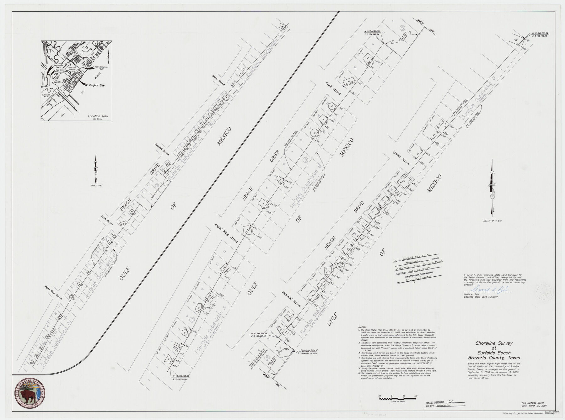
Brazoria County Rolled Sketch 51
Shoreline survey at Surfside Beach, Brazoria County, Texas
-
Map/Doc
87377
-
Collection
General Map Collection
-
Object Dates
2007/3/21 (Creation Date)
2007/7/13 (File Date)
2006/9/8 (Survey Date)
2006/11/13 (Survey Date)
-
People and Organizations
David A. Pyle (Surveyor/Engineer)
Charlie Strauch (Chainman/Field Personnel)
Chris Valle (Chainman/Field Personnel)
Willie Miles (Chainman/Field Personnel)
Michael Mokarzel (Chainman/Field Personnel)
David Holmes (Chainman/Field Personnel)
Jason Smalley (Chainman/Field Personnel)
Mark Neugebauer (Chainman/Field Personnel)
Richard Moffett (Chainman/Field Personnel)
-
Counties
Brazoria
-
Subjects
Surveying Rolled Sketch
-
Height x Width
34.8 x 46.8 inches
88.4 x 118.9 cm
-
Medium
mylar, print
-
Comments
Shoreline survey of the Mean Higher High Water line of the Gulf of Mexico at the community of Surfside Beach, Texas. Surveyed on the ground on September 8, 2006 and November 13, 2006, extending southerly from Starfish Drive to near Texas Street.
Part of: General Map Collection
Randall County Boundary File 2

Print $14.00
- Digital $50.00
Randall County Boundary File 2
Size 8.9 x 7.9 inches
Map/Doc 58111
[Sketch for Mineral Application 11108 - Greens Bayou]
![2786, [Sketch for Mineral Application 11108 - Greens Bayou], General Map Collection](https://historictexasmaps.com/wmedia_w700/maps/2786-1.tif.jpg)
Print $20.00
- Digital $50.00
[Sketch for Mineral Application 11108 - Greens Bayou]
1922
Size 46.0 x 21.0 inches
Map/Doc 2786
Donley County Sketch File 28

Print $40.00
- Digital $50.00
Donley County Sketch File 28
Size 25.7 x 9.1 inches
Map/Doc 21266
West End of Copano Bay and Town of Saint Marys, Texas

Print $40.00
- Digital $50.00
West End of Copano Bay and Town of Saint Marys, Texas
1861
Size 54.5 x 32.9 inches
Map/Doc 73428
Live Oak County Sketch File 27

Print $4.00
- Digital $50.00
Live Oak County Sketch File 27
1922
Size 14.3 x 8.7 inches
Map/Doc 30312
Flight Mission No. BRA-7M, Frame 77, Jefferson County

Print $20.00
- Digital $50.00
Flight Mission No. BRA-7M, Frame 77, Jefferson County
1953
Size 16.0 x 16.0 inches
Map/Doc 85499
The Coast of Mexico from Laguna de Esmotes to Punta Brava

Print $20.00
- Digital $50.00
The Coast of Mexico from Laguna de Esmotes to Punta Brava
Size 22.2 x 29.8 inches
Map/Doc 95920
Presidio County Rolled Sketch 131A

Print $20.00
- Digital $50.00
Presidio County Rolled Sketch 131A
1992
Size 36.0 x 45.5 inches
Map/Doc 9801
Harbor of Brazos Santiago, Texas

Print $20.00
- Digital $50.00
Harbor of Brazos Santiago, Texas
1887
Size 27.1 x 18.3 inches
Map/Doc 72994
Sutton County Working Sketch 10

Print $40.00
- Digital $50.00
Sutton County Working Sketch 10
1972
Size 71.0 x 42.9 inches
Map/Doc 62353

Moore County Sketch File 6

Print $16.00
- Digital $50.00
Moore County Sketch File 6
1902
Size 7.3 x 8.6 inches
Map/Doc 31939
You may also like
Map of the Southern and South-western States engraved to accompany Appletons' hand book of American travel

Print $20.00
- Digital $50.00
Map of the Southern and South-western States engraved to accompany Appletons' hand book of American travel
1849
Size 13.0 x 17.8 inches
Map/Doc 95902
Briscoe County Sketch File F

Print $40.00
- Digital $50.00
Briscoe County Sketch File F
1917
Size 20.9 x 19.3 inches
Map/Doc 76756
Llano County Working Sketch Graphic Index

Print $20.00
- Digital $50.00
Llano County Working Sketch Graphic Index
1943
Size 43.7 x 42.6 inches
Map/Doc 76624
Kent County Sketch File 13

Print $6.00
- Digital $50.00
Kent County Sketch File 13
1921
Size 11.1 x 8.7 inches
Map/Doc 28839
Westliches - Nordamerica

Print $20.00
- Digital $50.00
Westliches - Nordamerica
1867
Size 25.3 x 20.7 inches
Map/Doc 93753
Clay County Boundary File 1

Print $10.00
- Digital $50.00
Clay County Boundary File 1
Size 8.8 x 11.2 inches
Map/Doc 51356
Map of County Roads in Moore County

Print $20.00
- Digital $50.00
Map of County Roads in Moore County
Size 22.2 x 21.2 inches
Map/Doc 93005
Flight Mission No. DQO-1K, Frame 90, Galveston County

Print $20.00
- Digital $50.00
Flight Mission No. DQO-1K, Frame 90, Galveston County
1952
Size 18.8 x 22.6 inches
Map/Doc 84986
Lubbock County Boundary File 5

Print $2.00
- Digital $50.00
Lubbock County Boundary File 5
Size 7.2 x 8.2 inches
Map/Doc 56493
Crockett County Working Sketch 79

Print $40.00
- Digital $50.00
Crockett County Working Sketch 79
1973
Size 46.2 x 76.4 inches
Map/Doc 68412
Starr County Sketch File 30A

Print $20.00
- Digital $50.00
Starr County Sketch File 30A
1935
Size 21.2 x 23.6 inches
Map/Doc 12334
Nueces County Rolled Sketch 113A

Print $20.00
- Digital $50.00
Nueces County Rolled Sketch 113A
1972
Size 19.1 x 24.4 inches
Map/Doc 7121