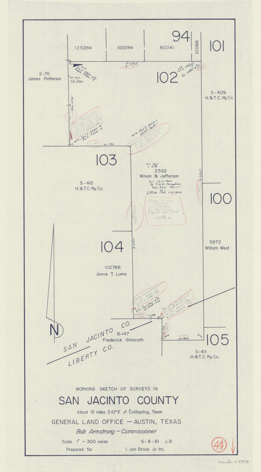
San Jacinto County Working Sketch 44
-
Map/Doc
63758
-
Collection
General Map Collection
-
Object Dates
6/8/1981 (Creation Date)
-
People and Organizations
Jana Brod (Draftsman)
-
Counties
San Jacinto
-
Subjects
Surveying Working Sketch
-
Height x Width
20.6 x 11.4 inches
52.3 x 29.0 cm
-
Scale
1" = 300 varas
Part of: General Map Collection
Kimble County Working Sketch 27

Print $20.00
- Digital $50.00
Kimble County Working Sketch 27
1934
Size 16.1 x 17.3 inches
Map/Doc 70095
Brooks County Working Sketch 18

Print $20.00
- Digital $50.00
Brooks County Working Sketch 18
1981
Size 20.6 x 32.4 inches
Map/Doc 67802
Webb County Sketch File B3

Print $40.00
- Digital $50.00
Webb County Sketch File B3
1892
Size 8.9 x 4.2 inches
Map/Doc 39658
Flight Mission No. DQN-2K, Frame 114, Calhoun County

Print $20.00
- Digital $50.00
Flight Mission No. DQN-2K, Frame 114, Calhoun County
1953
Size 18.5 x 22.2 inches
Map/Doc 84290
Crockett County Working Sketch 98

Print $20.00
- Digital $50.00
Crockett County Working Sketch 98
1980
Size 42.8 x 35.9 inches
Map/Doc 68431
Flight Mission No. BRE-2P, Frame 40, Nueces County

Print $20.00
- Digital $50.00
Flight Mission No. BRE-2P, Frame 40, Nueces County
1956
Size 18.4 x 22.4 inches
Map/Doc 86742
Andrews County Sketch File 11

Print $40.00
- Digital $50.00
Andrews County Sketch File 11
1951
Size 12.3 x 25.8 inches
Map/Doc 10811
Marion County Sketch File 17

Print $20.00
- Digital $50.00
Marion County Sketch File 17
Size 32.7 x 19.0 inches
Map/Doc 12026
Flight Mission No. CRC-3R, Frame 103, Chambers County

Print $20.00
- Digital $50.00
Flight Mission No. CRC-3R, Frame 103, Chambers County
1956
Size 18.7 x 22.4 inches
Map/Doc 84841
Bandera County Working Sketch 4

Print $20.00
- Digital $50.00
Bandera County Working Sketch 4
1914
Size 18.6 x 19.3 inches
Map/Doc 67597
Llano County Working Sketch 5

Print $20.00
- Digital $50.00
Llano County Working Sketch 5
1961
Size 43.1 x 34.4 inches
Map/Doc 70623
Pecos County Rolled Sketch 27

Print $20.00
- Digital $50.00
Pecos County Rolled Sketch 27
1890
Size 32.3 x 28.3 inches
Map/Doc 7212
You may also like
Map showing Center Lines on Holley St.

Print $3.00
- Digital $50.00
Map showing Center Lines on Holley St.
1912
Size 6.1 x 17.5 inches
Map/Doc 495
Val Verde County Working Sketch 78

Print $40.00
- Digital $50.00
Val Verde County Working Sketch 78
1972
Size 45.3 x 62.1 inches
Map/Doc 72213
Brazoria County Working Sketch 32

Print $20.00
- Digital $50.00
Brazoria County Working Sketch 32
1979
Size 15.8 x 36.9 inches
Map/Doc 67517
Plat Showing Subdivision of Wilbarger County School Land Hockley County, Texas

Print $20.00
- Digital $50.00
Plat Showing Subdivision of Wilbarger County School Land Hockley County, Texas
1947
Size 20.0 x 20.9 inches
Map/Doc 92255
Crockett County Working Sketch 58

Print $40.00
- Digital $50.00
Crockett County Working Sketch 58
1954
Size 24.3 x 54.4 inches
Map/Doc 68391
Lavaca County Working Sketch 18

Print $20.00
- Digital $50.00
Lavaca County Working Sketch 18
1979
Size 37.0 x 20.3 inches
Map/Doc 70371
Brooks County Working Sketch 16

Print $20.00
- Digital $50.00
Brooks County Working Sketch 16
1972
Size 35.0 x 29.7 inches
Map/Doc 67800
Texas Takes Shape: A History in Maps from the General Land Office

Price $48.71
Texas Takes Shape: A History in Maps from the General Land Office
Map/Doc 97432
Hansford County Boundary File 4

Print $26.00
- Digital $50.00
Hansford County Boundary File 4
Size 14.1 x 8.7 inches
Map/Doc 54279
Austin, State Capital of Texas

Digital $50.00
Austin, State Capital of Texas
1887
Size 23.0 x 32.1 inches
Map/Doc 90092
Brewster County Rolled Sketch 114

Print $20.00
- Digital $50.00
Brewster County Rolled Sketch 114
1964
Size 11.5 x 17.6 inches
Map/Doc 5274
The Republic County of Bexar. January 29, 1842

Print $20.00
The Republic County of Bexar. January 29, 1842
2020
Size 14.7 x 21.7 inches
Map/Doc 96099