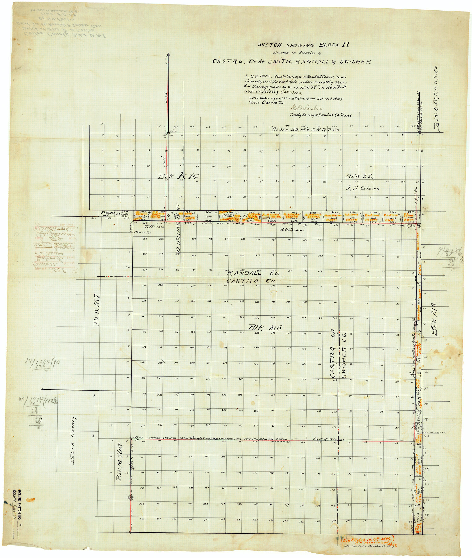
Castro County Rolled Sketch 8
Sketch showing Block R surveyed in Counties of Castro, Deaf Smith, Randall & Swisher
-
Map/Doc
5418
-
Collection
General Map Collection
-
Object Dates
1908/5/2 (File Date)
-
People and Organizations
G.G. Foster (Surveyor/Engineer)
-
Counties
Castro Deaf Smith Randall Swisher
-
Subjects
Surveying Rolled Sketch
-
Height x Width
34.1 x 28.8 inches
86.6 x 73.2 cm
-
Medium
linen, manuscript
-
Comments
See Castro County Rolled Sketches 7 (5417) and 10 (5419).
Related maps
Castro County Rolled Sketch 7

Print $20.00
- Digital $50.00
Castro County Rolled Sketch 7
1908
Size 28.9 x 24.1 inches
Map/Doc 5417
Castro County Rolled Sketch 10

Print $20.00
- Digital $50.00
Castro County Rolled Sketch 10
1908
Size 30.6 x 8.9 inches
Map/Doc 5419
Part of: General Map Collection
Palo Pinto County Rolled Sketch 13

Print $20.00
- Digital $50.00
Palo Pinto County Rolled Sketch 13
1986
Size 29.0 x 32.2 inches
Map/Doc 7193
Kaufman County Working Sketch 1

Print $20.00
- Digital $50.00
Kaufman County Working Sketch 1
1921
Size 21.4 x 47.6 inches
Map/Doc 66664
Palo Pinto County Working Sketch 7

Print $20.00
- Digital $50.00
Palo Pinto County Working Sketch 7
1922
Map/Doc 71390
Tarrant County Working Sketch 15

Print $20.00
- Digital $50.00
Tarrant County Working Sketch 15
1989
Size 33.0 x 38.3 inches
Map/Doc 62432
Moore County Working Sketch 7

Print $20.00
- Digital $50.00
Moore County Working Sketch 7
1939
Size 10.8 x 17.8 inches
Map/Doc 71189
Hood County Sketch File 7

Print $6.00
- Digital $50.00
Hood County Sketch File 7
Size 12.9 x 7.9 inches
Map/Doc 26581
[Cotton Belt, St. Louis Southwestern Railway of Texas, Alignment through Smith County]
![64379, [Cotton Belt, St. Louis Southwestern Railway of Texas, Alignment through Smith County], General Map Collection](https://historictexasmaps.com/wmedia_w700/maps/64379.tif.jpg)
Print $20.00
- Digital $50.00
[Cotton Belt, St. Louis Southwestern Railway of Texas, Alignment through Smith County]
1903
Size 22.6 x 30.1 inches
Map/Doc 64379
Hardeman County Boundary File 3

Print $18.00
- Digital $50.00
Hardeman County Boundary File 3
Size 14.1 x 8.8 inches
Map/Doc 54375
Map of the Straits of Florida and Gulf of Mexico

Print $20.00
- Digital $50.00
Map of the Straits of Florida and Gulf of Mexico
1851
Size 18.3 x 27.5 inches
Map/Doc 72673
Concho County Sketch File 53

Print $8.00
- Digital $50.00
Concho County Sketch File 53
2002
Size 11.3 x 8.9 inches
Map/Doc 78515
Atascosa County Working Sketch 14

Print $20.00
- Digital $50.00
Atascosa County Working Sketch 14
1932
Size 18.4 x 17.4 inches
Map/Doc 67210
Concho County Rolled Sketch 17

Print $20.00
- Digital $50.00
Concho County Rolled Sketch 17
1961
Size 35.2 x 26.5 inches
Map/Doc 78462
You may also like
Flight Mission No. BQR-22K, Frame 42, Brazoria County

Print $20.00
- Digital $50.00
Flight Mission No. BQR-22K, Frame 42, Brazoria County
1953
Size 18.9 x 22.7 inches
Map/Doc 84126
Smith County Working Sketch 13

Print $20.00
- Digital $50.00
Smith County Working Sketch 13
1962
Size 36.8 x 27.4 inches
Map/Doc 63898
Mason County Working Sketch 5

Print $20.00
- Digital $50.00
Mason County Working Sketch 5
1935
Size 12.1 x 18.5 inches
Map/Doc 70841
Coleman County Rolled Sketch 6

Print $20.00
- Digital $50.00
Coleman County Rolled Sketch 6
Size 20.9 x 14.4 inches
Map/Doc 5529
Map of Ochiltree County, Texas

Print $20.00
- Digital $50.00
Map of Ochiltree County, Texas
Size 17.9 x 14.6 inches
Map/Doc 4610
Maps of Gulf Intracoastal Waterway, Texas - Sabine River to the Rio Grande and connecting waterways including ship channels

Print $20.00
- Digital $50.00
Maps of Gulf Intracoastal Waterway, Texas - Sabine River to the Rio Grande and connecting waterways including ship channels
1966
Size 14.5 x 22.2 inches
Map/Doc 61963
Galveston County Rolled Sketch 44

Print $20.00
- Digital $50.00
Galveston County Rolled Sketch 44
1991
Size 25.1 x 36.8 inches
Map/Doc 5974
Flight Mission No. BRA-7M, Frame 196, Jefferson County

Print $20.00
- Digital $50.00
Flight Mission No. BRA-7M, Frame 196, Jefferson County
1953
Size 18.5 x 22.3 inches
Map/Doc 85564
Coast Chart No. 210 Aransas Pass and Corpus Christi Bay with the coast to latitude 27° 12' Texas

Print $20.00
- Digital $50.00
Coast Chart No. 210 Aransas Pass and Corpus Christi Bay with the coast to latitude 27° 12' Texas
1913
Size 27.7 x 18.3 inches
Map/Doc 72798
Flight Mission No. CRC-2R, Frame 114, Chambers County

Print $20.00
- Digital $50.00
Flight Mission No. CRC-2R, Frame 114, Chambers County
1956
Size 18.5 x 22.4 inches
Map/Doc 84741
Duval County Boundary File 1a

Print $18.00
- Digital $50.00
Duval County Boundary File 1a
Size 12.8 x 8.4 inches
Map/Doc 52670
