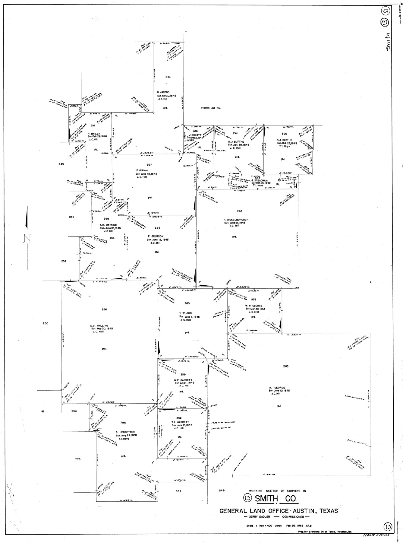
Smith County Working Sketch 13
-
Map/Doc
63898
-
Collection
General Map Collection
-
Object Dates
2/20/1962 (Creation Date)
-
Counties
Smith
-
Subjects
Surveying Working Sketch
-
Height x Width
36.8 x 27.4 inches
93.5 x 69.6 cm
-
Scale
1" = 400 varas
Part of: General Map Collection
Flight Mission No. CGI-1N, Frame 218, Cameron County

Print $20.00
- Digital $50.00
Flight Mission No. CGI-1N, Frame 218, Cameron County
1955
Size 18.6 x 22.1 inches
Map/Doc 84527
Flight Mission No. BRE-2P, Frame 15, Nueces County

Print $20.00
- Digital $50.00
Flight Mission No. BRE-2P, Frame 15, Nueces County
1956
Size 18.4 x 22.4 inches
Map/Doc 86724
Galveston Bay Entrance - Galveston and Texas City Harbors

Print $40.00
- Digital $50.00
Galveston Bay Entrance - Galveston and Texas City Harbors
1992
Size 37.1 x 55.6 inches
Map/Doc 69866
Burnet County Sketch File 3

Print $4.00
- Digital $50.00
Burnet County Sketch File 3
Size 12.3 x 8.1 inches
Map/Doc 16674
Nolan County Sketch File D1

Print $42.00
- Digital $50.00
Nolan County Sketch File D1
1904
Size 19.5 x 18.8 inches
Map/Doc 42173
Blanco County Sketch File 43

Print $6.00
- Digital $50.00
Blanco County Sketch File 43
1901
Size 9.7 x 6.2 inches
Map/Doc 14666
Taylor County Sketch File 9

Print $40.00
- Digital $50.00
Taylor County Sketch File 9
Size 14.6 x 15.8 inches
Map/Doc 37792
Kimble County Working Sketch 30

Print $20.00
- Digital $50.00
Kimble County Working Sketch 30
1942
Size 24.5 x 21.6 inches
Map/Doc 70098
Brown County Rolled Sketch 2

Print $20.00
- Digital $50.00
Brown County Rolled Sketch 2
1984
Size 42.4 x 25.2 inches
Map/Doc 5349
Burleson County Working Sketch 19

Print $20.00
- Digital $50.00
Burleson County Working Sketch 19
1980
Size 13.5 x 15.1 inches
Map/Doc 67738
Flight Mission No. CUG-1P, Frame 167, Kleberg County

Print $20.00
- Digital $50.00
Flight Mission No. CUG-1P, Frame 167, Kleberg County
1956
Size 18.7 x 22.4 inches
Map/Doc 86174
Midland County Rolled Sketch T

Print $20.00
- Digital $50.00
Midland County Rolled Sketch T
1933
Size 15.9 x 21.4 inches
Map/Doc 6772
You may also like
Kimble County Working Sketch 22

Print $20.00
- Digital $50.00
Kimble County Working Sketch 22
1929
Size 25.2 x 21.1 inches
Map/Doc 70090
Edwards County Working Sketch 92

Print $20.00
- Digital $50.00
Edwards County Working Sketch 92
1966
Size 31.8 x 47.5 inches
Map/Doc 68968
Harris County Rolled Sketch J

Print $40.00
- Digital $50.00
Harris County Rolled Sketch J
1933
Size 53.6 x 41.6 inches
Map/Doc 9122
Sketch of a reconnaissance of Aransas and Corpus Christi Bays

Print $20.00
- Digital $50.00
Sketch of a reconnaissance of Aransas and Corpus Christi Bays
1855
Size 25.5 x 18.2 inches
Map/Doc 72968
Smith County Sketch File 4

Print $4.00
- Digital $50.00
Smith County Sketch File 4
1853
Size 10.3 x 8.1 inches
Map/Doc 36752
Webb County Sketch File 6

Print $5.00
- Digital $50.00
Webb County Sketch File 6
1875
Size 7.3 x 13.7 inches
Map/Doc 39735
Whitehead Second Addition

Print $20.00
- Digital $50.00
Whitehead Second Addition
Size 11.0 x 18.6 inches
Map/Doc 92879
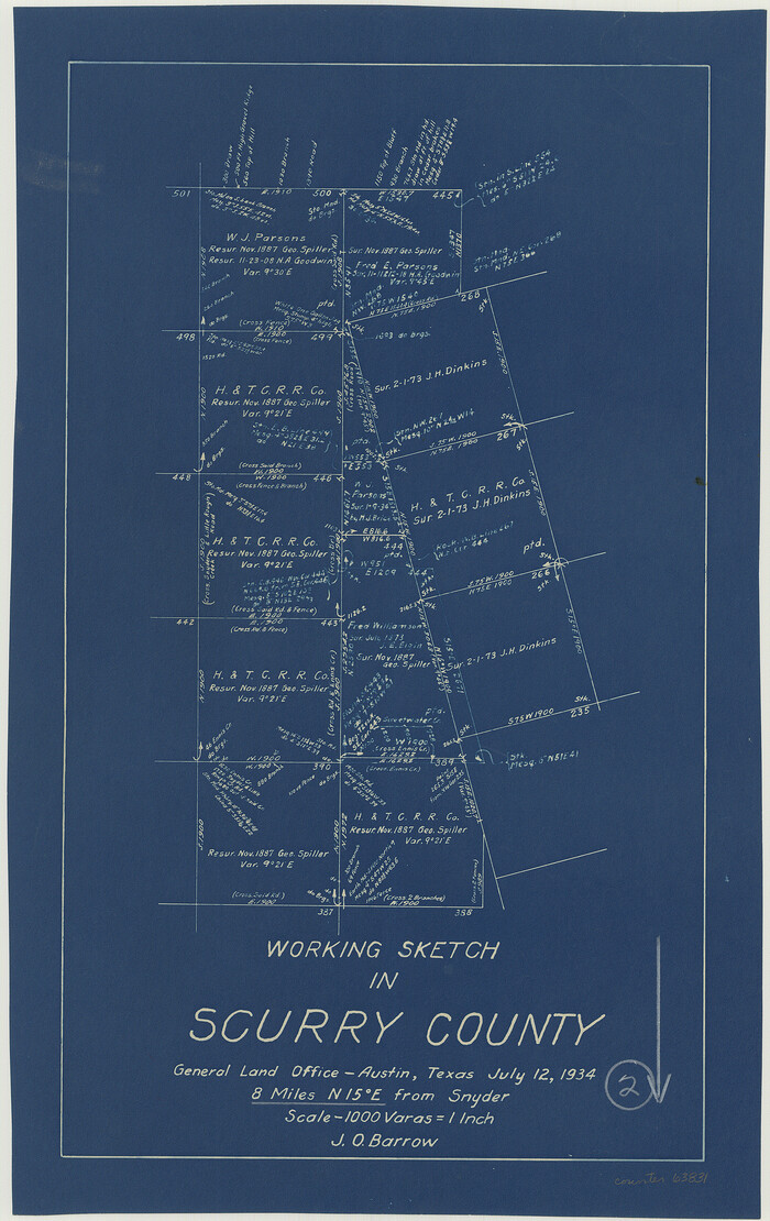
Scurry County Working Sketch 2
Print $3.00
- Digital $50.00
Scurry County Working Sketch 2
1934
Size 16.2 x 10.2 inches
Map/Doc 63831
Current Miscellaneous File 110

Print $62.00
- Digital $50.00
Current Miscellaneous File 110
1972
Size 11.1 x 8.8 inches
Map/Doc 74713
Map of Williamson County

Print $20.00
- Digital $50.00
Map of Williamson County
1876
Size 21.2 x 28.6 inches
Map/Doc 4152
[Block XR, Capitol Leagues 161, 162, 164, 174, 178, 179, and 180]
![90729, [Block XR, Capitol Leagues 161, 162, 164, 174, 178, 179, and 180], Twichell Survey Records](https://historictexasmaps.com/wmedia_w700/maps/90729-1.tif.jpg)
Print $20.00
- Digital $50.00
[Block XR, Capitol Leagues 161, 162, 164, 174, 178, 179, and 180]
1908
Size 13.1 x 21.6 inches
Map/Doc 90729
Sutton County Sketch File Ca

Print $6.00
- Digital $50.00
Sutton County Sketch File Ca
1901
Size 12.3 x 9.8 inches
Map/Doc 37382