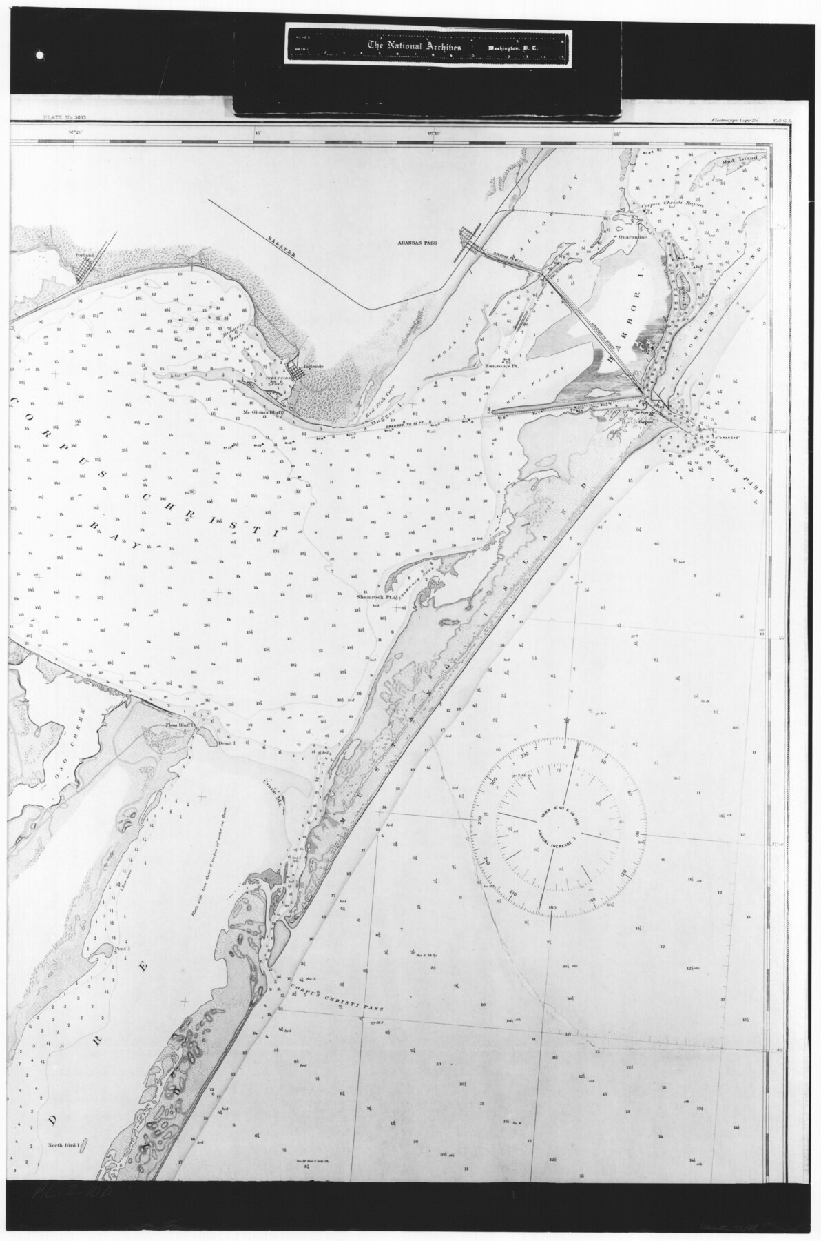
Coast Chart No. 210 Aransas Pass and Corpus Christi Bay with the coast to latitude 27° 12' Texas
RL-2-10b
-
Map/Doc
72798
-
Collection
General Map Collection
-
Object Dates
1913 (Creation Date)
-
People and Organizations
Coast and Geodetic Survey (Publisher)
-
Counties
Nueces
-
Subjects
Nautical Charts
-
Height x Width
27.7 x 18.3 inches
70.4 x 46.5 cm
-
Comments
B/W photostat copy from National Archives in multiple pieces.
Part of: General Map Collection
Wise County Working Sketch 17

Print $20.00
- Digital $50.00
Wise County Working Sketch 17
1972
Size 29.9 x 25.0 inches
Map/Doc 72631
Jasper County Boundary File 2

Print $58.00
- Digital $50.00
Jasper County Boundary File 2
Size 9.0 x 8.0 inches
Map/Doc 55469
Roberts County Working Sketch 42

Print $20.00
- Digital $50.00
Roberts County Working Sketch 42
1978
Size 26.7 x 22.7 inches
Map/Doc 63568
Map of Palo Pinto County Texas

Print $20.00
- Digital $50.00
Map of Palo Pinto County Texas
1879
Size 22.0 x 17.3 inches
Map/Doc 3933
Flight Mission No. CGI-3N, Frame 50, Cameron County

Print $20.00
- Digital $50.00
Flight Mission No. CGI-3N, Frame 50, Cameron County
1954
Size 18.6 x 22.2 inches
Map/Doc 84556
Galveston County Boundary File 32

Print $52.00
- Digital $50.00
Galveston County Boundary File 32
Size 16.7 x 13.6 inches
Map/Doc 53658
Flight Mission No. BRE-1P, Frame 28, Nueces County

Print $20.00
- Digital $50.00
Flight Mission No. BRE-1P, Frame 28, Nueces County
1956
Size 16.6 x 16.1 inches
Map/Doc 86624
Wharton County Working Sketch 8

Print $20.00
- Digital $50.00
Wharton County Working Sketch 8
1983
Size 37.2 x 32.3 inches
Map/Doc 72472
Palo Pinto County Working Sketch 5

Print $40.00
- Digital $50.00
Palo Pinto County Working Sketch 5
1920
Map/Doc 71388
Jefferson County Sketch File 6

Print $4.00
- Digital $50.00
Jefferson County Sketch File 6
1860
Size 12.3 x 7.8 inches
Map/Doc 28110
El Paso County Boundary File 7

Print $14.00
- Digital $50.00
El Paso County Boundary File 7
Size 14.0 x 8.8 inches
Map/Doc 53087
Map of Bexar County

Print $20.00
- Digital $50.00
Map of Bexar County
1845
Size 47.5 x 41.7 inches
Map/Doc 87235
You may also like
Val Verde County Rolled Sketch 76

Print $20.00
- Digital $50.00
Val Verde County Rolled Sketch 76
1976
Size 38.6 x 26.6 inches
Map/Doc 8139
Western Cotton Oil Co. Property Lamb County, Texas

Print $20.00
- Digital $50.00
Western Cotton Oil Co. Property Lamb County, Texas
1951
Size 24.1 x 19.6 inches
Map/Doc 92165
Section Q Tech Memorial Park, Inc.

Print $20.00
- Digital $50.00
Section Q Tech Memorial Park, Inc.
1950
Size 28.5 x 31.6 inches
Map/Doc 92349
Brazoria County Sketch File 15a

Print $4.00
- Digital $50.00
Brazoria County Sketch File 15a
1892
Size 14.2 x 8.7 inches
Map/Doc 14979
Howard County Sketch File 15

Print $6.00
- Digital $50.00
Howard County Sketch File 15
Size 11.2 x 8.8 inches
Map/Doc 26875
Kerr County Working Sketch 14

Print $20.00
- Digital $50.00
Kerr County Working Sketch 14
1952
Size 26.5 x 24.5 inches
Map/Doc 70045

Harris County NRC Article 33.136 Sketch 3

Print $26.00
- Digital $50.00
Harris County NRC Article 33.136 Sketch 3
2001
Size 18.6 x 24.8 inches
Map/Doc 61597
[Sketch showing Potter County Block 2] / [Sketch showing F. W. & D. C. Round House]
![91710, [Sketch showing Potter County Block 2] / [Sketch showing F. W. & D. C. Round House], Twichell Survey Records](https://historictexasmaps.com/wmedia_w700/maps/91710-1.tif.jpg)
Print $20.00
- Digital $50.00
[Sketch showing Potter County Block 2] / [Sketch showing F. W. & D. C. Round House]
Size 14.6 x 12.1 inches
Map/Doc 91710
Bee County Boundary File 6

Print $4.00
- Digital $50.00
Bee County Boundary File 6
Size 10.4 x 7.9 inches
Map/Doc 50458
Montgomery County Sketch File 11

Print $4.00
- Digital $50.00
Montgomery County Sketch File 11
1872
Size 6.7 x 7.9 inches
Map/Doc 31800
Kimble County Boundary File 2

Print $26.00
- Digital $50.00
Kimble County Boundary File 2
Size 9.6 x 6.2 inches
Map/Doc 64833