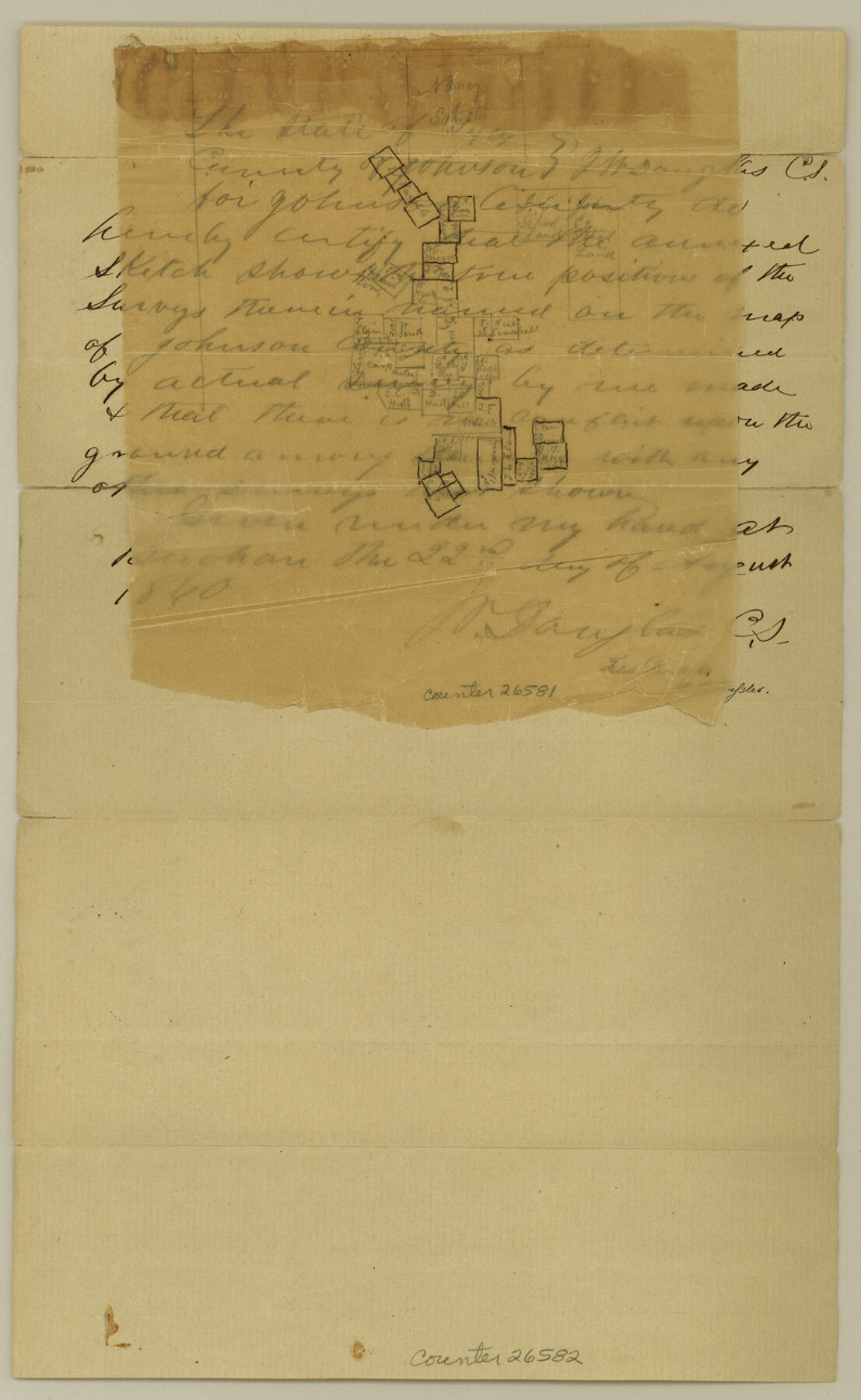
Hood County Sketch File 7
[Sketch in northeast part of county]
-
Map/Doc
26581
-
Collection
General Map Collection
-
Object Dates
12/11/1860 (File Date)
8/22/1860 (Survey Date)
-
People and Organizations
Warren Douglas (Surveyor/Engineer)
-
Counties
Hood Johnson
-
Subjects
Surveying Sketch File
-
Height x Width
12.9 x 7.9 inches
32.8 x 20.1 cm
-
Medium
paper, manuscript
Part of: General Map Collection
Denton County Working Sketch 21

Print $20.00
- Digital $50.00
Denton County Working Sketch 21
1983
Size 37.3 x 35.8 inches
Map/Doc 68626
Harris County Working Sketch 100

Print $20.00
- Digital $50.00
Harris County Working Sketch 100
1979
Size 29.9 x 31.3 inches
Map/Doc 65992
Trinity River, Bazzette Sheet

Print $20.00
- Digital $50.00
Trinity River, Bazzette Sheet
1925
Size 27.9 x 23.8 inches
Map/Doc 78339
Clay County Sketch File 33

Print $4.00
- Digital $50.00
Clay County Sketch File 33
Size 12.0 x 7.6 inches
Map/Doc 18459
Refugio County Boundary File 2

Print $32.00
- Digital $50.00
Refugio County Boundary File 2
Size 14.1 x 8.8 inches
Map/Doc 58233
Johnson County Working Sketch 10

Print $20.00
- Digital $50.00
Johnson County Working Sketch 10
1953
Size 26.2 x 37.1 inches
Map/Doc 66623
Texas, Corpus Christi, Corpus Christi to Laguna Madre

Print $40.00
- Digital $50.00
Texas, Corpus Christi, Corpus Christi to Laguna Madre
1934
Size 35.1 x 48.6 inches
Map/Doc 73457
[Map of] North America
![88884, [Map of] North America, General Map Collection](https://historictexasmaps.com/wmedia_w700/maps/88884.tif.jpg)
Print $3.00
- Digital $50.00
[Map of] North America
1834
Size 11.0 x 8.5 inches
Map/Doc 88884
Howard County Sketch File A

Print $44.00
- Digital $50.00
Howard County Sketch File A
Size 7.2 x 7.6 inches
Map/Doc 26837
Spanish and Mexican Land Grants in Texas

Print $20.00
Spanish and Mexican Land Grants in Texas
2015
Size 34.0 x 44.0 inches
Map/Doc 93755
Ward County Working Sketch 46

Print $20.00
- Digital $50.00
Ward County Working Sketch 46
1974
Size 35.0 x 38.3 inches
Map/Doc 72352
Clay County Working Sketch 2

Print $20.00
- Digital $50.00
Clay County Working Sketch 2
1907
Size 26.5 x 16.2 inches
Map/Doc 68025
You may also like
Working Sketch No. II in Pecos County

Print $20.00
- Digital $50.00
Working Sketch No. II in Pecos County
1886
Size 31.3 x 24.1 inches
Map/Doc 3953
Potter County Working Sketch 2

Print $40.00
- Digital $50.00
Potter County Working Sketch 2
1919
Size 43.3 x 54.4 inches
Map/Doc 71662
Sketch in Crockett County, Texas

Print $20.00
- Digital $50.00
Sketch in Crockett County, Texas
1924
Size 34.4 x 47.8 inches
Map/Doc 92606
Burleson County Working Sketch 12

Print $20.00
- Digital $50.00
Burleson County Working Sketch 12
1980
Size 20.6 x 12.0 inches
Map/Doc 67731
Panola County Rolled Sketch 4A

Print $40.00
- Digital $50.00
Panola County Rolled Sketch 4A
1953
Size 50.0 x 24.8 inches
Map/Doc 9677
Flight Mission No. CGN-3P, Frame 141, San Patricio County

Print $20.00
- Digital $50.00
Flight Mission No. CGN-3P, Frame 141, San Patricio County
1956
Size 18.6 x 22.4 inches
Map/Doc 86985
Bandera County Rolled Sketch 9

Print $20.00
- Digital $50.00
Bandera County Rolled Sketch 9
Size 21.2 x 24.2 inches
Map/Doc 5120
G.C. & S.F. Ry. Alinement and Right of Way map of Dallas Branch, Ellis County, Texas

Print $40.00
- Digital $50.00
G.C. & S.F. Ry. Alinement and Right of Way map of Dallas Branch, Ellis County, Texas
1925
Size 31.4 x 120.7 inches
Map/Doc 64547
Limestone Co.

Print $20.00
- Digital $50.00
Limestone Co.
1971
Size 40.6 x 27.5 inches
Map/Doc 77354
Gaines County Working Sketch 20

Print $20.00
- Digital $50.00
Gaines County Working Sketch 20
1970
Size 44.2 x 44.1 inches
Map/Doc 69320
[Sections 69-84 Block 47 and part of Block 3]
![91795, [Sections 69-84 Block 47 and part of Block 3], Twichell Survey Records](https://historictexasmaps.com/wmedia_w700/maps/91795-1.tif.jpg)
Print $2.00
- Digital $50.00
[Sections 69-84 Block 47 and part of Block 3]
Size 14.3 x 8.9 inches
Map/Doc 91795
Located Line of the Panhandle & Gulf Ry. through State Lands, Public School and University, Right of Way 200 feet wide, in Brewster County, Texas.

Print $40.00
- Digital $50.00
Located Line of the Panhandle & Gulf Ry. through State Lands, Public School and University, Right of Way 200 feet wide, in Brewster County, Texas.
1904
Size 14.8 x 99.1 inches
Map/Doc 64059