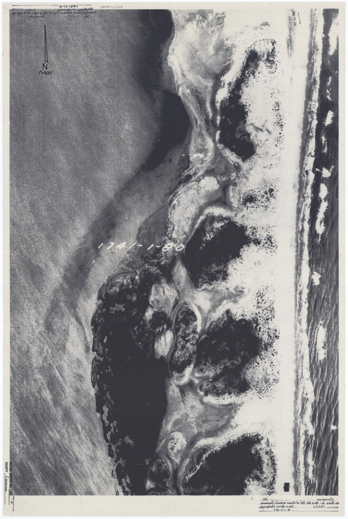
Cameron County Rolled Sketch 30
[Aerial photograph of South Padre Island Park Road 100 at Queen Isabella Causeway]
-
Map/Doc
5394
-
Collection
General Map Collection
-
Object Dates
1930 (Creation Date)
1987/9/17 (File Date)
-
Counties
Cameron
-
Subjects
Aerial Photograph Surveying Rolled Sketch
-
Height x Width
36.3 x 24.4 inches
92.2 x 62.0 cm
-
Medium
photograph
-
Comments
See Cameron County Sketch File 10 (17205) for related correspondence.
Related maps
Cameron County Sketch File 10

Print $8.00
- Digital $50.00
Cameron County Sketch File 10
1989
Size 11.1 x 8.6 inches
Map/Doc 17205
Part of: General Map Collection
Parker County Sketch File 12

Print $4.00
- Digital $50.00
Parker County Sketch File 12
1858
Size 9.1 x 7.1 inches
Map/Doc 33544
Franklin County Sketch File 7

Print $6.00
- Digital $50.00
Franklin County Sketch File 7
1852
Size 8.1 x 10.1 inches
Map/Doc 23020
Points of Interest & Road Map of Scenicland, U.S.A. and United States [Recto]
![94192, Points of Interest & Road Map of Scenicland, U.S.A. and United States [Recto], General Map Collection](https://historictexasmaps.com/wmedia_w700/maps/94192.tif.jpg)
Points of Interest & Road Map of Scenicland, U.S.A. and United States [Recto]
1966
Size 34.7 x 22.4 inches
Map/Doc 94192

Hale County Sketch File 10

Print $6.00
- Digital $50.00
Hale County Sketch File 10
1895
Size 16.3 x 9.4 inches
Map/Doc 24737
A New Map of the Whole Continent of America. Divided into North and South and West Indies, wherein are exactly decribed the United States of North America as well as the Several European Possessions according to the Preliminaries of Peace…

Print $40.00
- Digital $50.00
A New Map of the Whole Continent of America. Divided into North and South and West Indies, wherein are exactly decribed the United States of North America as well as the Several European Possessions according to the Preliminaries of Peace…
Size 22.0 x 48.3 inches
Map/Doc 95135
Map of Encinal County

Print $20.00
- Digital $50.00
Map of Encinal County
1872
Size 30.5 x 20.3 inches
Map/Doc 3513
Part of Laguna Madre in Cameron County, showing Subdivision for Mineral Development

Print $20.00
- Digital $50.00
Part of Laguna Madre in Cameron County, showing Subdivision for Mineral Development
1953
Size 33.0 x 21.9 inches
Map/Doc 1927
Fort Bend County Rolled Sketch 6

Print $20.00
- Digital $50.00
Fort Bend County Rolled Sketch 6
1967
Size 26.1 x 35.4 inches
Map/Doc 5897


Harris County Historic Topographic 27

Print $20.00
- Digital $50.00
Harris County Historic Topographic 27
1915
Size 19.8 x 23.5 inches
Map/Doc 65838
You may also like
Palo Pinto County Sketch File 6

Print $40.00
- Digital $50.00
Palo Pinto County Sketch File 6
1875
Size 9.3 x 18.8 inches
Map/Doc 33396
Sabine County Working Sketch 10

Print $20.00
- Digital $50.00
Sabine County Working Sketch 10
1925
Size 18.6 x 24.2 inches
Map/Doc 63681
The Judicial District/County of Spring Creek. Created, January 21, 1841

Print $20.00
The Judicial District/County of Spring Creek. Created, January 21, 1841
2020
Size 15.7 x 21.7 inches
Map/Doc 96348
Leon County Working Sketch 23

Print $20.00
- Digital $50.00
Leon County Working Sketch 23
1965
Size 14.2 x 29.7 inches
Map/Doc 70422
Sketch of a reconnaissance of Aransas and Corpus Christi Bays

Print $20.00
- Digital $50.00
Sketch of a reconnaissance of Aransas and Corpus Christi Bays
1855
Size 25.7 x 18.3 inches
Map/Doc 72969
Section A, Tech Memorial Park, Inc.

Print $20.00
- Digital $50.00
Section A, Tech Memorial Park, Inc.
Size 21.6 x 15.6 inches
Map/Doc 92785
Real County Rolled Sketch 7

Print $20.00
- Digital $50.00
Real County Rolled Sketch 7
Size 24.5 x 29.9 inches
Map/Doc 7457
Dimmit County Working Sketch 44

Print $20.00
- Digital $50.00
Dimmit County Working Sketch 44
1979
Size 31.7 x 34.0 inches
Map/Doc 68705
Erath County Working Sketch 43

Print $20.00
- Digital $50.00
Erath County Working Sketch 43
1981
Size 19.6 x 15.7 inches
Map/Doc 69124
Jack County Sketch File 18c

Print $60.00
- Digital $50.00
Jack County Sketch File 18c
Size 20.0 x 30.7 inches
Map/Doc 11828
Liberty County Sketch File 6a

Print $2.00
- Digital $50.00
Liberty County Sketch File 6a
1859
Size 7.5 x 8.4 inches
Map/Doc 29896
Map of Texas with population and location of principal towns and cities according to latest reliable statistics

Print $20.00
- Digital $50.00
Map of Texas with population and location of principal towns and cities according to latest reliable statistics
1908
Size 18.5 x 20.4 inches
Map/Doc 95873