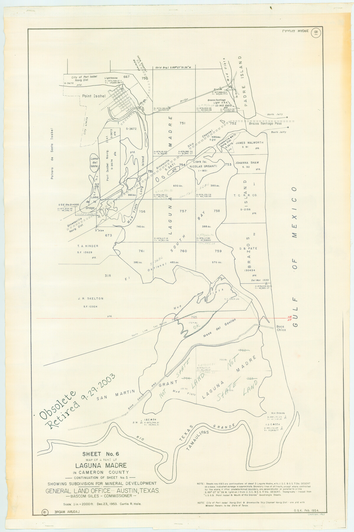
Part of Laguna Madre in Cameron County, showing Subdivision for Mineral Development
Map of A Part of Laguna Madre in Cameron County, Continuation of Sheet 5
-
Map/Doc
1927
-
Collection
General Map Collection
-
Object Dates
1953 (Creation Date)
-
People and Organizations
General Land Office (Publisher)
C.R. Hale (Compiler)
-
Counties
Cameron
-
Subjects
Energy Offshore Submerged Area
-
Height x Width
33.0 x 21.9 inches
83.8 x 55.6 cm
-
Medium
blueline cloth
-
Scale
2000 feet
-
Comments
Gulf coast and submerged state lands.
Part of: General Map Collection
Donley County Sketch File 10

Print $8.00
- Digital $50.00
Donley County Sketch File 10
1889
Size 9.6 x 6.1 inches
Map/Doc 21240
Upton County Rolled Sketch 59

Print $40.00
- Digital $50.00
Upton County Rolled Sketch 59
1994
Size 36.3 x 49.0 inches
Map/Doc 10638
Flight Mission No. BRA-9M, Frame 59, Jefferson County

Print $20.00
- Digital $50.00
Flight Mission No. BRA-9M, Frame 59, Jefferson County
1953
Size 18.6 x 22.4 inches
Map/Doc 85642
Flight Mission No. CGN-3P, Frame 23, San Patricio County

Print $20.00
- Digital $50.00
Flight Mission No. CGN-3P, Frame 23, San Patricio County
1956
Size 18.6 x 22.2 inches
Map/Doc 86981
Harris County Working Sketch 78

Print $20.00
- Digital $50.00
Harris County Working Sketch 78
1968
Size 32.8 x 25.8 inches
Map/Doc 65970
Presidio County Sketch File 105

Print $20.00
- Digital $50.00
Presidio County Sketch File 105
Size 13.1 x 20.6 inches
Map/Doc 82962
Trinity County Working Sketch 10

Print $20.00
- Digital $50.00
Trinity County Working Sketch 10
1948
Size 25.7 x 24.6 inches
Map/Doc 69459
Grimes County Sketch File 4a

Print $6.00
- Digital $50.00
Grimes County Sketch File 4a
1873
Size 13.0 x 8.4 inches
Map/Doc 24656
Anderson County Working Sketch 26

Print $20.00
- Digital $50.00
Anderson County Working Sketch 26
1959
Size 31.6 x 43.1 inches
Map/Doc 67026
Kleberg County Rolled Sketch 10-16

Print $20.00
- Digital $50.00
Kleberg County Rolled Sketch 10-16
1952
Size 37.0 x 33.2 inches
Map/Doc 9381
Bexar County State Real Property Sketch 4

Print $20.00
- Digital $50.00
Bexar County State Real Property Sketch 4
2013
Size 25.0 x 36.5 inches
Map/Doc 93692
DeWitt County Rolled Sketch 1

Print $20.00
- Digital $50.00
DeWitt County Rolled Sketch 1
1940
Size 40.5 x 39.5 inches
Map/Doc 8777
You may also like
Aransas County Rolled Sketch 28

Print $20.00
- Digital $50.00
Aransas County Rolled Sketch 28
1987
Size 24.5 x 30.9 inches
Map/Doc 77496
United States - Gulf Coast Texas - Northern part of Laguna Madre

Print $20.00
- Digital $50.00
United States - Gulf Coast Texas - Northern part of Laguna Madre
1923
Size 26.6 x 18.3 inches
Map/Doc 72931
Schleicher County

Print $20.00
- Digital $50.00
Schleicher County
1898
Size 23.1 x 36.3 inches
Map/Doc 615
Gray County Boundary File 3

Print $40.00
- Digital $50.00
Gray County Boundary File 3
Size 14.2 x 8.8 inches
Map/Doc 53854
Map of Comanche County

Print $20.00
Map of Comanche County
1876
Size 28.0 x 24.1 inches
Map/Doc 88919
Presidio County Rolled Sketch 71

Print $20.00
- Digital $50.00
Presidio County Rolled Sketch 71
1941
Size 31.7 x 42.9 inches
Map/Doc 7361
[South Part of Terrell County, West Part of Val Verde County]
![91960, [South Part of Terrell County, West Part of Val Verde County], Twichell Survey Records](https://historictexasmaps.com/wmedia_w700/maps/91960-1.tif.jpg)
Print $20.00
- Digital $50.00
[South Part of Terrell County, West Part of Val Verde County]
Size 38.6 x 18.5 inches
Map/Doc 91960
Jim Hogg County Working Sketch 5

Print $20.00
- Digital $50.00
Jim Hogg County Working Sketch 5
1941
Size 40.8 x 41.0 inches
Map/Doc 66591
Hays County Sketch File 13a

Print $40.00
- Digital $50.00
Hays County Sketch File 13a
Size 12.3 x 15.0 inches
Map/Doc 26223
Parmer County

Print $20.00
- Digital $50.00
Parmer County
1926
Size 43.9 x 35.4 inches
Map/Doc 73259
Dawson County Rolled Sketch 4

Print $20.00
- Digital $50.00
Dawson County Rolled Sketch 4
Size 24.3 x 23.9 inches
Map/Doc 5690
Martin County Sketch File 14

Print $46.00
- Digital $50.00
Martin County Sketch File 14
1937
Size 11.2 x 8.8 inches
Map/Doc 30671