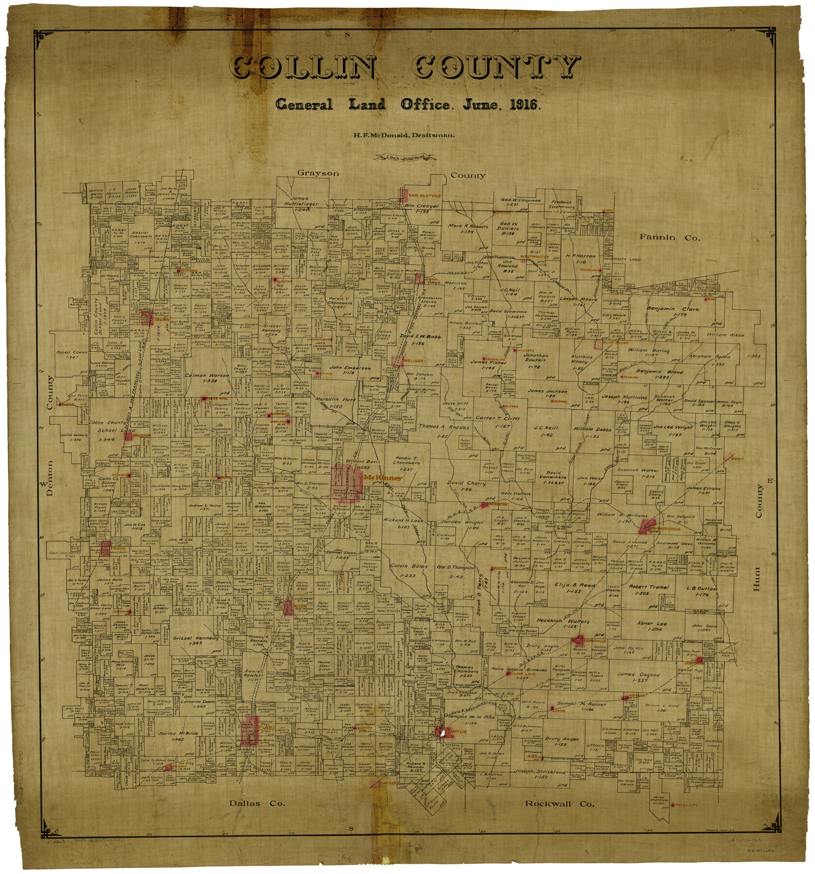
Collin County
-
Map/Doc
4914
-
Collection
General Map Collection
-
Object Dates
6/1916 (Creation Date)
-
People and Organizations
H.F. McDonald (Draftsman)
-
Counties
Collin
-
Subjects
County
-
Height x Width
42.3 x 38.9 inches
107.4 x 98.8 cm
Part of: General Map Collection
Hansford County Sketch File 13

Print $12.00
- Digital $50.00
Hansford County Sketch File 13
1989
Size 11.2 x 8.8 inches
Map/Doc 24978
Matagorda County NRC Article 33.136 Sketch 3

Print $20.00
- Digital $50.00
Matagorda County NRC Article 33.136 Sketch 3
2008
Size 36.0 x 24.0 inches
Map/Doc 88834
Polk County Sketch File 25

Print $46.00
- Digital $50.00
Polk County Sketch File 25
Size 5.7 x 28.2 inches
Map/Doc 34176
Galveston County Sketch File 69

Print $226.00
- Digital $50.00
Galveston County Sketch File 69
1884
Size 14.4 x 9.0 inches
Map/Doc 23815
El Paso County Rolled Sketch 10

Print $93.00
- Digital $50.00
El Paso County Rolled Sketch 10
1883
Size 42.4 x 61.3 inches
Map/Doc 8853
El Paso County

Print $40.00
- Digital $50.00
El Paso County
1881
Size 53.7 x 88.3 inches
Map/Doc 16826
Flight Mission No. DQN-2K, Frame 26, Calhoun County

Print $20.00
- Digital $50.00
Flight Mission No. DQN-2K, Frame 26, Calhoun County
1953
Size 18.6 x 22.2 inches
Map/Doc 84233
Concho County Sketch File 8 1/4

Print $20.00
- Digital $50.00
Concho County Sketch File 8 1/4
Size 23.4 x 15.0 inches
Map/Doc 11149

Terrell County Working Sketch 29

Print $20.00
- Digital $50.00
Terrell County Working Sketch 29
1944
Size 28.6 x 35.5 inches
Map/Doc 62121
Gaines County Rolled Sketch 20

Print $20.00
- Digital $50.00
Gaines County Rolled Sketch 20
1955
Size 30.1 x 37.2 inches
Map/Doc 5936
Dallas, Ft. Worth, & Vicinity, Texas - Regional Map

Dallas, Ft. Worth, & Vicinity, Texas - Regional Map
1997
Size 25.7 x 36.7 inches
Map/Doc 97289
You may also like
Tyler County Working Sketch Graphic Index

Print $20.00
- Digital $50.00
Tyler County Working Sketch Graphic Index
1944
Size 47.4 x 39.6 inches
Map/Doc 76719
Galveston County NRC Article 33.136 Sketch 3

Print $20.00
- Digital $50.00
Galveston County NRC Article 33.136 Sketch 3
2001
Size 22.4 x 34.0 inches
Map/Doc 61567
Montgomery County Sketch File 36

Print $40.00
- Digital $50.00
Montgomery County Sketch File 36
1953
Size 51.7 x 34.9 inches
Map/Doc 10551

Map of Young County East of the Main Brazos River formerly Fannin and West of it Milam Land District

Print $20.00
- Digital $50.00
Map of Young County East of the Main Brazos River formerly Fannin and West of it Milam Land District
1859
Size 23.3 x 20.2 inches
Map/Doc 4173
Map of Galveston Bay from Lawrence Cove to Stevenson's Station

Print $20.00
- Digital $50.00
Map of Galveston Bay from Lawrence Cove to Stevenson's Station
1851
Size 41.5 x 30.0 inches
Map/Doc 69922
Galveston County Aerial Photograph Index Sheet 1

Print $20.00
- Digital $50.00
Galveston County Aerial Photograph Index Sheet 1
1953
Size 23.4 x 19.2 inches
Map/Doc 83692
Calhoun County Rolled Sketch 13

Print $20.00
- Digital $50.00
Calhoun County Rolled Sketch 13
1948
Size 43.0 x 41.0 inches
Map/Doc 8547
Williamson County Sketch File 10

Print $22.00
- Digital $50.00
Williamson County Sketch File 10
1858
Size 12.2 x 17.1 inches
Map/Doc 40322
Stephens County Working Sketch 5

Print $20.00
- Digital $50.00
Stephens County Working Sketch 5
1919
Size 24.8 x 25.3 inches
Map/Doc 63948
Orange County Working Sketch 51

Print $20.00
- Digital $50.00
Orange County Working Sketch 51
1992
Size 29.6 x 22.0 inches
Map/Doc 71383
General Highway Map, Oldham County, Texas

Print $20.00
General Highway Map, Oldham County, Texas
1961
Size 24.6 x 18.2 inches
Map/Doc 79620