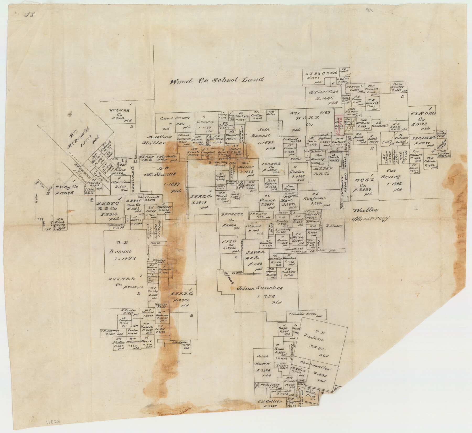
Jack County Sketch File 18c
Hill's off. Sketch of surs. Around the Julian Sanchez
-
Map/Doc
11828
-
Collection
General Map Collection
-
People and Organizations
Hill (Surveyor/Engineer)
-
Counties
Jack
-
Subjects
Surveying Sketch File
-
Height x Width
20.0 x 30.7 inches
50.8 x 78.0 cm
-
Medium
paper, manuscript
Part of: General Map Collection
Mason County Sketch File 22

Print $8.00
- Digital $50.00
Mason County Sketch File 22
1932
Size 11.1 x 8.9 inches
Map/Doc 30719
Loving County Working Sketch 23

Print $20.00
- Digital $50.00
Loving County Working Sketch 23
1952
Size 15.1 x 31.5 inches
Map/Doc 70657
Clay County Sketch File 19

Print $5.00
- Digital $50.00
Clay County Sketch File 19
Size 9.2 x 9.9 inches
Map/Doc 18429

DeWitt County Rolled Sketch 2

Print $20.00
- Digital $50.00
DeWitt County Rolled Sketch 2
1943
Size 32.0 x 42.7 inches
Map/Doc 8778
Mason County Sketch File 17a

Print $6.00
- Digital $50.00
Mason County Sketch File 17a
1887
Size 10.3 x 10.9 inches
Map/Doc 30707
Terrell County Rolled Sketch W

Print $20.00
- Digital $50.00
Terrell County Rolled Sketch W
Size 15.4 x 14.3 inches
Map/Doc 7979
Montgomery County Sketch File 16

Print $26.00
- Digital $50.00
Montgomery County Sketch File 16
1896
Size 14.2 x 8.8 inches
Map/Doc 31819
Potter County Sketch File 20

Print $4.00
- Digital $50.00
Potter County Sketch File 20
Size 12.2 x 8.7 inches
Map/Doc 34411
Chambers County Boundary File 3

Print $112.00
- Digital $50.00
Chambers County Boundary File 3
Size 52.5 x 3.9 inches
Map/Doc 51249
Pecos County Working Sketch 43

Print $40.00
- Digital $50.00
Pecos County Working Sketch 43
1943
Size 19.5 x 50.7 inches
Map/Doc 71515
Jack County Working Sketch 10

Print $20.00
- Digital $50.00
Jack County Working Sketch 10
1955
Size 24.4 x 18.6 inches
Map/Doc 66436
You may also like
Hidalgo County Rolled Sketch 17

Print $40.00
- Digital $50.00
Hidalgo County Rolled Sketch 17
1963
Size 68.4 x 42.9 inches
Map/Doc 9172
Working Sketch in Bastrop County

Print $20.00
- Digital $50.00
Working Sketch in Bastrop County
1923
Size 19.9 x 14.8 inches
Map/Doc 90238
[William Steele Survey near Copano Bay]
![2082, [William Steele Survey near Copano Bay], General Map Collection](https://historictexasmaps.com/wmedia_w700/maps/2082.tif.jpg)
Print $20.00
- Digital $50.00
[William Steele Survey near Copano Bay]
1927
Size 26.1 x 18.4 inches
Map/Doc 2082
Flight Mission No. DQO-12K, Frame 35, Galveston County

Print $20.00
- Digital $50.00
Flight Mission No. DQO-12K, Frame 35, Galveston County
1952
Size 18.7 x 22.4 inches
Map/Doc 85226
Nueces County Rolled Sketch 50

Print $20.00
- Digital $50.00
Nueces County Rolled Sketch 50
1939
Size 21.9 x 38.0 inches
Map/Doc 9605
Flight Mission No. CUG-2P, Frame 69, Kleberg County

Print $20.00
- Digital $50.00
Flight Mission No. CUG-2P, Frame 69, Kleberg County
1956
Size 18.4 x 22.2 inches
Map/Doc 86206
Montgomery County Sketch File 5

Print $5.00
- Digital $50.00
Montgomery County Sketch File 5
Size 9.8 x 16.4 inches
Map/Doc 31779
Potter County Working Sketch 2

Print $40.00
- Digital $50.00
Potter County Working Sketch 2
1919
Size 43.3 x 54.4 inches
Map/Doc 71662
Map of Galveston, Turtle & East Bays & portions of the Gulf of Mexico in Chambers & Galveston Counties, Texas showing subdivision for mineral development

Print $40.00
- Digital $50.00
Map of Galveston, Turtle & East Bays & portions of the Gulf of Mexico in Chambers & Galveston Counties, Texas showing subdivision for mineral development
Size 50.0 x 55.2 inches
Map/Doc 65807
Dickens County Sketch File 32

Print $20.00
- Digital $50.00
Dickens County Sketch File 32
Size 32.8 x 30.6 inches
Map/Doc 11328
[T. & N. O. R.R. Jefferson Co. North]
![64055, [T. & N. O. R.R. Jefferson Co. North], General Map Collection](https://historictexasmaps.com/wmedia_w700/maps/64055.tif.jpg)
Print $20.00
- Digital $50.00
[T. & N. O. R.R. Jefferson Co. North]
Size 13.4 x 33.4 inches
Map/Doc 64055
Comal County Sketch File 3b

Print $20.00
- Digital $50.00
Comal County Sketch File 3b
1847
Size 12.4 x 16.1 inches
Map/Doc 19003