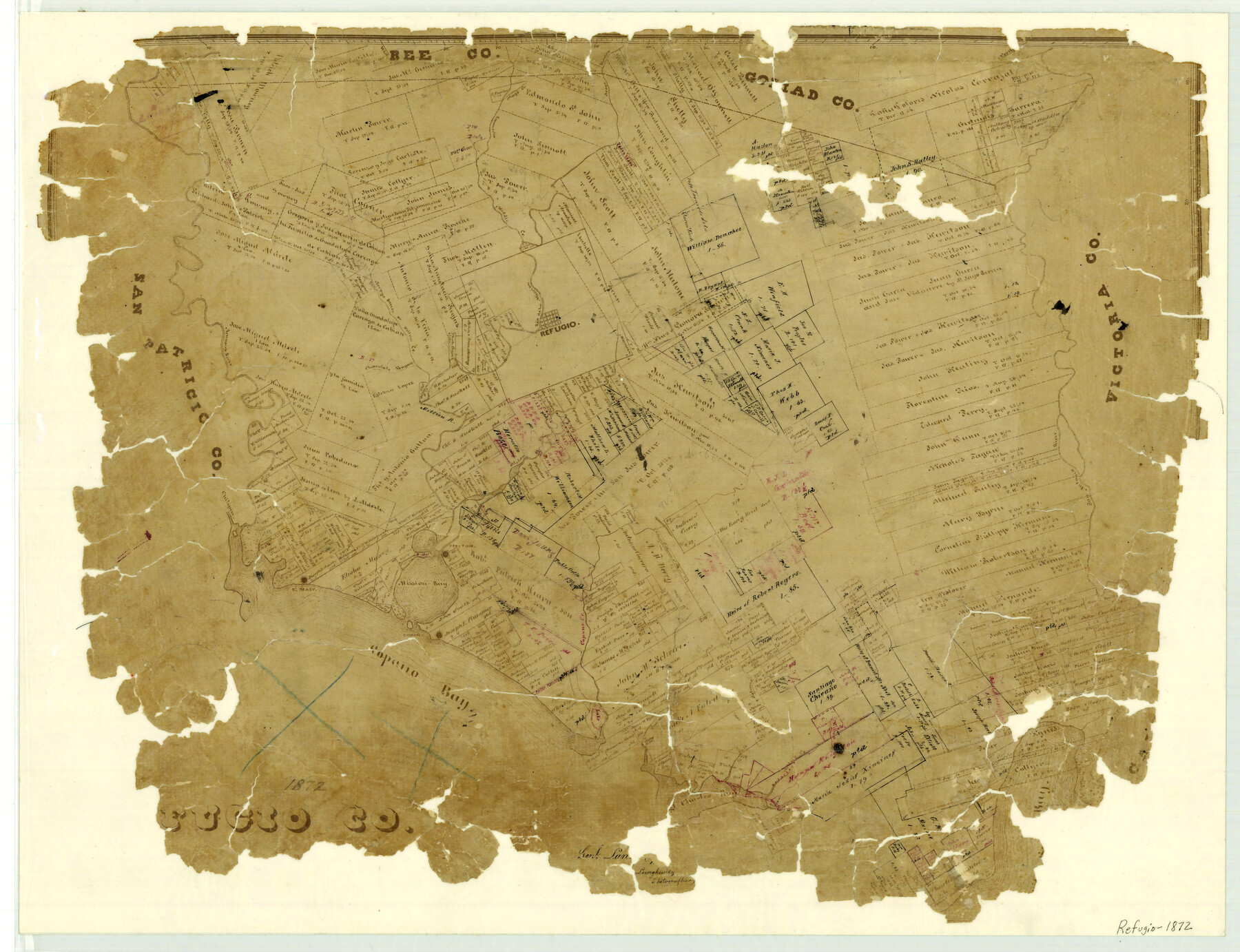
Refugio County
-
Map/Doc
3987
-
Collection
General Map Collection
-
Object Dates
1872 (Creation Date)
-
People and Organizations
Texas General Land Office (Publisher)
Herman Lungkwitz (Draftsman)
-
Counties
Refugio
-
Subjects
County
-
Height x Width
17.6 x 22.9 inches
44.7 x 58.2 cm
-
Features
Mission Bay
Salt Creek
San Antonio River
Rio de la Mission
Burgentine Creek
St. Charles Bay
Hynes Bay
Copano Bay
Salinas Creek
Copano Creek
Copano
Chiltipin
St. Mary
Mays Creek
Preston
Melon Lake
Goose Lake
Mission River
Aransas River
Chocolate Bayou
Willow Creek
Arroyo Sous
Refugio
Middle Creek
Emmedio Creek
Aroyo [sic] Blanco
Part of: General Map Collection
Padre Island National Seashore

Print $4.00
- Digital $50.00
Padre Island National Seashore
Size 16.0 x 21.9 inches
Map/Doc 60526
Jefferson County Rolled Sketch 26

Print $40.00
- Digital $50.00
Jefferson County Rolled Sketch 26
Size 28.4 x 56.4 inches
Map/Doc 9291
Corpus Christi Bay

Print $20.00
- Digital $50.00
Corpus Christi Bay
1973
Size 36.6 x 47.7 inches
Map/Doc 73474
Pecos County Sketch File 33

Print $40.00
- Digital $50.00
Pecos County Sketch File 33
1935
Size 8.9 x 20.7 inches
Map/Doc 33712
Map of the Fort Worth & Denver City Railway, Oldham County, Texas

Print $40.00
- Digital $50.00
Map of the Fort Worth & Denver City Railway, Oldham County, Texas
1887
Size 24.8 x 105.2 inches
Map/Doc 64456
Cherokee County Working Sketch 14

Print $40.00
- Digital $50.00
Cherokee County Working Sketch 14
1957
Size 44.9 x 61.1 inches
Map/Doc 67969
Terry County Boundary File 2a

Print $32.00
- Digital $50.00
Terry County Boundary File 2a
Size 11.6 x 8.9 inches
Map/Doc 59209
Stephens County Working Sketch 24

Print $20.00
- Digital $50.00
Stephens County Working Sketch 24
1976
Size 39.2 x 31.9 inches
Map/Doc 63967
Atascosa County Sketch File 11

Print $4.00
- Digital $50.00
Atascosa County Sketch File 11
1856
Size 10.8 x 8.6 inches
Map/Doc 13767
Guadalupe County Sketch File 15d

Print $4.00
- Digital $50.00
Guadalupe County Sketch File 15d
Size 10.1 x 8.1 inches
Map/Doc 24705
Montgomery County Sketch File 41

Print $8.00
- Digital $50.00
Montgomery County Sketch File 41
2004
Size 14.0 x 8.5 inches
Map/Doc 82447
Map of North America engraved to illustrate Mitchell's school and family geography

Print $20.00
- Digital $50.00
Map of North America engraved to illustrate Mitchell's school and family geography
1839
Size 11.8 x 9.5 inches
Map/Doc 93493
You may also like
Maps & Lists Showing Prison Lands (Oil & Gas) Leased as of June 1955

Digital $50.00
Maps & Lists Showing Prison Lands (Oil & Gas) Leased as of June 1955
Size 11.1 x 9.0 inches
Map/Doc 62872
Stieler Map of 1879

Print $4.00
- Digital $50.00
Stieler Map of 1879
1879
Size 28.9 x 23.0 inches
Map/Doc 76055
Jack County Sketch File 4

Print $4.00
- Digital $50.00
Jack County Sketch File 4
1857
Size 9.0 x 12.7 inches
Map/Doc 27506
[Caddo Lake Area]
![91389, [Caddo Lake Area], Twichell Survey Records](https://historictexasmaps.com/wmedia_w700/maps/91389-1.tif.jpg)
Print $20.00
- Digital $50.00
[Caddo Lake Area]
1918
Size 28.4 x 35.3 inches
Map/Doc 91389
Brewster County Working Sketch 65

Print $20.00
- Digital $50.00
Brewster County Working Sketch 65
1958
Size 40.2 x 34.8 inches
Map/Doc 67666
[Aaron Cherry and A. M. de Lejarza Surveys on the Trinity River]
![91080, [Aaron Cherry and A. M. de Lejarza Surveys on the Trinity River], Twichell Survey Records](https://historictexasmaps.com/wmedia_w700/maps/91080-1.tif.jpg)
Print $20.00
- Digital $50.00
[Aaron Cherry and A. M. de Lejarza Surveys on the Trinity River]
Size 26.3 x 14.1 inches
Map/Doc 91080
Texas Highway Map Points of Interest, Recreational Facilities Guide, Special Events Calendar [Recto]
![94187, Texas Highway Map Points of Interest, Recreational Facilities Guide, Special Events Calendar [Recto], General Map Collection](https://historictexasmaps.com/wmedia_w700/maps/94187.tif.jpg)
Texas Highway Map Points of Interest, Recreational Facilities Guide, Special Events Calendar [Recto]
1963
Size 30.9 x 18.2 inches
Map/Doc 94187
Hockley County Sketch File 9

Print $40.00
- Digital $50.00
Hockley County Sketch File 9
1912
Size 48.2 x 12.8 inches
Map/Doc 10491
Flight Mission No. BRA-7M, Frame 136, Jefferson County

Print $20.00
- Digital $50.00
Flight Mission No. BRA-7M, Frame 136, Jefferson County
1953
Size 18.7 x 22.5 inches
Map/Doc 85530
Geological map of the State of Pennsylvania constructed from original surveys

Print $40.00
- Digital $50.00
Geological map of the State of Pennsylvania constructed from original surveys
1858
Size 39.3 x 71.6 inches
Map/Doc 93772
Menard County Sketch File 23

Print $20.00
- Digital $50.00
Menard County Sketch File 23
1927
Size 21.2 x 31.1 inches
Map/Doc 12076
Jack County Rolled Sketch 1

Print $20.00
- Digital $50.00
Jack County Rolled Sketch 1
1963
Size 24.4 x 22.5 inches
Map/Doc 6331