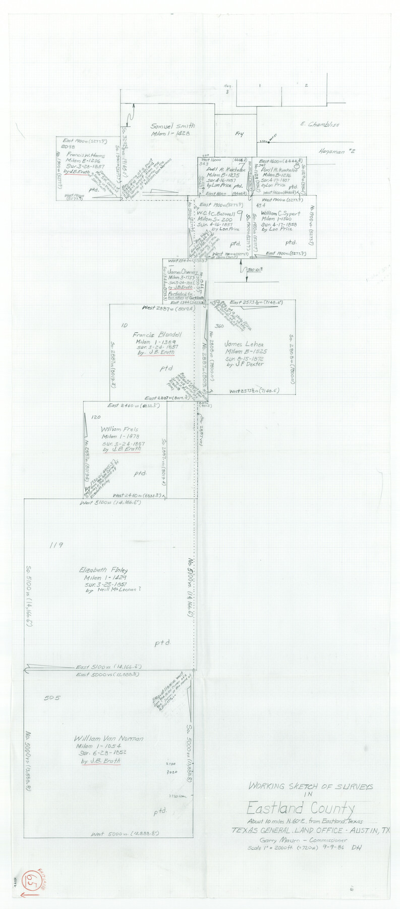
Eastland County Working Sketch 65
-
Map/Doc
88892
-
Collection
General Map Collection
-
Object Dates
9/9/1986 (Creation Date)
-
People and Organizations
Garry Mauro (GLO Commissioner)
Douglas Howard (Draftsman)
-
Counties
Eastland
-
Subjects
Surveying Working Sketch
-
Height x Width
37.4 x 16.5 inches
95.0 x 41.9 cm
-
Scale
1" = 720 varas
Part of: General Map Collection
[Sketch for Mineral Application 24072, San Jacinto River]
![65592, [Sketch for Mineral Application 24072, San Jacinto River], General Map Collection](https://historictexasmaps.com/wmedia_w700/maps/65592.tif.jpg)
Print $20.00
- Digital $50.00
[Sketch for Mineral Application 24072, San Jacinto River]
1929
Size 39.7 x 21.0 inches
Map/Doc 65592
Current Miscellaneous File 4

Print $8.00
- Digital $50.00
Current Miscellaneous File 4
1947
Size 11.5 x 9.1 inches
Map/Doc 73723
Flight Mission No. CRC-4R, Frame 65, Chambers County

Print $20.00
- Digital $50.00
Flight Mission No. CRC-4R, Frame 65, Chambers County
1956
Size 18.6 x 22.4 inches
Map/Doc 84869
Galveston County Rolled Sketch 34D

Print $71.00
- Digital $50.00
Galveston County Rolled Sketch 34D
1981
Size 9.9 x 15.1 inches
Map/Doc 45171
Map of Baylor County

Print $20.00
- Digital $50.00
Map of Baylor County
1895
Size 47.4 x 37.0 inches
Map/Doc 4882
McMullen County Sketch File 28

Print $20.00
- Digital $50.00
McMullen County Sketch File 28
1884
Size 24.8 x 28.1 inches
Map/Doc 12061
Hartley County Boundary File 5

Print $6.00
- Digital $50.00
Hartley County Boundary File 5
Size 12.7 x 8.2 inches
Map/Doc 54515
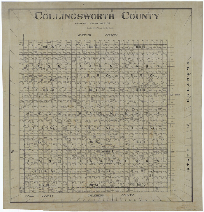
Collingsworth County
Print $20.00
- Digital $50.00
Collingsworth County
Size 42.4 x 40.6 inches
Map/Doc 66778
Louisiana and Texas Intracoastal Waterway - Sabine River-Galveston Bay Section, Steel Sheet Pile Dyke at Galveston Bay Entrance

Print $20.00
- Digital $50.00
Louisiana and Texas Intracoastal Waterway - Sabine River-Galveston Bay Section, Steel Sheet Pile Dyke at Galveston Bay Entrance
1933
Size 31.4 x 40.9 inches
Map/Doc 61818
Aransas County Boundary File 3

Print $16.00
- Digital $50.00
Aransas County Boundary File 3
Size 10.6 x 8.0 inches
Map/Doc 49782
Swisher County Sketch File 6

Print $20.00
- Digital $50.00
Swisher County Sketch File 6
Size 15.4 x 12.1 inches
Map/Doc 12404
Map of Wharton County

Print $20.00
- Digital $50.00
Map of Wharton County
1884
Size 24.8 x 28.0 inches
Map/Doc 4137
You may also like
Sutton County Rolled Sketch 57

Print $40.00
- Digital $50.00
Sutton County Rolled Sketch 57
1958
Size 40.1 x 51.1 inches
Map/Doc 10662
Houston Ship Channel, Alexander Island to Carpenter Bayou

Print $20.00
- Digital $50.00
Houston Ship Channel, Alexander Island to Carpenter Bayou
1971
Size 35.1 x 46.7 inches
Map/Doc 69907
General Highway Map, Wise County, Texas

Print $20.00
General Highway Map, Wise County, Texas
1940
Size 18.2 x 24.8 inches
Map/Doc 79284
Flight Mission No. DQO-3K, Frame 37, Galveston County

Print $20.00
- Digital $50.00
Flight Mission No. DQO-3K, Frame 37, Galveston County
1952
Size 18.7 x 22.6 inches
Map/Doc 85078
General Highway Map. Detail of Cities and Towns in Tarrant County, Texas [Fort Worth and vicinity]
![79252, General Highway Map. Detail of Cities and Towns in Tarrant County, Texas [Fort Worth and vicinity], Texas State Library and Archives](https://historictexasmaps.com/wmedia_w700/maps/79252-GC.tif.jpg)
Print $20.00
General Highway Map. Detail of Cities and Towns in Tarrant County, Texas [Fort Worth and vicinity]
1940
Size 24.9 x 18.2 inches
Map/Doc 79252
Cameron County Sketch File 11

Print $58.00
- Digital $50.00
Cameron County Sketch File 11
1991
Size 11.0 x 7.9 inches
Map/Doc 17207
Sketch of a portion of the Texas Coast showing the relative positions of different harbours with the interior Military Posts, and the roads communicating with them, also two new routes from Black Point and Lamar to San Antonio

Print $20.00
- Digital $50.00
Sketch of a portion of the Texas Coast showing the relative positions of different harbours with the interior Military Posts, and the roads communicating with them, also two new routes from Black Point and Lamar to San Antonio
1855
Size 27.2 x 18.3 inches
Map/Doc 72711
Aransas County Working Sketch 9

Print $20.00
- Digital $50.00
Aransas County Working Sketch 9
1947
Size 22.5 x 28.0 inches
Map/Doc 67176
Map of the Recognised Line M. EL. P. & P. R. R. from East Line of Bexar Land District to El Paso

Print $20.00
- Digital $50.00
Map of the Recognised Line M. EL. P. & P. R. R. from East Line of Bexar Land District to El Paso
1857
Size 7.5 x 41.8 inches
Map/Doc 2218
Martin County Working Sketch 17

Print $20.00
- Digital $50.00
Martin County Working Sketch 17
1981
Size 32.4 x 41.4 inches
Map/Doc 70835
[Surveys in the Nacogdoches District, from the Sabine River to Cowleach Fork]
![282, [Surveys in the Nacogdoches District, from the Sabine River to Cowleach Fork], General Map Collection](https://historictexasmaps.com/wmedia_w700/maps/282.tif.jpg)
Print $3.00
- Digital $50.00
[Surveys in the Nacogdoches District, from the Sabine River to Cowleach Fork]
Size 15.6 x 11.5 inches
Map/Doc 282
Flight Mission No. BRE-5P, Frame 201, Nueces County

Print $20.00
- Digital $50.00
Flight Mission No. BRE-5P, Frame 201, Nueces County
1956
Size 18.5 x 22.6 inches
Map/Doc 86841