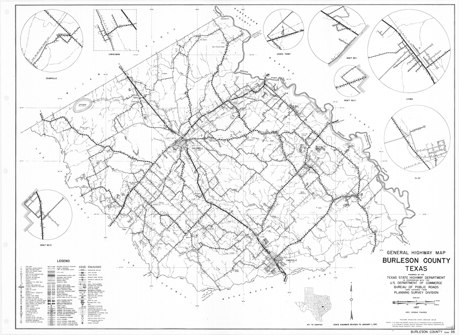
General Highway Map, Burleson County, Texas
-
Map/Doc
79391
-
Collection
Texas State Library and Archives
-
Object Dates
1961 (Creation Date)
-
People and Organizations
Texas State Highway Department (Publisher)
-
Counties
Burleson
-
Subjects
County
-
Height x Width
18.1 x 24.8 inches
46.0 x 63.0 cm
-
Comments
Prints available courtesy of the Texas State Library and Archives.
More info can be found here: TSLAC Map 05070
Part of: Texas State Library and Archives
General Highway Map, Houston County, Texas

Print $20.00
General Highway Map, Houston County, Texas
1940
Size 18.3 x 24.8 inches
Map/Doc 79133
General Highway Map, Nueces County, Texas

Print $20.00
General Highway Map, Nueces County, Texas
1961
Size 24.6 x 18.2 inches
Map/Doc 79616
General Highway Map, Randall County, Texas

Print $20.00
General Highway Map, Randall County, Texas
1940
Size 18.3 x 25.0 inches
Map/Doc 79224
General Highway Map, Collingsworth County, Texas

Print $20.00
General Highway Map, Collingsworth County, Texas
1961
Size 18.1 x 24.6 inches
Map/Doc 79415
General Highway Map, Anderson County, Texas

Print $20.00
General Highway Map, Anderson County, Texas
1961
Size 18.3 x 25.0 inches
Map/Doc 79346
General Highway Map. Detail of Cities and Towns in Gray County, Texas. [Pampa and vicinity]
![79484, General Highway Map. Detail of Cities and Towns in Gray County, Texas. [Pampa and vicinity], Texas State Library and Archives](https://historictexasmaps.com/wmedia_w700/maps/79484.tif.jpg)
Print $20.00
General Highway Map. Detail of Cities and Towns in Gray County, Texas. [Pampa and vicinity]
1961
Size 24.7 x 18.1 inches
Map/Doc 79484
General Highway Map, Parmer County, Texas

Print $20.00
General Highway Map, Parmer County, Texas
1961
Size 18.1 x 24.4 inches
Map/Doc 79626
General Highway Map, Lampasas County, Texas

Print $20.00
General Highway Map, Lampasas County, Texas
1940
Size 18.5 x 24.7 inches
Map/Doc 79169
General Highway Map, Lynn County, Texas

Print $20.00
General Highway Map, Lynn County, Texas
1961
Size 18.1 x 24.6 inches
Map/Doc 79580
General Highway Map, Bastrop County, Texas

Print $20.00
General Highway Map, Bastrop County, Texas
1940
Size 18.6 x 25.2 inches
Map/Doc 79012
General Highway Map, Floyd County, Texas

Print $20.00
General Highway Map, Floyd County, Texas
1961
Size 24.6 x 18.1 inches
Map/Doc 79467
General Highway Map, Gray County, Texas

Print $20.00
General Highway Map, Gray County, Texas
1961
Size 18.1 x 24.7 inches
Map/Doc 79483
You may also like
Haskell County Working Sketch 11

Print $20.00
- Digital $50.00
Haskell County Working Sketch 11
1976
Size 38.0 x 33.4 inches
Map/Doc 66069
General Highway Map, Detail of Cities and Towns in Delta County, Hopkins County [Cooper and vicinity]
![79440, General Highway Map, Detail of Cities and Towns in Delta County, Hopkins County [Cooper and vicinity], Texas State Library and Archives](https://historictexasmaps.com/wmedia_w700/maps/79440.tif.jpg)
Print $20.00
General Highway Map, Detail of Cities and Towns in Delta County, Hopkins County [Cooper and vicinity]
1961
Size 18.2 x 24.4 inches
Map/Doc 79440
Harris County Rolled Sketch 88

Print $20.00
- Digital $50.00
Harris County Rolled Sketch 88
1936
Size 34.6 x 22.8 inches
Map/Doc 6124
General Highway Map, Dallam County, Texas

Print $20.00
General Highway Map, Dallam County, Texas
1961
Size 24.6 x 18.3 inches
Map/Doc 79428
Robertson County Working Sketch 5

Print $20.00
- Digital $50.00
Robertson County Working Sketch 5
1980
Size 33.9 x 44.1 inches
Map/Doc 63578
[Sutton, Hale & Ector Co. School Land]
![90102, [Sutton, Hale & Ector Co. School Land], Twichell Survey Records](https://historictexasmaps.com/wmedia_w700/maps/90102-1.tif.jpg)
Print $3.00
- Digital $50.00
[Sutton, Hale & Ector Co. School Land]
Size 9.7 x 16.8 inches
Map/Doc 90102
Webb County Working Sketch 51

Print $40.00
- Digital $50.00
Webb County Working Sketch 51
1950
Size 71.7 x 40.0 inches
Map/Doc 72417
San Patricio County Rolled Sketch 55

Print $20.00
- Digital $50.00
San Patricio County Rolled Sketch 55
1999
Size 25.1 x 36.7 inches
Map/Doc 7741
Angelina County Working Sketch 12

Print $20.00
- Digital $50.00
Angelina County Working Sketch 12
1934
Size 40.8 x 37.9 inches
Map/Doc 67093
Brazos River, Millican Sheet

Print $6.00
- Digital $50.00
Brazos River, Millican Sheet
1936
Size 30.1 x 31.6 inches
Map/Doc 65278
Newton County Working Sketch 2

Print $20.00
- Digital $50.00
Newton County Working Sketch 2
1905
Size 14.5 x 19.3 inches
Map/Doc 71248
