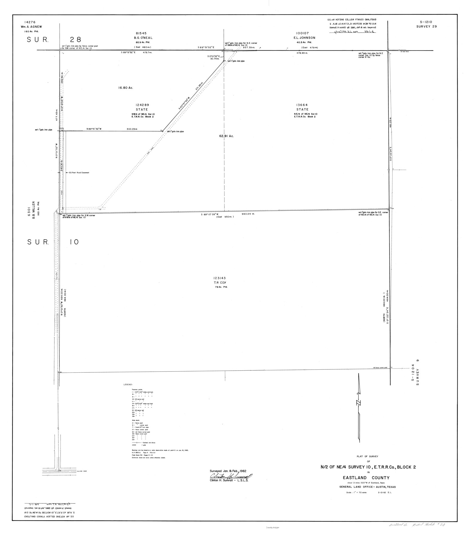
Eastland County Rolled Sketch 20
Plat of survey of N/2 of NE/4 survey 10, E. T. R.R. Co., Block 2 in Eastland County
-
Map/Doc
8826
-
Collection
General Map Collection
-
Object Dates
1982/2/12 (Creation Date)
1982/3/1 (File Date)
-
People and Organizations
Clinton H. Sumrall (Surveyor/Engineer)
-
Counties
Eastland
-
Subjects
Surveying Rolled Sketch
-
Height x Width
43.5 x 38.4 inches
110.5 x 97.5 cm
-
Scale
1" = 72 varas
Part of: General Map Collection
Coke County Working Sketch 7

Print $20.00
- Digital $50.00
Coke County Working Sketch 7
1924
Size 15.8 x 20.4 inches
Map/Doc 68044
Map of Hall County

Print $20.00
- Digital $50.00
Map of Hall County
1895
Size 25.2 x 20.2 inches
Map/Doc 3619
Flight Mission No. DAG-17K, Frame 133, Matagorda County

Print $20.00
- Digital $50.00
Flight Mission No. DAG-17K, Frame 133, Matagorda County
1952
Size 18.6 x 22.3 inches
Map/Doc 86350
Crockett County Sketch File 33

Print $30.00
- Digital $50.00
Crockett County Sketch File 33
1883
Size 13.0 x 8.2 inches
Map/Doc 19731
Lampasas County Working Sketch 8

Print $20.00
- Digital $50.00
Lampasas County Working Sketch 8
1958
Size 36.4 x 37.1 inches
Map/Doc 70285
Cameron County Rolled Sketch 27

Print $20.00
- Digital $50.00
Cameron County Rolled Sketch 27
Size 19.0 x 39.5 inches
Map/Doc 5392
Gillespie County Working Sketch 9

Print $20.00
- Digital $50.00
Gillespie County Working Sketch 9
1994
Size 27.7 x 32.3 inches
Map/Doc 63172
Gray County Sketch File 11

Print $40.00
- Digital $50.00
Gray County Sketch File 11
Size 15.0 x 13.5 inches
Map/Doc 24452
Flight Mission No. BRE-3P, Frame 36, Nueces County

Print $20.00
- Digital $50.00
Flight Mission No. BRE-3P, Frame 36, Nueces County
1956
Size 18.5 x 22.3 inches
Map/Doc 86814
Crockett County Working Sketch 15

Print $20.00
- Digital $50.00
Crockett County Working Sketch 15
1916
Size 16.2 x 20.4 inches
Map/Doc 68348
San Augustine County Sketch File 17

Print $35.00
San Augustine County Sketch File 17
1947
Size 11.5 x 8.7 inches
Map/Doc 35668
Nolan County Working Sketch 7

Print $20.00
- Digital $50.00
Nolan County Working Sketch 7
1954
Size 33.9 x 24.3 inches
Map/Doc 71298
You may also like
Flight Mission No. CGI-1N, Frame 172, Cameron County

Print $20.00
- Digital $50.00
Flight Mission No. CGI-1N, Frame 172, Cameron County
1955
Size 18.5 x 22.2 inches
Map/Doc 84507
Township 12 North Range 16 West, North Western District, Louisiana

Print $20.00
- Digital $50.00
Township 12 North Range 16 West, North Western District, Louisiana
1837
Size 19.7 x 24.8 inches
Map/Doc 65868
La Salle County Sketch File 53

Print $8.00
- Digital $50.00
La Salle County Sketch File 53
1992
Size 11.2 x 8.8 inches
Map/Doc 29624
[Map showing J. H. Gibson Block D]
![92016, [Map showing J. H. Gibson Block D], Twichell Survey Records](https://historictexasmaps.com/wmedia_w700/maps/92016-1.tif.jpg)
Print $20.00
- Digital $50.00
[Map showing J. H. Gibson Block D]
Size 17.8 x 15.1 inches
Map/Doc 92016
Sketch in Terry and Yoakum Counties

Print $20.00
- Digital $50.00
Sketch in Terry and Yoakum Counties
1945
Size 20.7 x 38.5 inches
Map/Doc 91939
Fractional Township No. 9 South Range No. 8 East of the Indian Meridian, Indian Territory

Print $20.00
- Digital $50.00
Fractional Township No. 9 South Range No. 8 East of the Indian Meridian, Indian Territory
1898
Size 19.2 x 24.4 inches
Map/Doc 75215
Dickens County Working Sketch 6

Print $20.00
- Digital $50.00
Dickens County Working Sketch 6
1932
Size 23.7 x 30.7 inches
Map/Doc 68654
Matagorda County NRC Article 33.136 Sketch 5

Print $28.00
- Digital $50.00
Matagorda County NRC Article 33.136 Sketch 5
2009
Size 24.2 x 35.0 inches
Map/Doc 95006
McLennan County Sketch File 15

Print $4.00
- Digital $50.00
McLennan County Sketch File 15
1872
Size 8.2 x 11.3 inches
Map/Doc 31274
Potter County Working Sketch 12

Print $40.00
- Digital $50.00
Potter County Working Sketch 12
1972
Size 64.4 x 42.4 inches
Map/Doc 71672
Starr County Rolled Sketch 41

Print $6.00
- Digital $50.00
Starr County Rolled Sketch 41
1971
Size 10.8 x 15.8 inches
Map/Doc 49030
[Surveys along the Colorado River]
![112, [Surveys along the Colorado River], General Map Collection](https://historictexasmaps.com/wmedia_w700/maps/112.tif.jpg)
Print $2.00
- Digital $50.00
[Surveys along the Colorado River]
1841
Size 12.2 x 8.3 inches
Map/Doc 112