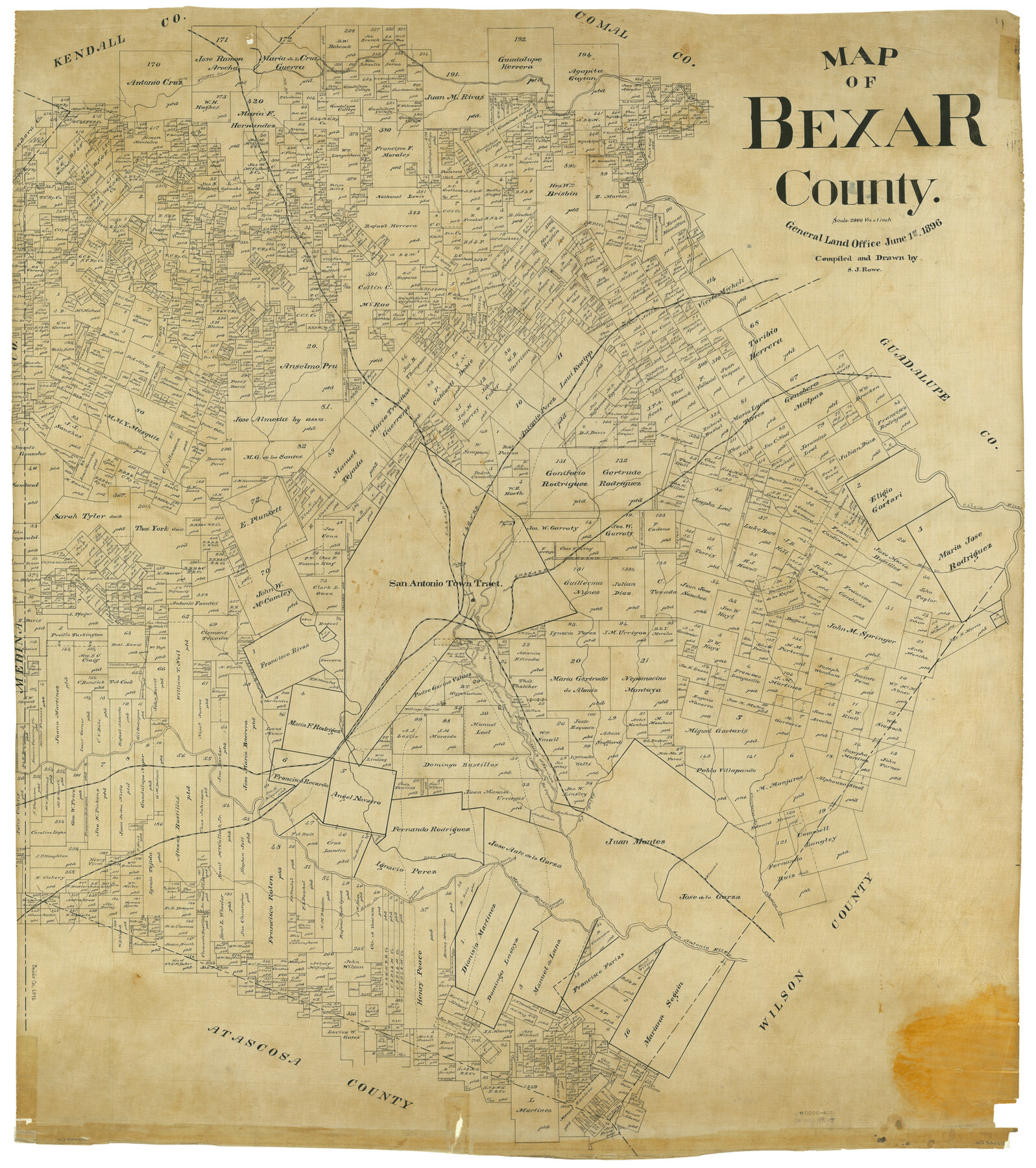
Map of Bexar County
-
Map/Doc
4885
-
Collection
General Map Collection
-
Object Dates
6/1/1896 (Creation Date)
-
People and Organizations
Texas General Land Office (Publisher)
Sidney J. Rowe (Compiler)
Sidney J. Rowe (Draftsman)
-
Counties
Bexar
-
Subjects
County
-
Height x Width
45.2 x 40.2 inches
114.8 x 102.1 cm
Part of: General Map Collection
Sutton County Rolled Sketch 52

Print $20.00
- Digital $50.00
Sutton County Rolled Sketch 52
1950
Size 20.8 x 35.2 inches
Map/Doc 7892
Deaf Smith County

Print $40.00
- Digital $50.00
Deaf Smith County
1926
Size 41.4 x 54.3 inches
Map/Doc 1816
Flight Mission No. BQY-4M, Frame 119, Harris County

Print $20.00
- Digital $50.00
Flight Mission No. BQY-4M, Frame 119, Harris County
1953
Size 18.7 x 22.4 inches
Map/Doc 85287
Jones County Working Sketch 7

Print $20.00
- Digital $50.00
Jones County Working Sketch 7
1957
Size 30.8 x 12.7 inches
Map/Doc 66645
Hays County Sketch File 5

Print $4.00
- Digital $50.00
Hays County Sketch File 5
1847
Size 12.7 x 8.3 inches
Map/Doc 26206
Polk County Sketch File 22

Print $6.00
- Digital $50.00
Polk County Sketch File 22
1887
Size 8.9 x 7.5 inches
Map/Doc 34173
Live Oak County Working Sketch 34

Print $20.00
- Digital $50.00
Live Oak County Working Sketch 34
Size 31.0 x 42.6 inches
Map/Doc 78469
Runnels County Working Sketch 1

Print $20.00
- Digital $50.00
Runnels County Working Sketch 1
Size 15.9 x 14.4 inches
Map/Doc 63597
Brewster County Rolled Sketch 6

Print $40.00
- Digital $50.00
Brewster County Rolled Sketch 6
Size 43.0 x 66.2 inches
Map/Doc 75944
Polk County Working Sketch 43

Print $20.00
- Digital $50.00
Polk County Working Sketch 43
1997
Size 23.2 x 30.5 inches
Map/Doc 71660
Starr County Sketch File 12

Print $20.00
- Digital $50.00
Starr County Sketch File 12
1886
Size 16.2 x 23.7 inches
Map/Doc 12328
Maverick County Sketch File 23a

Print $20.00
- Digital $50.00
Maverick County Sketch File 23a
Size 41.0 x 41.1 inches
Map/Doc 10537
You may also like
Pas Kaart van de Golff van Mexico

Print $20.00
- Digital $50.00
Pas Kaart van de Golff van Mexico
1695
Size 21.4 x 25.4 inches
Map/Doc 94081
Flight Mission No. DAH-9M, Frame 86, Orange County

Print $20.00
- Digital $50.00
Flight Mission No. DAH-9M, Frame 86, Orange County
1953
Size 18.4 x 22.2 inches
Map/Doc 86850

Randall County Working Sketch Graphic Index

Print $20.00
- Digital $50.00
Randall County Working Sketch Graphic Index
1958
Size 41.2 x 33.2 inches
Map/Doc 76676

Flight Mission No. DAG-21K, Frame 83, Matagorda County

Print $20.00
- Digital $50.00
Flight Mission No. DAG-21K, Frame 83, Matagorda County
1952
Size 18.7 x 22.4 inches
Map/Doc 86412

Travis County Rolled Sketch 17

Print $20.00
- Digital $50.00
Travis County Rolled Sketch 17
1940
Size 18.8 x 25.4 inches
Map/Doc 8019
Hardin County Sketch File 59

Print $6.00
- Digital $50.00
Hardin County Sketch File 59
Size 16.8 x 11.6 inches
Map/Doc 25233
Bandera County Boundary File 4a

Print $32.00
- Digital $50.00
Bandera County Boundary File 4a
Size 13.3 x 8.7 inches
Map/Doc 50276
Flight Mission No. CRC-1R, Frame 96, Chambers County

Print $20.00
- Digital $50.00
Flight Mission No. CRC-1R, Frame 96, Chambers County
1956
Size 18.6 x 22.3 inches
Map/Doc 84711
Colorado County Sketch File 32

Print $4.00
- Digital $50.00
Colorado County Sketch File 32
1847
Size 13.0 x 8.4 inches
Map/Doc 18986