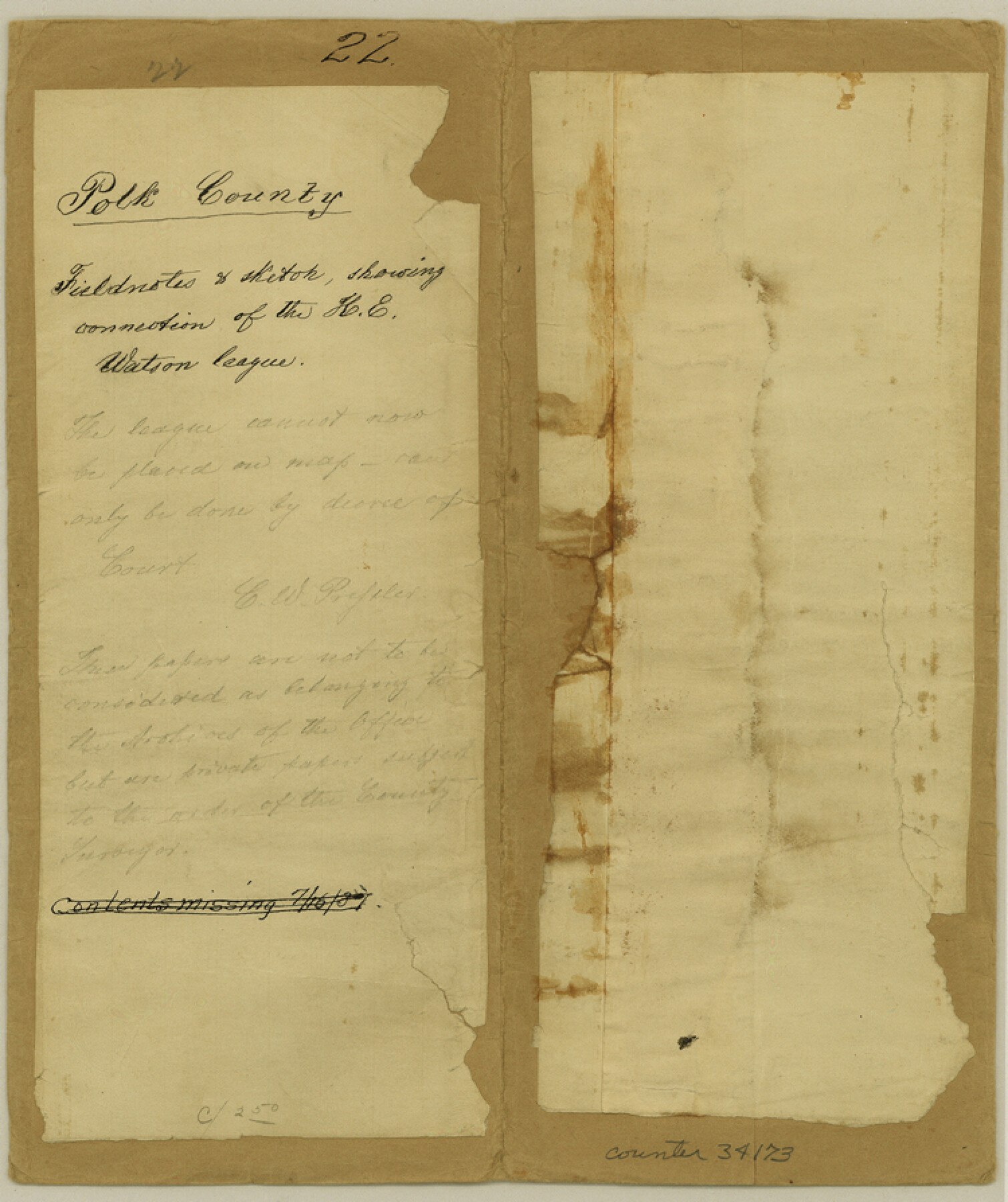
Polk County Sketch File 22
[Field notes showing connection of the H. E. Watson league]
-
Map/Doc
34173
-
Collection
General Map Collection
-
Object Dates
1/1/1887 (Creation Date)
2/4/1887 (File Date)
-
People and Organizations
W.H. Matthews (Surveyor/Engineer)
Jessie Pace (Chainman/Field Personnel)
John Chambers (Chainman/Field Personnel)
William Chambers (Chainman/Field Personnel)
-
Counties
Polk
-
Subjects
Surveying Sketch File
-
Height x Width
8.9 x 7.5 inches
22.6 x 19.1 cm
-
Medium
paper, manuscript
-
Features
Big Sandy Creek
Neches River
Prong of Double Branch
Part of: General Map Collection
General-karte der Vereinigten Staaten von Nord-Amerika nebst den grosst. Theilen von Canada & Tejas

Print $20.00
- Digital $50.00
General-karte der Vereinigten Staaten von Nord-Amerika nebst den grosst. Theilen von Canada & Tejas
1850
Size 30.3 x 38.9 inches
Map/Doc 96790
Real County Working Sketch 27

Print $20.00
- Digital $50.00
Real County Working Sketch 27
1947
Size 29.8 x 29.2 inches
Map/Doc 71919
Dallam County Rolled Sketch 7

Print $20.00
- Digital $50.00
Dallam County Rolled Sketch 7
Size 15.4 x 18.6 inches
Map/Doc 5685
Pecos County Rolled Sketch 43

Print $20.00
- Digital $50.00
Pecos County Rolled Sketch 43
1912
Size 25.4 x 34.8 inches
Map/Doc 7221
Flight Mission No. DQN-2K, Frame 160, Calhoun County

Print $20.00
- Digital $50.00
Flight Mission No. DQN-2K, Frame 160, Calhoun County
1953
Size 18.6 x 22.3 inches
Map/Doc 84322
Stephens County Sketch File 10b

Print $8.00
- Digital $50.00
Stephens County Sketch File 10b
1890
Size 8.5 x 7.8 inches
Map/Doc 37048
Rains County Working Sketch Graphic Index

Print $20.00
- Digital $50.00
Rains County Working Sketch Graphic Index
1942
Size 31.3 x 29.5 inches
Map/Doc 76675
Zavala County Sketch File 23

Print $4.00
- Digital $50.00
Zavala County Sketch File 23
1885
Size 14.4 x 8.8 inches
Map/Doc 41380
Bastrop County Sketch File 8

Print $4.00
- Digital $50.00
Bastrop County Sketch File 8
Size 8.5 x 11.5 inches
Map/Doc 14054
Ward County Rolled Sketch 13

Print $20.00
- Digital $50.00
Ward County Rolled Sketch 13
1938
Size 30.0 x 20.0 inches
Map/Doc 8156
Harris County Rolled Sketch 71

Print $20.00
- Digital $50.00
Harris County Rolled Sketch 71
1944
Size 19.3 x 26.7 inches
Map/Doc 6111
Stephens County Sketch File 6a

Print $4.00
- Digital $50.00
Stephens County Sketch File 6a
Size 12.4 x 8.4 inches
Map/Doc 37023
You may also like
Map of Kinney County

Print $20.00
- Digital $50.00
Map of Kinney County
1875
Size 25.9 x 34.2 inches
Map/Doc 3773
Dimmit County Working Sketch 8

Print $20.00
- Digital $50.00
Dimmit County Working Sketch 8
1930
Size 35.8 x 29.9 inches
Map/Doc 68669
Gray County Boundary File 10

Print $15.00
- Digital $50.00
Gray County Boundary File 10
Size 14.5 x 9.0 inches
Map/Doc 53905
Denton County Sketch File 21

Print $12.00
- Digital $50.00
Denton County Sketch File 21
1866
Size 8.7 x 8.8 inches
Map/Doc 20740
United States - Gulf Coast - From Latitude 26° 33' to the Rio Grande Texas

Print $20.00
- Digital $50.00
United States - Gulf Coast - From Latitude 26° 33' to the Rio Grande Texas
1918
Size 27.7 x 18.2 inches
Map/Doc 72850
Haskell County Rolled Sketch 15

Print $20.00
- Digital $50.00
Haskell County Rolled Sketch 15
1991
Size 12.7 x 18.4 inches
Map/Doc 6173
[Beaumont, Sour Lake and Western Ry. Right of Way and Alignment - Frisco]
![64130, [Beaumont, Sour Lake and Western Ry. Right of Way and Alignment - Frisco], General Map Collection](https://historictexasmaps.com/wmedia_w700/maps/64130.tif.jpg)
Print $20.00
- Digital $50.00
[Beaumont, Sour Lake and Western Ry. Right of Way and Alignment - Frisco]
1910
Size 20.3 x 45.9 inches
Map/Doc 64130
Panola County Sketch File 11

Print $6.00
- Digital $50.00
Panola County Sketch File 11
1872
Size 10.3 x 13.2 inches
Map/Doc 33467
Flight Mission No. CRK-5P, Frame 153, Refugio County

Print $20.00
- Digital $50.00
Flight Mission No. CRK-5P, Frame 153, Refugio County
1956
Size 18.4 x 22.3 inches
Map/Doc 86934
[Plat of Location and Right of Way from El Paso, Tex. To New Mexico Line, Rio Grande and El Paso R. R.]
![64082, [Plat of Location and Right of Way from El Paso, Tex. To New Mexico Line, Rio Grande and El Paso R. R.], General Map Collection](https://historictexasmaps.com/wmedia_w700/maps/64082.tif.jpg)
Print $40.00
- Digital $50.00
[Plat of Location and Right of Way from El Paso, Tex. To New Mexico Line, Rio Grande and El Paso R. R.]
Size 23.8 x 122.6 inches
Map/Doc 64082
Flight Mission No. BRA-8M, Frame 82, Jefferson County

Print $20.00
- Digital $50.00
Flight Mission No. BRA-8M, Frame 82, Jefferson County
1953
Size 15.8 x 15.7 inches
Map/Doc 85602
Sherman Co., U. S. Public Land

Print $20.00
- Digital $50.00
Sherman Co., U. S. Public Land
Size 15.5 x 17.4 inches
Map/Doc 91895