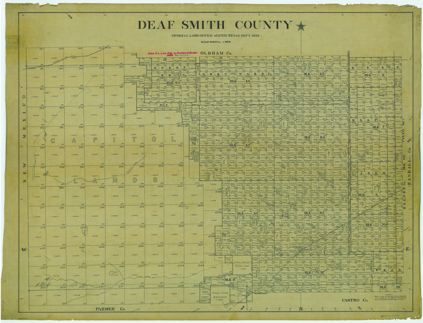
Deaf Smith County
RM-2-59
-
Map/Doc
1816
-
Collection
General Map Collection
-
Object Dates
1926 (Creation Date)
-
People and Organizations
Texas General Land Office (Publisher)
-
Counties
Deaf Smith
-
Subjects
County
-
Height x Width
41.4 x 54.3 inches
105.2 x 137.9 cm
Part of: General Map Collection
Hemphill County Rolled Sketch 15B

Print $20.00
- Digital $50.00
Hemphill County Rolled Sketch 15B
1961
Size 26.7 x 17.0 inches
Map/Doc 6196
Jefferson County Rolled Sketch 8

Print $54.00
- Digital $50.00
Jefferson County Rolled Sketch 8
1928
Size 36.0 x 46.6 inches
Map/Doc 9273
Presidio County Working Sketch 12

Print $20.00
- Digital $50.00
Presidio County Working Sketch 12
1941
Size 22.3 x 19.9 inches
Map/Doc 71687
Frio County Working Sketch 14

Print $20.00
- Digital $50.00
Frio County Working Sketch 14
1955
Size 23.7 x 22.9 inches
Map/Doc 69288
Duval County Boundary File 3f

Print $6.00
- Digital $50.00
Duval County Boundary File 3f
Size 8.1 x 5.5 inches
Map/Doc 52744
Harrison County Boundary File 2

Print $40.00
- Digital $50.00
Harrison County Boundary File 2
Size 22.6 x 7.7 inches
Map/Doc 54416
Freestone County Sketch File 28

Print $12.00
- Digital $50.00
Freestone County Sketch File 28
2002
Size 11.2 x 8.9 inches
Map/Doc 78602
Kerr County Working Sketch 37

Print $20.00
- Digital $50.00
Kerr County Working Sketch 37
1995
Size 19.0 x 24.0 inches
Map/Doc 70068
Loving County Rolled Sketch 13

Print $20.00
- Digital $50.00
Loving County Rolled Sketch 13
2006
Size 43.6 x 45.0 inches
Map/Doc 83650
Hartley County Sketch File 6

Print $20.00
- Digital $50.00
Hartley County Sketch File 6
Size 30.5 x 25.6 inches
Map/Doc 11698
Wichita County Sketch File 28

Print $22.00
- Digital $50.00
Wichita County Sketch File 28
1929
Size 12.5 x 17.0 inches
Map/Doc 40130
Jefferson County Rolled Sketch 43

Print $40.00
- Digital $50.00
Jefferson County Rolled Sketch 43
1957
Size 50.1 x 18.2 inches
Map/Doc 9303
You may also like
Edwards County Working Sketch 95

Print $20.00
- Digital $50.00
Edwards County Working Sketch 95
1968
Size 26.0 x 24.9 inches
Map/Doc 68971
![88957, Hutchinson Co[unty], Library of Congress](https://historictexasmaps.com/wmedia_w700/maps/88957.tif.jpg)
Zavala County Rolled Sketch 14

Print $20.00
- Digital $50.00
Zavala County Rolled Sketch 14
1887
Size 28.1 x 40.8 inches
Map/Doc 10175
Tarrant County

Print $20.00
- Digital $50.00
Tarrant County
1873
Size 19.1 x 17.5 inches
Map/Doc 4065

Hopkins County Sketch File 20

Print $4.00
- Digital $50.00
Hopkins County Sketch File 20
1871
Size 12.8 x 8.3 inches
Map/Doc 26725
Cooke County Sketch File 41

Print $36.00
- Digital $50.00
Cooke County Sketch File 41
1928
Size 11.3 x 8.9 inches
Map/Doc 19308
[Sketch showing surveys 9, 10, 15, 65 and 96]
![91759, [Sketch showing surveys 9, 10, 15, 65 and 96], Twichell Survey Records](https://historictexasmaps.com/wmedia_w700/maps/91759-1.tif.jpg)
Print $20.00
- Digital $50.00
[Sketch showing surveys 9, 10, 15, 65 and 96]
1919
Size 17.9 x 17.1 inches
Map/Doc 91759
General Highway Map Moore County

Print $3.00
- Digital $50.00
General Highway Map Moore County
Size 14.4 x 10.3 inches
Map/Doc 92289
Harris County Working Sketch 49

Print $20.00
- Digital $50.00
Harris County Working Sketch 49
1944
Size 28.7 x 33.9 inches
Map/Doc 65941
Hill County Boundary File 45c

Print $64.00
- Digital $50.00
Hill County Boundary File 45c
Size 14.5 x 8.8 inches
Map/Doc 54784
Flight Mission No. BRA-16M, Frame 60, Jefferson County

Print $20.00
- Digital $50.00
Flight Mission No. BRA-16M, Frame 60, Jefferson County
1953
Size 18.6 x 22.3 inches
Map/Doc 85677