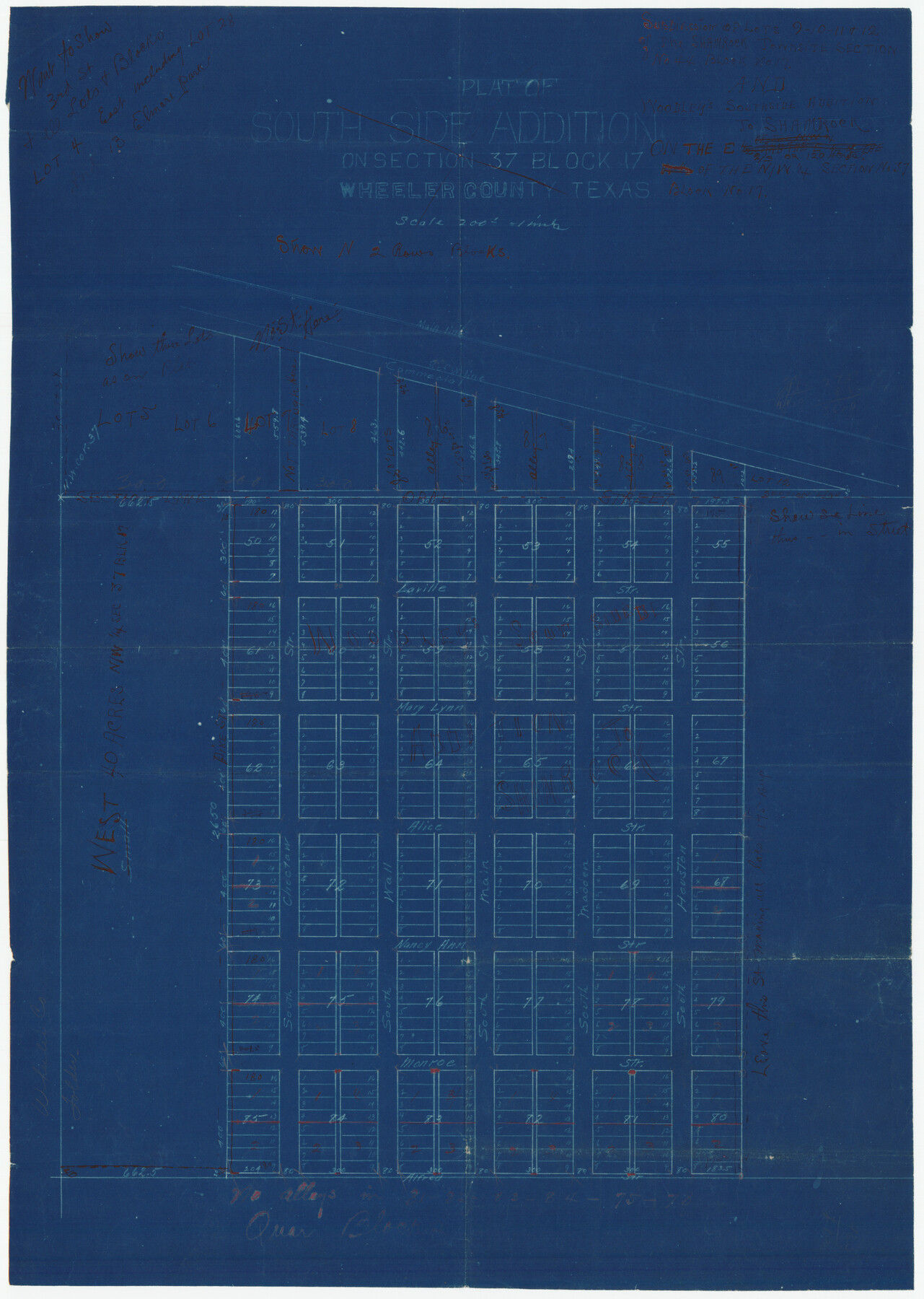
Plat of South Side Addition on Section 37 Block 17, Wheeler County, Texas
-
Map/Doc
92103
-
Collection
Twichell Survey Records
-
Counties
Wheeler
-
Height x Width
12.0 x 16.9 inches
30.5 x 42.9 cm
Part of: Twichell Survey Records
Ellis Addition to the City of Lubbock, Being a Subdivision of a Part of the SW/4 of SW/4 Sec. 4, Blk. A

Print $3.00
- Digital $50.00
Ellis Addition to the City of Lubbock, Being a Subdivision of a Part of the SW/4 of SW/4 Sec. 4, Blk. A
1952
Size 9.4 x 11.9 inches
Map/Doc 92709
[Townships 1 & 2, Blocks 53, 54 & 55]
![92952, [Townships 1 & 2, Blocks 53, 54 & 55], Twichell Survey Records](https://historictexasmaps.com/wmedia_w700/maps/92952-1.tif.jpg)
Print $20.00
- Digital $50.00
[Townships 1 & 2, Blocks 53, 54 & 55]
Size 34.3 x 20.0 inches
Map/Doc 92952
[T. & P. Block 36, Townships 1N - 5N]
![93132, [T. & P. Block 36, Townships 1N - 5N], Twichell Survey Records](https://historictexasmaps.com/wmedia_w700/maps/93132-1.tif.jpg)
Print $40.00
- Digital $50.00
[T. & P. Block 36, Townships 1N - 5N]
Size 21.3 x 87.8 inches
Map/Doc 93132
Sketch Showing Division Fence Shelton- Matador, Oldham County

Print $20.00
- Digital $50.00
Sketch Showing Division Fence Shelton- Matador, Oldham County
Size 21.8 x 24.5 inches
Map/Doc 91486
[Sketch showing Blocks B-11, O-18, P and Mc in case of Laneer vs. Bivens]
![91726, [Sketch showing Blocks B-11, O-18, P and Mc in case of Laneer vs. Bivens], Twichell Survey Records](https://historictexasmaps.com/wmedia_w700/maps/91726-1.tif.jpg)
Print $20.00
- Digital $50.00
[Sketch showing Blocks B-11, O-18, P and Mc in case of Laneer vs. Bivens]
Size 21.2 x 18.6 inches
Map/Doc 91726
Map Showing North and West Boundaries of Gray County, Texas

Print $20.00
- Digital $50.00
Map Showing North and West Boundaries of Gray County, Texas
1906
Size 42.4 x 38.9 inches
Map/Doc 89942
Preliminary Re-Plat of Lots 13-20, 45-52, 77-84, and 97-104 James Subdivision

Print $20.00
- Digital $50.00
Preliminary Re-Plat of Lots 13-20, 45-52, 77-84, and 97-104 James Subdivision
1953
Size 11.8 x 36.7 inches
Map/Doc 93222
League 206 Ochiltree County School Land

Print $20.00
- Digital $50.00
League 206 Ochiltree County School Land
Size 19.6 x 23.9 inches
Map/Doc 92479
[Blocks 3, 5 & Q]
![91275, [Blocks 3, 5 & Q], Twichell Survey Records](https://historictexasmaps.com/wmedia_w700/maps/91275-1.tif.jpg)
Print $20.00
- Digital $50.00
[Blocks 3, 5 & Q]
Size 19.4 x 9.2 inches
Map/Doc 91275
[Sketch showing Runnels County School Land survey and surrounding surveys]
![93112, [Sketch showing Runnels County School Land survey and surrounding surveys], Twichell Survey Records](https://historictexasmaps.com/wmedia_w700/maps/93112-1.tif.jpg)
Print $20.00
- Digital $50.00
[Sketch showing Runnels County School Land survey and surrounding surveys]
Size 21.4 x 14.3 inches
Map/Doc 93112
[T. & P. RR. Co. Blocks 31-36, Townships 3N, 4N and 5N and surrounding area]
![93135, [T. & P. RR. Co. Blocks 31-36, Townships 3N, 4N and 5N and surrounding area], Twichell Survey Records](https://historictexasmaps.com/wmedia_w700/maps/93135-1.tif.jpg)
Print $40.00
- Digital $50.00
[T. & P. RR. Co. Blocks 31-36, Townships 3N, 4N and 5N and surrounding area]
Size 51.3 x 51.5 inches
Map/Doc 93135
Sketch Showing Reed and Meeker Vacancy, Cochran County, Texas

Print $20.00
- Digital $50.00
Sketch Showing Reed and Meeker Vacancy, Cochran County, Texas
Size 28.9 x 20.3 inches
Map/Doc 92514
You may also like
Bosque County Sketch File 11

Print $4.00
- Digital $50.00
Bosque County Sketch File 11
1863
Size 10.2 x 8.3 inches
Map/Doc 14759
Cochran County Sketch File B

Print $2.00
- Digital $50.00
Cochran County Sketch File B
1935
Size 11.2 x 8.7 inches
Map/Doc 18544
Harris County Rolled Sketch 60

Print $20.00
- Digital $50.00
Harris County Rolled Sketch 60
1927
Size 27.4 x 21.3 inches
Map/Doc 6106
Kent County Sketch File 7

Print $20.00
- Digital $50.00
Kent County Sketch File 7
1902
Size 21.7 x 37.6 inches
Map/Doc 10514
Llano County Sketch File 4

Print $6.00
- Digital $50.00
Llano County Sketch File 4
1869
Size 12.4 x 8.0 inches
Map/Doc 30353
Subdivision of Outlots 1 and 2 in Original Townsite of Seagraves, Texas

Print $20.00
- Digital $50.00
Subdivision of Outlots 1 and 2 in Original Townsite of Seagraves, Texas
1955
Size 17.3 x 29.1 inches
Map/Doc 92688
Dimmit County Sketch File 20a

Print $2.00
- Digital $50.00
Dimmit County Sketch File 20a
Size 9.3 x 4.3 inches
Map/Doc 21103
Presidio County Working Sketch 31

Print $20.00
- Digital $50.00
Presidio County Working Sketch 31
1946
Size 25.2 x 26.3 inches
Map/Doc 71708
Hale County Sketch File 20

Print $6.00
- Digital $50.00
Hale County Sketch File 20
Size 15.7 x 10.5 inches
Map/Doc 24753
Crockett County Working Sketch 32

Print $20.00
- Digital $50.00
Crockett County Working Sketch 32
1925
Size 20.3 x 41.3 inches
Map/Doc 68365
Montgomery County Working Sketch 40

Print $20.00
- Digital $50.00
Montgomery County Working Sketch 40
1954
Size 18.1 x 23.3 inches
Map/Doc 71147
Cameron County Rolled Sketch 10

Print $20.00
- Digital $50.00
Cameron County Rolled Sketch 10
Size 38.5 x 44.5 inches
Map/Doc 8566