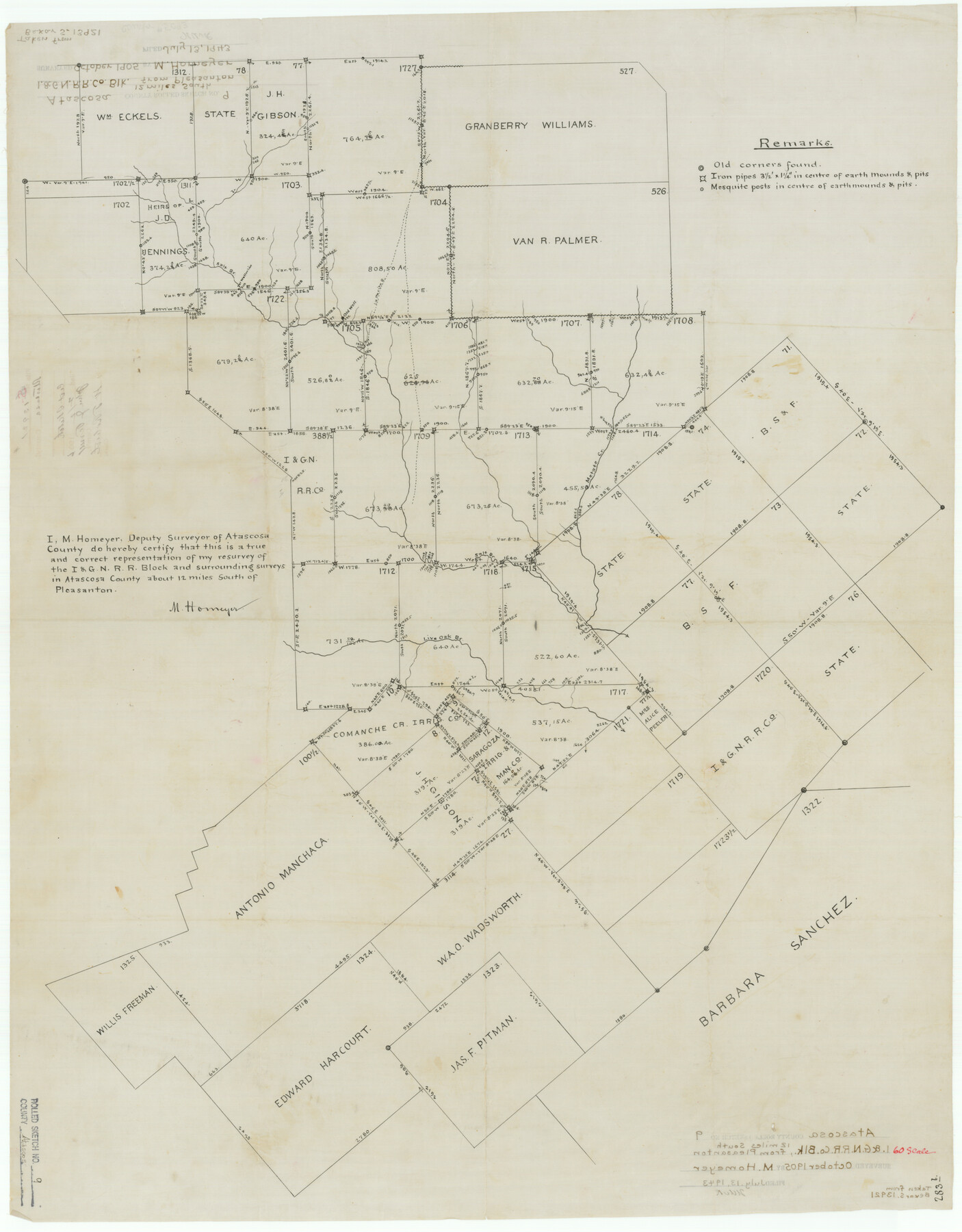
Atascosa County Rolled Sketch 9
[Resurvey of I. & G. N. R.R. Block and surrounding surveys]
- 
                          Map/Doc
5093
 - 
                            Collection
General Map Collection
 - 
                            Object Dates
1905 (Creation Date)
1943/7/13 (File Date)
 - 
                            People and Organizations
M. Homeyer (Surveyor/Engineer)
 - 
                            Counties
Atascosa
 - 
                            Subjects
Surveying Rolled Sketch
 - 
                            Height x Width
34.5 x 26.9 inches
87.6 x 68.3 cm
 - 
                            Medium
paper, manuscript
 
Part of: General Map Collection
            Flight Mission No. BQR-12K, Frame 44, Brazoria County


                                            Print $20.00                    
                                             -                         Digital $50.00                                    
                Flight Mission No. BQR-12K, Frame 44, Brazoria County
1952
Size 18.8 x 22.4 inches
                                Map/Doc 84059
            
            Hays County Boundary File 42


                                            Print $6.00                    
                                             -                         Digital $50.00                                    
                Hays County Boundary File 42
Size 9.1 x 3.7 inches
                                Map/Doc 54609
            
            Webb County Sketch File 64


                                            Print $20.00                    
                                             -                         Digital $50.00                                    
                Webb County Sketch File 64
1948
Size 23.1 x 30.6 inches
                                Map/Doc 12654
            
            1882 Map of the Texas & Pacific R-Y Reserve


                                            Print $20.00                    
                                             -                         Digital $50.00                                    
                1882 Map of the Texas & Pacific R-Y Reserve
1887
Size 44.6 x 29.8 inches
                                Map/Doc 83561
            
            Houston County Working Sketch 4


                                            Print $20.00                    
                                             -                         Digital $50.00                                    
                Houston County Working Sketch 4
1911
Size 15.5 x 21.8 inches
                                Map/Doc 66234
            
            Hardeman County Working Sketch Graphic Index


                                            Print $20.00                    
                                             -                         Digital $50.00                                    
                Hardeman County Working Sketch Graphic Index
1935
Size 42.9 x 40.5 inches
                                Map/Doc 76566
            
            Dickens County Boundary File 1


                                            Print $6.00                    
                                             -                         Digital $50.00                                    
                Dickens County Boundary File 1
Size 8.8 x 3.7 inches
                                Map/Doc 52530
            
            Clay County Boundary File 17a


                                            Print $40.00                    
                                             -                         Digital $50.00                                    
                Clay County Boundary File 17a
Size 47.0 x 22.0 inches
                                Map/Doc 51435
            
            Atascosa County Sketch File 6


                                            Print $26.00                    
                                             -                         Digital $50.00                                    
                Atascosa County Sketch File 6
Size 12.2 x 7.8 inches
                                Map/Doc 13752
            
            El Paso County


                                            Print $40.00                    
                                             -                         Digital $50.00                                    
                El Paso County
1881
Size 52.6 x 42.4 inches
                                Map/Doc 89058
            
            McMullen County Rolled Sketch 20


                                            Print $20.00                    
                                             -                         Digital $50.00                                    
                McMullen County Rolled Sketch 20
Size 27.7 x 21.7 inches
                                Map/Doc 6736
            
            Gillespie County Boundary File 6


                                            Print $2.00                    
                                             -                         Digital $50.00                                    
                Gillespie County Boundary File 6
Size 11.3 x 8.9 inches
                                Map/Doc 53770
            You may also like
            Maps of Gulf Intracoastal Waterway, Texas - Sabine River to the Rio Grande and connecting waterways including ship channels


                                            Print $20.00                    
                                             -                         Digital $50.00                                    
                Maps of Gulf Intracoastal Waterway, Texas - Sabine River to the Rio Grande and connecting waterways including ship channels
1966
Size 14.6 x 21.0 inches
                                Map/Doc 61988
            
            Hutchinson County Working Sketch 1


                                            Print $3.00                    
                                             -                         Digital $50.00                                    
                Hutchinson County Working Sketch 1
Size 9.5 x 17.0 inches
                                Map/Doc 66359
            
            Bosque County Working Sketch 24


                                            Print $20.00                    
                                             -                         Digital $50.00                                    
                Bosque County Working Sketch 24
1994
Size 34.4 x 47.4 inches
                                Map/Doc 67457
            
            W. M. Kuykendall Ranch, Matagorda County, Texas


                                            Print $20.00                    
                                             -                         Digital $50.00                                    
                W. M. Kuykendall Ranch, Matagorda County, Texas
1926
Size 24.3 x 39.6 inches
                                Map/Doc 3028
            
            Kinney County Working Sketch 28


                                            Print $20.00                    
                                             -                         Digital $50.00                                    
                Kinney County Working Sketch 28
1957
Size 33.3 x 34.4 inches
                                Map/Doc 70210
            
            Rio Grande Rectification Project, El Paso and Juarez Valley


                                            Print $20.00                    
                                             -                         Digital $50.00                                    
                Rio Grande Rectification Project, El Paso and Juarez Valley
1935
Size 10.7 x 29.4 inches
                                Map/Doc 60867
            
            The Coast & Bays of Western Texas, St. Joseph's and Mustang Islands from actual survey, the remainder from county maps, etc.


                                            Print $20.00                    
                                             -                         Digital $50.00                                    
                The Coast & Bays of Western Texas, St. Joseph's and Mustang Islands from actual survey, the remainder from county maps, etc.
1857
Size 27.9 x 18.3 inches
                                Map/Doc 72766
            
            Fort Bend County Rolled Sketch 3


                                            Print $20.00                    
                                             -                         Digital $50.00                                    
                Fort Bend County Rolled Sketch 3
1958
Size 31.4 x 31.5 inches
                                Map/Doc 5893
            
            Karnes County Sketch File 5


                                            Print $7.00                    
                                             -                         Digital $50.00                                    
                Karnes County Sketch File 5
1849
Size 8.1 x 10.0 inches
                                Map/Doc 28554
            
            Maps of Gulf Intracoastal Waterway, Texas - Sabine River to the Rio Grande and connecting waterways including ship channels


                                            Print $20.00                    
                                             -                         Digital $50.00                                    
                Maps of Gulf Intracoastal Waterway, Texas - Sabine River to the Rio Grande and connecting waterways including ship channels
1966
Size 14.5 x 22.2 inches
                                Map/Doc 61941
            
            Brazoria County Sketch File 41


                                            Print $40.00                    
                                             -                         Digital $50.00                                    
                Brazoria County Sketch File 41
1939
Size 19.5 x 26.6 inches
                                Map/Doc 10960
            
            Limestone County Working Sketch 17


                                            Print $20.00                    
                                             -                         Digital $50.00                                    
                Limestone County Working Sketch 17
1959
Size 42.2 x 33.1 inches
                                Map/Doc 70567