Aransas County Rolled Sketch 6
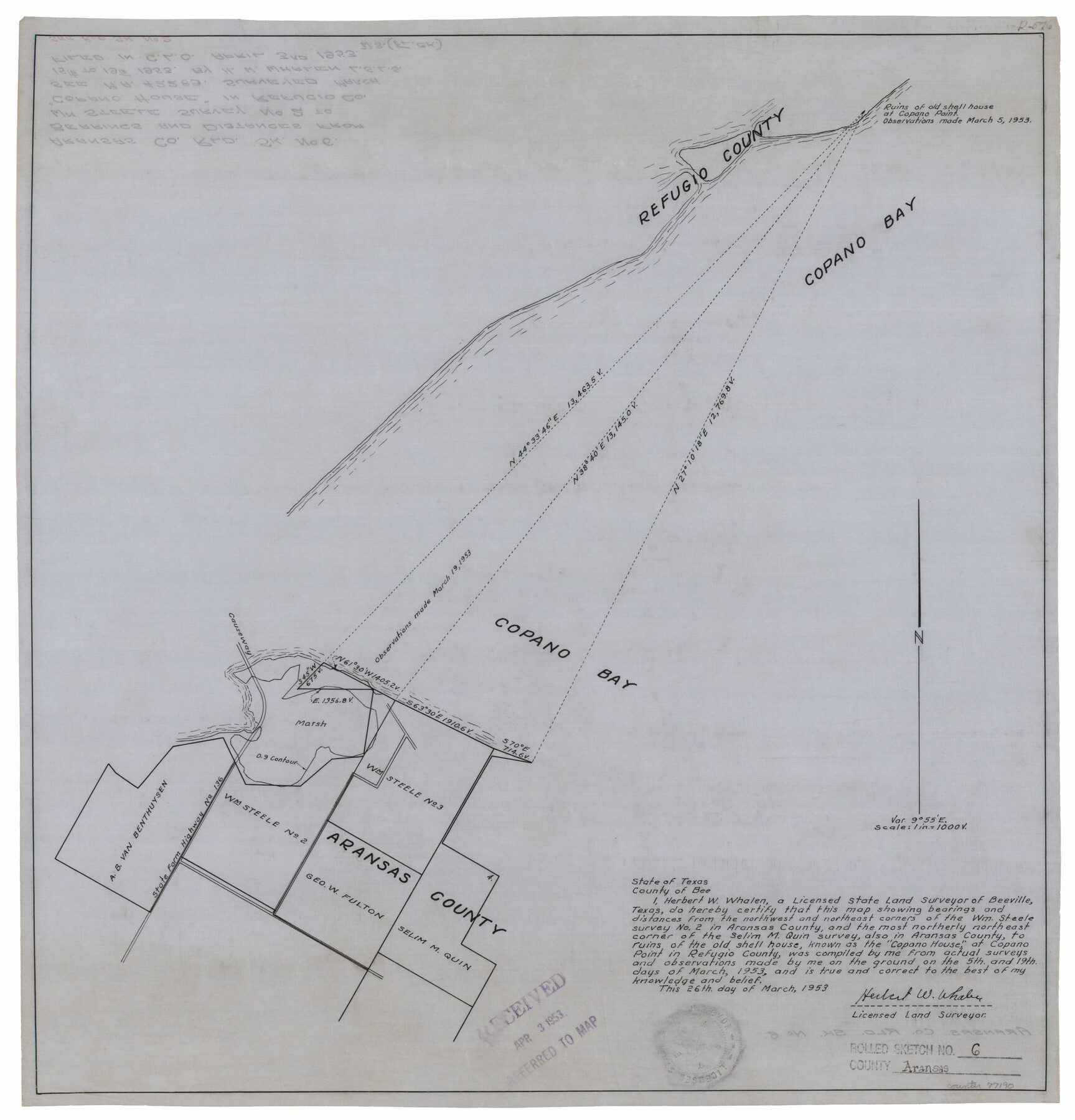
[Sketch showing bearings and distances from the northwest and northeast corners of the Wm. Steele survey no. 2 in Aransas County, and the most northerly northeast corner of the Selim M. Quin survey to "Copano House" at Copano Point in Refugio County]
-
Map/Doc
77190
-
Collection
General Map Collection
-
Object Dates
1953/3/26 (Creation Date)
1953/4/3 (File Date)
1953/3/5 (Survey Date)
1953/3/19 (Survey Date)
-
People and Organizations
Herbert W. Whalen (Surveyor/Engineer)
-
Counties
Aransas Refugio
-
Subjects
Surveying Rolled Sketch
-
Height x Width
19.6 x 18.8 inches
49.8 x 47.8 cm
-
Medium
linen, manuscript
-
Scale
1" = 1000 varas
Part of: General Map Collection
Duval County Working Sketch 14

Print $20.00
- Digital $50.00
Duval County Working Sketch 14
1938
Size 15.2 x 17.7 inches
Map/Doc 68727
Dawson County

Print $20.00
- Digital $50.00
Dawson County
1959
Size 43.5 x 35.1 inches
Map/Doc 77259
Chambers County Working Sketch 13

Print $20.00
- Digital $50.00
Chambers County Working Sketch 13
1956
Size 30.1 x 24.6 inches
Map/Doc 67996
Brewster County Working Sketch 108

Print $20.00
- Digital $50.00
Brewster County Working Sketch 108
1981
Size 37.7 x 47.6 inches
Map/Doc 67708
Central & Montgomery

Print $40.00
- Digital $50.00
Central & Montgomery
1941
Size 26.1 x 123.0 inches
Map/Doc 64523
Blanco County Working Sketch 45

Print $20.00
- Digital $50.00
Blanco County Working Sketch 45
2007
Size 23.9 x 34.0 inches
Map/Doc 88609
Map of Eastland Co.

Print $20.00
- Digital $50.00
Map of Eastland Co.
1896
Size 43.2 x 43.1 inches
Map/Doc 78410
Foard County Boundary File 4a

Print $40.00
- Digital $50.00
Foard County Boundary File 4a
Size 16.9 x 45.4 inches
Map/Doc 53522
Reagan County Sketch File 26

Print $20.00
- Digital $50.00
Reagan County Sketch File 26
1948
Size 16.9 x 28.7 inches
Map/Doc 12223
Crockett County Sketch File A1, A3, D, and DA2

Print $44.00
- Digital $50.00
Crockett County Sketch File A1, A3, D, and DA2
Size 14.3 x 8.8 inches
Map/Doc 19626
Flight Mission No. BRE-2P, Frame 8, Nueces County

Print $20.00
- Digital $50.00
Flight Mission No. BRE-2P, Frame 8, Nueces County
1956
Size 18.7 x 22.6 inches
Map/Doc 86717
Reagan County Rolled Sketch 27A

Print $40.00
- Digital $50.00
Reagan County Rolled Sketch 27A
1952
Size 63.7 x 47.2 inches
Map/Doc 9822
You may also like
Cochran County Rolled Sketch 2

Print $20.00
- Digital $50.00
Cochran County Rolled Sketch 2
1940
Size 27.7 x 33.9 inches
Map/Doc 5500
Dawson County Sketch File 26

Print $10.00
- Digital $50.00
Dawson County Sketch File 26
Size 14.7 x 9.1 inches
Map/Doc 20583
Edwards County Sketch File 26

Print $4.00
- Digital $50.00
Edwards County Sketch File 26
1910
Size 11.5 x 9.2 inches
Map/Doc 21753
Coleman County Sketch File 10

Print $20.00
- Digital $50.00
Coleman County Sketch File 10
1848
Size 28.0 x 13.2 inches
Map/Doc 11119
Armstrong County Rolled Sketch 2

Print $20.00
- Digital $50.00
Armstrong County Rolled Sketch 2
Size 23.3 x 22.3 inches
Map/Doc 5083
Hudspeth County Sketch File 13

Print $18.00
- Digital $50.00
Hudspeth County Sketch File 13
1915
Size 13.3 x 8.9 inches
Map/Doc 26929
Stonewall County Sketch File 14

Print $20.00
- Digital $50.00
Stonewall County Sketch File 14
1901
Size 21.5 x 18.3 inches
Map/Doc 12366
Baylor County Sketch File 9

Print $50.00
- Digital $50.00
Baylor County Sketch File 9
1890
Size 13.4 x 9.0 inches
Map/Doc 14139
Flight Mission No. DIX-8P, Frame 64, Aransas County

Print $20.00
- Digital $50.00
Flight Mission No. DIX-8P, Frame 64, Aransas County
1956
Size 18.7 x 22.4 inches
Map/Doc 83895
[Sketch showing E. line of Lipscomb County along Oklahoma border]
![89718, [Sketch showing E. line of Lipscomb County along Oklahoma border], Twichell Survey Records](https://historictexasmaps.com/wmedia_w700/maps/89718-1.tif.jpg)
Print $40.00
- Digital $50.00
[Sketch showing E. line of Lipscomb County along Oklahoma border]
Size 68.7 x 9.6 inches
Map/Doc 89718
Hood County Working Sketch 15

Print $20.00
- Digital $50.00
Hood County Working Sketch 15
1985
Size 30.0 x 28.2 inches
Map/Doc 66209
Colorado County Working Sketch 2

Print $20.00
- Digital $50.00
Colorado County Working Sketch 2
1904
Size 28.8 x 30.1 inches
Map/Doc 68102