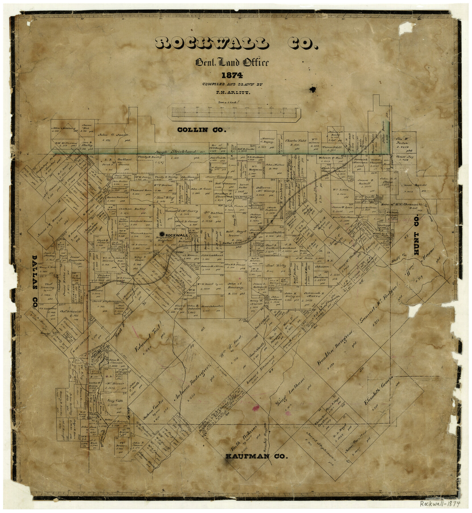
Rockwall County
-
Map/Doc
3998
-
Collection
General Map Collection
-
Object Dates
1874 (Creation Date)
-
People and Organizations
Texas General Land Office (Publisher)
F.H. Arlitt (Compiler)
F.H. Arlitt (Draftsman)
-
Counties
Rockwall
-
Subjects
County
-
Height x Width
20.3 x 18.6 inches
51.6 x 47.2 cm
-
Features
Camp Creek
Bear Pen Creek
D&G
Rockwall
Muddy Creek
Buffalo Creek
Bluff Creek
East Fork of Bois de Arc River
Brushy Bayou
Rowlet Creek
Part of: General Map Collection
Borden County Sketch File 1

Print $6.00
- Digital $50.00
Borden County Sketch File 1
Size 16.2 x 11.0 inches
Map/Doc 14701
Nacogdoches Co.

Print $40.00
- Digital $50.00
Nacogdoches Co.
1905
Size 50.7 x 42.0 inches
Map/Doc 10787
Bexar County Sketch File 8

Print $4.00
- Digital $50.00
Bexar County Sketch File 8
Size 9.4 x 7.7 inches
Map/Doc 14477
Kimble County Sketch File 9

Print $22.00
- Digital $50.00
Kimble County Sketch File 9
1871
Size 8.2 x 14.1 inches
Map/Doc 28927
Flight Mission No. BRA-16M, Frame 86, Jefferson County

Print $20.00
- Digital $50.00
Flight Mission No. BRA-16M, Frame 86, Jefferson County
1953
Size 18.5 x 22.3 inches
Map/Doc 85698
Jefferson County Rolled Sketch 31

Print $425.00
- Digital $50.00
Jefferson County Rolled Sketch 31
1955
Size 10.1 x 15.3 inches
Map/Doc 46323
Smith County Sketch File 3

Print $4.00
- Digital $50.00
Smith County Sketch File 3
1853
Size 10.5 x 8.6 inches
Map/Doc 36750
Harris County Historic Topographic 4

Print $20.00
- Digital $50.00
Harris County Historic Topographic 4
1916
Size 14.5 x 24.6 inches
Map/Doc 65814
Jefferson County Sketch File 38

Print $10.00
- Digital $50.00
Jefferson County Sketch File 38
Size 14.2 x 8.9 inches
Map/Doc 28213
Pecos County Sketch File 49c

Print $10.00
- Digital $50.00
Pecos County Sketch File 49c
Size 5.9 x 8.7 inches
Map/Doc 33768
Crane County Rolled Sketch 28

Print $40.00
- Digital $50.00
Crane County Rolled Sketch 28
2020
Size 35.7 x 51.2 inches
Map/Doc 96434
Runnels County Sketch File 17

Print $6.00
Runnels County Sketch File 17
Size 11.0 x 13.6 inches
Map/Doc 35474
You may also like
Chambers County Sketch File 20

Print $4.00
- Digital $50.00
Chambers County Sketch File 20
Size 9.2 x 7.4 inches
Map/Doc 17591
Cherokee County Sketch File 14

Print $4.00
- Digital $50.00
Cherokee County Sketch File 14
1860
Size 8.0 x 5.9 inches
Map/Doc 18147
Hays County Sketch File 11

Print $4.00
- Digital $50.00
Hays County Sketch File 11
Size 10.3 x 8.2 inches
Map/Doc 26216
Irion County Sketch File 14

Print $8.00
- Digital $50.00
Irion County Sketch File 14
1949
Size 11.2 x 8.7 inches
Map/Doc 27486

Cooke County Sketch File 32

Print $43.00
- Digital $50.00
Cooke County Sketch File 32
1873
Size 11.1 x 17.6 inches
Map/Doc 19295
Kendall County Boundary File 2b

Print $4.00
- Digital $50.00
Kendall County Boundary File 2b
Size 10.0 x 8.0 inches
Map/Doc 55754
Hutchinson County Rolled Sketch 44-14

Print $20.00
- Digital $50.00
Hutchinson County Rolled Sketch 44-14
2002
Size 24.0 x 36.0 inches
Map/Doc 77550
Real County Rolled Sketch 13

Print $20.00
- Digital $50.00
Real County Rolled Sketch 13
Size 23.0 x 34.0 inches
Map/Doc 9838
Potter County

Print $20.00
- Digital $50.00
Potter County
1960
Size 42.6 x 34.6 inches
Map/Doc 66985
Map of Madison County

Print $20.00
- Digital $50.00
Map of Madison County
1858
Size 19.8 x 31.7 inches
Map/Doc 3834
Red River County Working Sketch 26

Print $20.00
- Digital $50.00
Red River County Working Sketch 26
1961
Size 30.9 x 31.6 inches
Map/Doc 72009