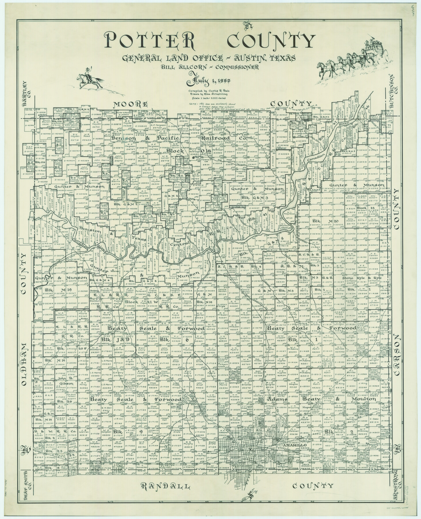
Potter County
-
Map/Doc
66985
-
Collection
General Map Collection
-
Object Dates
1960/7/1 (Creation Date)
-
People and Organizations
Texas General Land Office (Publisher)
Eltea Armstrong (Draftsman)
Curtis R. Hale (Compiler)
Bill Allcorn (GLO Commissioner)
-
Counties
Potter
-
Subjects
County
-
Height x Width
42.6 x 34.6 inches
108.2 x 87.9 cm
Part of: General Map Collection
Brewster County Sketch File 43

Print $4.00
- Digital $50.00
Brewster County Sketch File 43
Size 8.8 x 11.3 inches
Map/Doc 16309
Flight Mission No. BRA-16M, Frame 104, Jefferson County

Print $20.00
- Digital $50.00
Flight Mission No. BRA-16M, Frame 104, Jefferson County
1953
Size 18.5 x 22.3 inches
Map/Doc 85716
Matagorda County NRC Article 33.136 Sketch 23

Print $76.00
Matagorda County NRC Article 33.136 Sketch 23
2025
Map/Doc 97502
La Salle County Rolled Sketch 27

Print $20.00
- Digital $50.00
La Salle County Rolled Sketch 27
1979
Size 29.0 x 38.2 inches
Map/Doc 6588
Washington County Working Sketch 4

Print $20.00
- Digital $50.00
Washington County Working Sketch 4
1992
Size 28.2 x 25.2 inches
Map/Doc 72365
Flight Mission No. CUI-1H, Frame 140, Milam County

Print $20.00
- Digital $50.00
Flight Mission No. CUI-1H, Frame 140, Milam County
1951
Size 18.4 x 22.2 inches
Map/Doc 86606
[Sketch for Mineral Application 27669 - Trinity River, Frank R. Graves]
![65629, [Sketch for Mineral Application 27669 - Trinity River, Frank R. Graves], General Map Collection](https://historictexasmaps.com/wmedia_w700/maps/65629-1.tif.jpg)
Print $40.00
- Digital $50.00
[Sketch for Mineral Application 27669 - Trinity River, Frank R. Graves]
Size 28.0 x 102.2 inches
Map/Doc 65629
Flight Mission No. DCL-6C, Frame 8, Kenedy County

Print $20.00
- Digital $50.00
Flight Mission No. DCL-6C, Frame 8, Kenedy County
1943
Size 18.5 x 22.5 inches
Map/Doc 85868
[Sketch for Mineral Application 16696-16697, Pecos River]
![65613, [Sketch for Mineral Application 16696-16697, Pecos River], General Map Collection](https://historictexasmaps.com/wmedia_w700/maps/65613-1.tif.jpg)
Print $40.00
- Digital $50.00
[Sketch for Mineral Application 16696-16697, Pecos River]
Size 36.7 x 68.3 inches
Map/Doc 65613
Travis County Sketch File 58

Print $14.00
- Digital $50.00
Travis County Sketch File 58
1948
Size 11.4 x 8.9 inches
Map/Doc 38406
Presidio County Working Sketch 130

Print $20.00
- Digital $50.00
Presidio County Working Sketch 130
1989
Size 22.1 x 43.1 inches
Map/Doc 71808
Terrell County Working Sketch 67

Print $20.00
- Digital $50.00
Terrell County Working Sketch 67
1973
Size 32.8 x 28.2 inches
Map/Doc 69588
You may also like
Newton County Sketch File 17

Print $3.00
- Digital $50.00
Newton County Sketch File 17
1884
Size 15.5 x 10.6 inches
Map/Doc 32392
[SW Corner of Lynn County]
![92903, [SW Corner of Lynn County], Twichell Survey Records](https://historictexasmaps.com/wmedia_w700/maps/92903-1.tif.jpg)
Print $20.00
- Digital $50.00
[SW Corner of Lynn County]
1954
Size 32.2 x 31.1 inches
Map/Doc 92903
Gulf Intracoastal Waterway, Tex. - Aransas Bay to Corpus Christi Bay - Modified Route of Main Channel/Dredging

Print $20.00
- Digital $50.00
Gulf Intracoastal Waterway, Tex. - Aransas Bay to Corpus Christi Bay - Modified Route of Main Channel/Dredging
1958
Size 31.5 x 43.0 inches
Map/Doc 61898

Oldham County Working Sketch 5

Print $40.00
- Digital $50.00
Oldham County Working Sketch 5
1951
Size 43.0 x 59.3 inches
Map/Doc 71327
Dimmit County Boundary File 2

Print $4.00
- Digital $50.00
Dimmit County Boundary File 2
Size 10.0 x 7.9 inches
Map/Doc 52564
Montgomery County Sketch File 18

Print $20.00
- Digital $50.00
Montgomery County Sketch File 18
1899
Size 22.1 x 19.6 inches
Map/Doc 42122
University Land Field Notes for Blocks 1, 2, 3, 4, 5, 8, 9, and 10 in Andrews County, Block 6 in Andrews, Dawson, Gaines, and Martin Counties, and Block 7 in Andrews and Martin Counties

University Land Field Notes for Blocks 1, 2, 3, 4, 5, 8, 9, and 10 in Andrews County, Block 6 in Andrews, Dawson, Gaines, and Martin Counties, and Block 7 in Andrews and Martin Counties
Map/Doc 81710
Lipscomb County Rolled Sketch 1

Print $40.00
- Digital $50.00
Lipscomb County Rolled Sketch 1
Size 65.0 x 15.8 inches
Map/Doc 9449
[Block K, Public School Land]
![92907, [Block K, Public School Land], Twichell Survey Records](https://historictexasmaps.com/wmedia_w700/maps/92907-1.tif.jpg)
Print $20.00
- Digital $50.00
[Block K, Public School Land]
1902
Size 17.9 x 32.8 inches
Map/Doc 92907
Galveston Harbor and Channel, Texas - Rehabilitation of Galveston Groins - Location Plan of Rehabilitation

Print $4.00
- Digital $50.00
Galveston Harbor and Channel, Texas - Rehabilitation of Galveston Groins - Location Plan of Rehabilitation
1968
Size 19.7 x 21.5 inches
Map/Doc 73627
Jeff Davis County Working Sketch Graphic Index - central part

Print $40.00
- Digital $50.00
Jeff Davis County Working Sketch Graphic Index - central part
1982
Size 55.7 x 42.6 inches
Map/Doc 76593