Harris County Historic Topographic 4
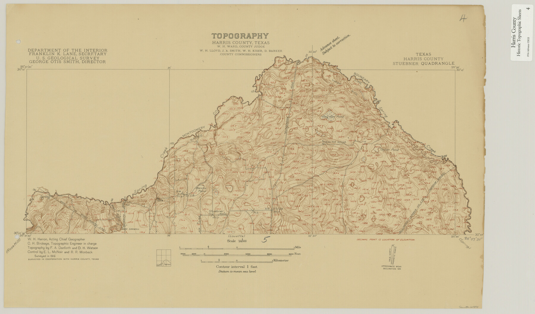
Stuebner Quadrangle
-
Map/Doc
65814
-
Collection
General Map Collection
-
Object Dates
1916 (Creation Date)
-
People and Organizations
U. S. Geological Survey (Publisher)
-
Counties
Harris
-
Subjects
Topographic
-
Height x Width
14.5 x 24.6 inches
36.8 x 62.5 cm
Part of: General Map Collection
Donley County

Print $20.00
- Digital $50.00
Donley County
1944
Size 46.0 x 40.5 inches
Map/Doc 73134
Burnet County Rolled Sketch 4

Print $20.00
- Digital $50.00
Burnet County Rolled Sketch 4
1949
Size 31.9 x 17.5 inches
Map/Doc 5356
Dickens County Sketch File 3

Print $6.00
- Digital $50.00
Dickens County Sketch File 3
1880
Size 6.9 x 6.4 inches
Map/Doc 20959
Loving County Working Sketch 2

Print $20.00
- Digital $50.00
Loving County Working Sketch 2
1937
Size 33.9 x 42.5 inches
Map/Doc 70634
Sterling County Sketch File 14

Print $20.00
- Digital $50.00
Sterling County Sketch File 14
Size 18.9 x 16.4 inches
Map/Doc 12360
Harris County Boundary File 39 (1)

Print $45.00
- Digital $50.00
Harris County Boundary File 39 (1)
Size 4.5 x 16.3 inches
Map/Doc 54326
Reagan County Working Sketch 38

Print $40.00
- Digital $50.00
Reagan County Working Sketch 38
1969
Size 60.8 x 30.5 inches
Map/Doc 71880
Flight Mission No. CRK-3P, Frame 70, Refugio County

Print $20.00
- Digital $50.00
Flight Mission No. CRK-3P, Frame 70, Refugio County
1956
Size 18.6 x 22.5 inches
Map/Doc 86912
Washington County

Print $20.00
- Digital $50.00
Washington County
1976
Size 31.7 x 46.5 inches
Map/Doc 73317
Dawson County Sketch File 19

Print $20.00
- Digital $50.00
Dawson County Sketch File 19
1951
Size 18.5 x 24.7 inches
Map/Doc 11295
Somervell County Sketch File 6

Print $6.00
- Digital $50.00
Somervell County Sketch File 6
1939
Size 13.6 x 8.6 inches
Map/Doc 36847
Castro County Sketch File 7

Print $10.00
- Digital $50.00
Castro County Sketch File 7
1905
Size 10.9 x 8.0 inches
Map/Doc 17495
You may also like
Marion County Working Sketch 5

Print $20.00
- Digital $50.00
Marion County Working Sketch 5
1910
Size 24.5 x 15.2 inches
Map/Doc 70780
Armstrong County Rolled Sketch OS

Print $20.00
- Digital $50.00
Armstrong County Rolled Sketch OS
1902
Size 17.5 x 32.4 inches
Map/Doc 5086
Frio County Working Sketch 5

Print $20.00
- Digital $50.00
Frio County Working Sketch 5
1936
Size 33.9 x 23.0 inches
Map/Doc 69279
Brewster County Rolled Sketch 60

Print $20.00
- Digital $50.00
Brewster County Rolled Sketch 60
Size 24.8 x 36.5 inches
Map/Doc 61783
Crockett County Sketch File 92

Print $21.00
- Digital $50.00
Crockett County Sketch File 92
1925
Size 11.4 x 8.8 inches
Map/Doc 19937
Nueces County

Print $20.00
- Digital $50.00
Nueces County
1913
Size 26.4 x 34.1 inches
Map/Doc 66957
Flight Mission No. DCL-7C, Frame 44, Kenedy County

Print $20.00
- Digital $50.00
Flight Mission No. DCL-7C, Frame 44, Kenedy County
1943
Size 15.4 x 15.2 inches
Map/Doc 86032
Bailey County

Print $40.00
- Digital $50.00
Bailey County
1956
Size 49.4 x 31.4 inches
Map/Doc 95423
Live Oak County Working Sketch 18

Print $20.00
- Digital $50.00
Live Oak County Working Sketch 18
1961
Size 30.2 x 29.6 inches
Map/Doc 70603
English Field Notes of the Spanish Archives - Book J. Strode

English Field Notes of the Spanish Archives - Book J. Strode
1835
Map/Doc 96549
[Part of North line of County, North of Block G]
![90805, [Part of North line of County, North of Block G], Twichell Survey Records](https://historictexasmaps.com/wmedia_w700/maps/90805-1.tif.jpg)
Print $20.00
- Digital $50.00
[Part of North line of County, North of Block G]
Size 17.6 x 12.1 inches
Map/Doc 90805
Cass County Sketch File 12

Print $4.00
- Digital $50.00
Cass County Sketch File 12
1851
Size 8.2 x 12.3 inches
Map/Doc 17414