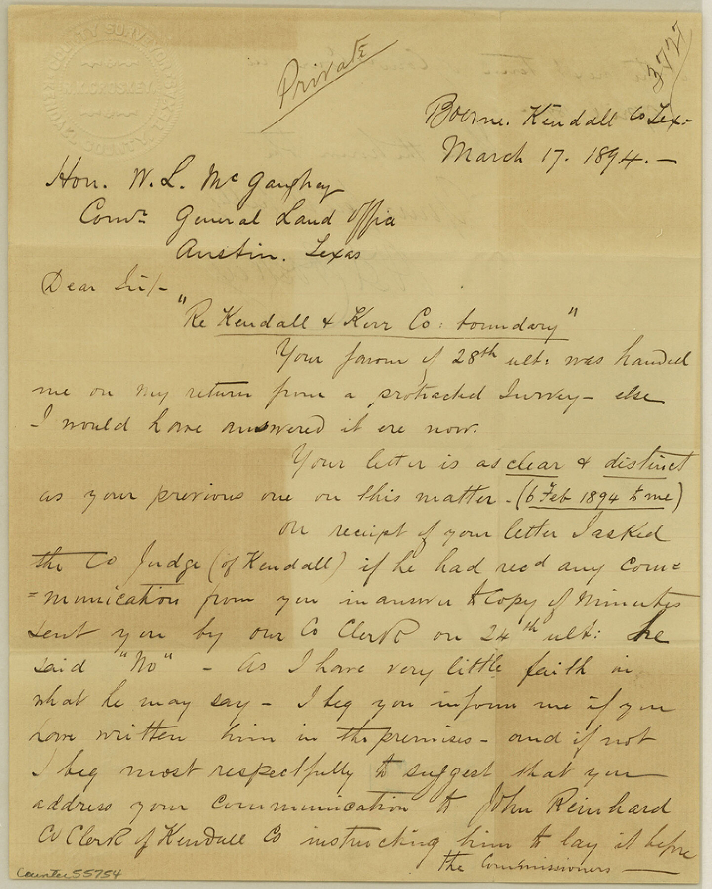
Kendall County Boundary File 2b
Re Kendall & Kerr Co. boundary
-
Map/Doc
55754
-
Collection
General Map Collection
-
Counties
Kendall
-
Subjects
County Boundaries
-
Height x Width
10.0 x 8.0 inches
25.4 x 20.3 cm
Part of: General Map Collection
Three Sitios of Land Granted to Vicente Micheli April 28th 1806

Print $2.00
- Digital $50.00
Three Sitios of Land Granted to Vicente Micheli April 28th 1806
1835
Size 11.8 x 8.1 inches
Map/Doc 170
Archer County Sketch File 20

Print $6.00
- Digital $50.00
Archer County Sketch File 20
1936
Size 11.0 x 8.7 inches
Map/Doc 13655
Uvalde County Sketch File 18

Print $6.00
- Digital $50.00
Uvalde County Sketch File 18
1883
Size 10.9 x 8.2 inches
Map/Doc 38997
Sterling County Rolled Sketch 16

Print $40.00
- Digital $50.00
Sterling County Rolled Sketch 16
1951
Size 73.6 x 43.0 inches
Map/Doc 9948
Current Miscellaneous File 40

Print $10.00
- Digital $50.00
Current Miscellaneous File 40
Size 14.2 x 8.7 inches
Map/Doc 73972
Midland County Boundary File 2

Print $24.00
- Digital $50.00
Midland County Boundary File 2
Size 8.9 x 5.5 inches
Map/Doc 57162
Grayson County Sketch File 3a

Print $20.00
- Digital $50.00
Grayson County Sketch File 3a
1855
Size 19.6 x 25.5 inches
Map/Doc 11580
Leon County Sketch File 23

Print $12.00
- Digital $50.00
Leon County Sketch File 23
1932
Size 11.1 x 8.7 inches
Map/Doc 29775
[Surveys in Chambers County]
![249, [Surveys in Chambers County], General Map Collection](https://historictexasmaps.com/wmedia_w700/maps/249.tif.jpg)
Print $2.00
- Digital $50.00
[Surveys in Chambers County]
1847
Size 7.8 x 5.0 inches
Map/Doc 249
Hudspeth County Sketch File 51

Print $4.00
- Digital $50.00
Hudspeth County Sketch File 51
1962
Size 14.4 x 9.1 inches
Map/Doc 27074
Wise County Rolled Sketch 6

Print $20.00
- Digital $50.00
Wise County Rolled Sketch 6
2000
Size 32.0 x 43.1 inches
Map/Doc 8280
Navarro County Working Sketch 1c

Print $2.00
- Digital $50.00
Navarro County Working Sketch 1c
Size 7.1 x 10.6 inches
Map/Doc 71231
You may also like
Bee County Working Sketch 34

Print $20.00
- Digital $50.00
Bee County Working Sketch 34
1988
Size 46.3 x 43.6 inches
Map/Doc 67285
Sterling County Working Sketch 8

Print $20.00
- Digital $50.00
Sterling County Working Sketch 8
1972
Size 40.7 x 35.9 inches
Map/Doc 63990
[I. & G. N. Block 1, Secs. 65-75]
![90307, [I. & G. N. Block 1, Secs. 65-75], Twichell Survey Records](https://historictexasmaps.com/wmedia_w700/maps/90307-1.tif.jpg)
Print $20.00
- Digital $50.00
[I. & G. N. Block 1, Secs. 65-75]
1928
Size 22.0 x 18.0 inches
Map/Doc 90307
Moore County Sketch File 13

Print $24.00
- Digital $50.00
Moore County Sketch File 13
1919
Size 7.0 x 8.7 inches
Map/Doc 31949

Flight Mission No. BRA-7M, Frame 143, Jefferson County

Print $20.00
- Digital $50.00
Flight Mission No. BRA-7M, Frame 143, Jefferson County
1953
Size 18.7 x 22.5 inches
Map/Doc 85537
Harris County Rolled Sketch WB

Print $20.00
- Digital $50.00
Harris County Rolled Sketch WB
1916
Size 15.5 x 21.1 inches
Map/Doc 6147
Cottle County Rolled Sketch 14

Print $741.00
- Digital $50.00
Cottle County Rolled Sketch 14
1882
Size 10.8 x 16.0 inches
Map/Doc 42369
Red River County Working Sketch 15

Print $20.00
- Digital $50.00
Red River County Working Sketch 15
1953
Size 25.8 x 23.4 inches
Map/Doc 71998
Jeff Davis County Sketch File 39

Print $10.00
- Digital $50.00
Jeff Davis County Sketch File 39
Size 14.2 x 8.7 inches
Map/Doc 28057
Sulphur River, Bassett Sheet

Print $6.00
- Digital $50.00
Sulphur River, Bassett Sheet
1939
Size 23.9 x 31.2 inches
Map/Doc 65176
Jasper County Sketch File 12b

Print $4.00
- Digital $50.00
Jasper County Sketch File 12b
Size 12.7 x 7.6 inches
Map/Doc 27802