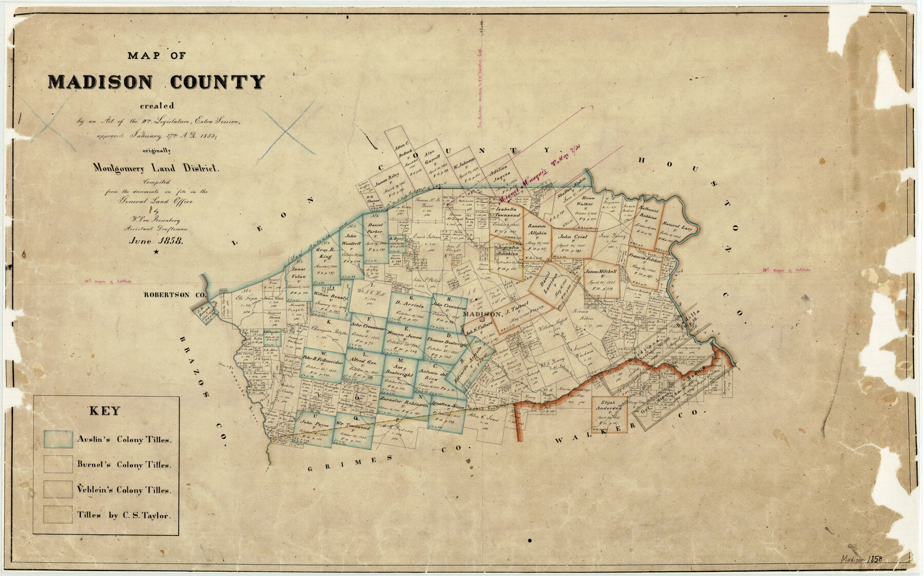
Map of Madison County
-
Map/Doc
3834
-
Collection
General Map Collection
-
Object Dates
6/1858 (Creation Date)
-
People and Organizations
Texas General Land Office (Publisher)
W. von Rosenberg (Compiler)
-
Counties
Madison
-
Subjects
County
-
Height x Width
19.8 x 31.7 inches
50.3 x 80.5 cm
-
Comments
Originally Montgomery Land District.
-
Features
Caney Creek
South Bidais Creek
Prewitt's Creek
Navasoto [sic] River
Shephard's Creek
Collard's Creek
Bidais Creek
Pool's Creek
Madison
Nacogdoches Road
San Antonio and Nacogdoches Road
San Antonio Road
Brushy Creek
Larrison Creek
York's Creek
Trinity River
Robbin's Ferry
Part of: General Map Collection
Corpus Christi Bay

Print $20.00
- Digital $50.00
Corpus Christi Bay
1976
Size 36.2 x 47.8 inches
Map/Doc 73476
Burnet County Boundary File 4

Print $30.00
- Digital $50.00
Burnet County Boundary File 4
Size 8.8 x 8.1 inches
Map/Doc 50872
Hays County State Real Property Sketch 1

Print $20.00
- Digital $50.00
Hays County State Real Property Sketch 1
2005
Size 31.1 x 42.2 inches
Map/Doc 83423
Die Vereinigten Staaten v. Nord-America

Print $20.00
- Digital $50.00
Die Vereinigten Staaten v. Nord-America
1846
Size 21.0 x 27.9 inches
Map/Doc 94513
Brewster County Rolled Sketch 19

Print $20.00
- Digital $50.00
Brewster County Rolled Sketch 19
Size 25.4 x 25.1 inches
Map/Doc 5198
Map of the Territory of the United States from the Mississippi to the Pacific Ocean ordered by the Hon. Jeff'n Davis, Secretary of War to accompany the reports of the explorations for a railroad route

Print $40.00
- Digital $50.00
Map of the Territory of the United States from the Mississippi to the Pacific Ocean ordered by the Hon. Jeff'n Davis, Secretary of War to accompany the reports of the explorations for a railroad route
Size 48.6 x 50.7 inches
Map/Doc 94276
Sketch of 103rd Meridian, W. L. Showing Conflict of Capitol Leagues

Print $40.00
- Digital $50.00
Sketch of 103rd Meridian, W. L. Showing Conflict of Capitol Leagues
Size 25.8 x 122.0 inches
Map/Doc 65504
Burnet County Working Sketch 22

Print $40.00
- Digital $50.00
Burnet County Working Sketch 22
1986
Size 40.5 x 50.9 inches
Map/Doc 67865
Sketch Richland Creek, Robertson Co.

Print $2.00
- Digital $50.00
Sketch Richland Creek, Robertson Co.
Size 10.4 x 7.9 inches
Map/Doc 266
Collin County Working Sketch 8

Print $20.00
- Digital $50.00
Collin County Working Sketch 8
2010
Size 27.4 x 18.9 inches
Map/Doc 89262
Caldwell County

Print $20.00
- Digital $50.00
Caldwell County
1935
Size 37.8 x 42.0 inches
Map/Doc 73095
San Patricio County Sketch File 41

Print $4.00
- Digital $50.00
San Patricio County Sketch File 41
1842
Size 5.2 x 8.0 inches
Map/Doc 36238
You may also like
Tom Green County Sketch File 69

Print $40.00
- Digital $50.00
Tom Green County Sketch File 69
1945
Size 16.5 x 12.4 inches
Map/Doc 38239
Railroad Track Map, H&TCRRCo., Falls County, Texas

Print $4.00
- Digital $50.00
Railroad Track Map, H&TCRRCo., Falls County, Texas
1918
Size 11.7 x 18.5 inches
Map/Doc 62843
Van Zandt County

Print $20.00
- Digital $50.00
Van Zandt County
1972
Size 47.6 x 42.0 inches
Map/Doc 95662
Van Zandt County Sketch File 33

Print $8.00
- Digital $50.00
Van Zandt County Sketch File 33
1860
Size 12.4 x 7.8 inches
Map/Doc 39469
Kleberg County Aerial Photograph Index Sheet 4

Print $20.00
- Digital $50.00
Kleberg County Aerial Photograph Index Sheet 4
1956
Size 19.3 x 23.3 inches
Map/Doc 83721
Milam County Boundary File 2

Print $30.00
- Digital $50.00
Milam County Boundary File 2
Size 12.7 x 8.2 inches
Map/Doc 57202
Duval County Sketch File 17

Print $20.00
- Digital $50.00
Duval County Sketch File 17
1876
Size 19.0 x 17.8 inches
Map/Doc 11383

[Map of the City of South Padre Island]
![3212, [Map of the City of South Padre Island], General Map Collection](https://historictexasmaps.com/wmedia_w700/maps/3212-1.tif.jpg)
Print $20.00
- Digital $50.00
[Map of the City of South Padre Island]
1993
Size 12.5 x 36.5 inches
Map/Doc 3212
Jefferson County Working Sketch 7

Print $20.00
- Digital $50.00
Jefferson County Working Sketch 7
1931
Size 18.0 x 18.6 inches
Map/Doc 66550
Dickens County Rolled Sketch P3

Print $20.00
- Digital $50.00
Dickens County Rolled Sketch P3
1917
Size 41.4 x 36.1 inches
Map/Doc 8785
Liberty County Working Sketch 91b

Print $40.00
- Digital $50.00
Liberty County Working Sketch 91b
1919
Size 48.7 x 42.1 inches
Map/Doc 65458