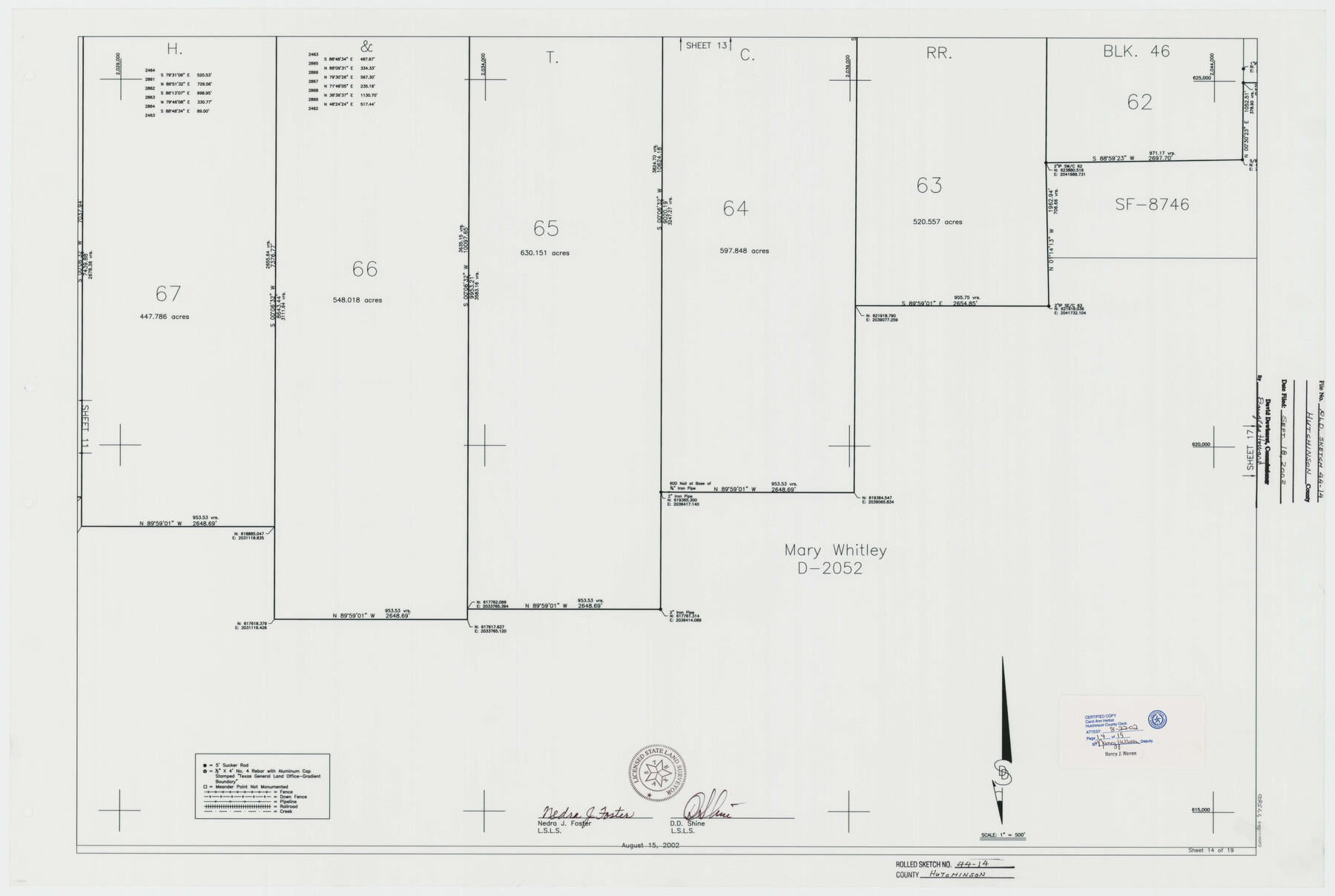
Hutchinson County Rolled Sketch 44-14
Canadian River Survey, Hutchinson County, Texas [Sheet 14 of 19]
-
Map/Doc
77550
-
Collection
General Map Collection
-
Object Dates
2002/8/15 (Creation Date)
2002/9/18 (File Date)
-
People and Organizations
Nedra J. Foster (Surveyor/Engineer)
D.D. Shine (Surveyor/Engineer)
-
Counties
Hutchinson
-
Subjects
Surveying Rolled Sketch
-
Height x Width
24.0 x 36.0 inches
61.0 x 91.4 cm
-
Medium
mylar, print
-
Scale
1" = 500 feet
Part of: General Map Collection
Colorado County Sketch File 33

Print $44.00
- Digital $50.00
Colorado County Sketch File 33
1847
Size 13.2 x 16.2 inches
Map/Doc 18988
Hudspeth County Sketch File 30

Print $8.00
- Digital $50.00
Hudspeth County Sketch File 30
1950
Size 11.3 x 8.8 inches
Map/Doc 26986
Edwards County Sketch File 44

Print $4.00
- Digital $50.00
Edwards County Sketch File 44
1948
Size 11.4 x 8.9 inches
Map/Doc 21777
Nueces County

Print $20.00
- Digital $50.00
Nueces County
1913
Size 26.9 x 35.9 inches
Map/Doc 95602
Flight Mission No. CGI-1N, Frame 134, Cameron County

Print $20.00
- Digital $50.00
Flight Mission No. CGI-1N, Frame 134, Cameron County
1955
Size 18.5 x 22.1 inches
Map/Doc 84490
Hardin County Rolled Sketch 17

Print $20.00
- Digital $50.00
Hardin County Rolled Sketch 17
1951
Size 38.3 x 32.4 inches
Map/Doc 6087
San Augustine County Sketch File 9

Print $4.00
San Augustine County Sketch File 9
1860
Size 12.6 x 7.6 inches
Map/Doc 35650
Nueces County NRC Article 33.136 Location Key Sheet

Print $20.00
- Digital $50.00
Nueces County NRC Article 33.136 Location Key Sheet
1975
Size 27.0 x 23.0 inches
Map/Doc 88586
Stephens County Working Sketch 23

Print $20.00
- Digital $50.00
Stephens County Working Sketch 23
1975
Size 31.0 x 38.8 inches
Map/Doc 63966
Crane County Working Sketch 1

Print $20.00
- Digital $50.00
Crane County Working Sketch 1
1906
Size 30.5 x 27.0 inches
Map/Doc 68278
Austin County Sketch File 14

Print $40.00
- Digital $50.00
Austin County Sketch File 14
Size 18.8 x 8.8 inches
Map/Doc 13880
Val Verde County Sketch File 56

Print $2.00
- Digital $50.00
Val Verde County Sketch File 56
2006
Size 8.5 x 11.0 inches
Map/Doc 89016
You may also like
Gaines County Rolled Sketch 33

Print $20.00
- Digital $50.00
Gaines County Rolled Sketch 33
1995
Size 17.4 x 18.2 inches
Map/Doc 76413
[County Line between DeWitt and Lavaca Counties]
![65355, [County Line between DeWitt and Lavaca Counties], General Map Collection](https://historictexasmaps.com/wmedia_w700/pdf_converted_jpg/qi_pdf_thumbnail_19782.jpg)
Print $226.00
- Digital $50.00
[County Line between DeWitt and Lavaca Counties]
1906
Size 17.4 x 34.4 inches
Map/Doc 65355
Houston County Working Sketch 36

Print $40.00
- Digital $50.00
Houston County Working Sketch 36
1987
Size 61.2 x 43.6 inches
Map/Doc 78231
Edwards County Sketch File 18

Print $6.00
- Digital $50.00
Edwards County Sketch File 18
Size 16.3 x 10.6 inches
Map/Doc 21738
Map of Shackelford County, Texas

Print $20.00
- Digital $50.00
Map of Shackelford County, Texas
1879
Size 28.7 x 23.4 inches
Map/Doc 616
Ellis County Sketch File 14

Print $40.00
- Digital $50.00
Ellis County Sketch File 14
1861
Size 12.9 x 16.1 inches
Map/Doc 21854
General Highway Map, Nolan County, Texas

Print $20.00
General Highway Map, Nolan County, Texas
1940
Size 18.4 x 24.7 inches
Map/Doc 79208
Mitchell County Working Sketch 4

Print $20.00
- Digital $50.00
Mitchell County Working Sketch 4
1926
Size 28.5 x 31.5 inches
Map/Doc 71061
Winkler County

Print $20.00
- Digital $50.00
Winkler County
1901
Size 36.2 x 45.8 inches
Map/Doc 93038
[Edwards Co.]
![66811, [Edwards Co.], General Map Collection](https://historictexasmaps.com/wmedia_w700/maps/66811.tif.jpg)
Print $20.00
- Digital $50.00
[Edwards Co.]
1910
Size 38.8 x 36.2 inches
Map/Doc 66811
[Eastern Texas RR. Co. Block 1]
![91896, [Eastern Texas RR. Co. Block 1], Twichell Survey Records](https://historictexasmaps.com/wmedia_w700/maps/91896-1.tif.jpg)
Print $20.00
- Digital $50.00
[Eastern Texas RR. Co. Block 1]
Size 17.9 x 15.3 inches
Map/Doc 91896
Fannin County Working Sketch 8

Print $20.00
- Digital $50.00
Fannin County Working Sketch 8
1955
Size 27.2 x 16.0 inches
Map/Doc 69162