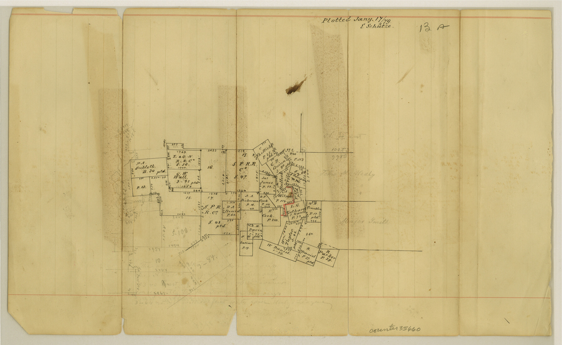
San Augustine County Sketch File 13a
[Office sketch of surveys around the A.A. Dickerson survey southwest of San Augustine]
-
Map/Doc
35660
-
Collection
General Map Collection
-
Object Dates
1/17/1879 (Creation Date)
-
People and Organizations
E. Schutze (Draftsman)
-
Counties
San Augustine
-
Subjects
Surveying Sketch File
-
Height x Width
8.9 x 14.5 inches
22.6 x 36.8 cm
-
Medium
paper, manuscript
Part of: General Map Collection
El Paso County Working Sketch 43

Print $20.00
- Digital $50.00
El Paso County Working Sketch 43
Size 22.1 x 26.1 inches
Map/Doc 69065
[Right of Way & Track Map, The Texas & Pacific Ry. Co. Main Line]
![64686, [Right of Way & Track Map, The Texas & Pacific Ry. Co. Main Line], General Map Collection](https://historictexasmaps.com/wmedia_w700/maps/64686.tif.jpg)
Print $20.00
- Digital $50.00
[Right of Way & Track Map, The Texas & Pacific Ry. Co. Main Line]
Size 11.0 x 19.0 inches
Map/Doc 64686
Flight Mission No. BQR-5K, Frame 64, Brazoria County

Print $20.00
- Digital $50.00
Flight Mission No. BQR-5K, Frame 64, Brazoria County
1952
Size 18.8 x 22.5 inches
Map/Doc 84009
Shelby County

Print $40.00
- Digital $50.00
Shelby County
1897
Size 43.9 x 49.3 inches
Map/Doc 16814
Hardin County Working Sketch 33

Print $20.00
- Digital $50.00
Hardin County Working Sketch 33
1979
Size 36.0 x 43.6 inches
Map/Doc 63431
Flight Mission No. DQO-1K, Frame 117, Galveston County

Print $20.00
- Digital $50.00
Flight Mission No. DQO-1K, Frame 117, Galveston County
1952
Size 18.9 x 22.5 inches
Map/Doc 84995
Newton County Sketch File 47

Print $20.00
- Digital $50.00
Newton County Sketch File 47
1932
Size 18.9 x 21.9 inches
Map/Doc 42159
Galveston County Rolled Sketch S

Print $20.00
- Digital $50.00
Galveston County Rolled Sketch S
1935
Size 36.0 x 46.8 inches
Map/Doc 9088
Gaines County Rolled Sketch G3

Print $20.00
- Digital $50.00
Gaines County Rolled Sketch G3
1902
Size 22.7 x 31.4 inches
Map/Doc 5946
Wilbarger County Working Sketch 11

Print $40.00
- Digital $50.00
Wilbarger County Working Sketch 11
1952
Size 27.7 x 51.7 inches
Map/Doc 72549
Coleman County Working Sketch 1

Print $20.00
- Digital $50.00
Coleman County Working Sketch 1
1900
Size 11.1 x 21.2 inches
Map/Doc 68067
Bosque County Working Sketch 27

Print $20.00
- Digital $50.00
Bosque County Working Sketch 27
2006
Size 29.8 x 38.0 inches
Map/Doc 85241
You may also like
Henderson County

Print $40.00
- Digital $50.00
Henderson County
1922
Size 33.3 x 62.4 inches
Map/Doc 1854
Brewster County Rolled Sketch 77

Print $20.00
- Digital $50.00
Brewster County Rolled Sketch 77
1944
Size 24.4 x 32.0 inches
Map/Doc 5242
Puckett Suburban Homes in Section 4, Block O

Print $20.00
- Digital $50.00
Puckett Suburban Homes in Section 4, Block O
Size 26.2 x 13.3 inches
Map/Doc 92771
Flight Mission No. DQN-2K, Frame 195, Calhoun County

Print $20.00
- Digital $50.00
Flight Mission No. DQN-2K, Frame 195, Calhoun County
1953
Size 18.6 x 22.2 inches
Map/Doc 84333
Flight Mission No. DAG-17K, Frame 62, Matagorda County

Print $20.00
- Digital $50.00
Flight Mission No. DAG-17K, Frame 62, Matagorda County
1952
Size 16.4 x 16.4 inches
Map/Doc 86324
[Capitol Leagues 217-228, 238, and vicinity]
![90674, [Capitol Leagues 217-228, 238, and vicinity], Twichell Survey Records](https://historictexasmaps.com/wmedia_w700/maps/90674-1.tif.jpg)
Print $20.00
- Digital $50.00
[Capitol Leagues 217-228, 238, and vicinity]
Size 22.8 x 10.0 inches
Map/Doc 90674
Motley County Sketch File 8 (S)

Print $4.00
- Digital $50.00
Motley County Sketch File 8 (S)
1883
Size 12.8 x 8.4 inches
Map/Doc 32153
G. C. & S. F. Ry. Northern-Division, Alignment and Right of Way Map, Weatherford Branch, Johnson and Hood Counties, Texas

Print $40.00
- Digital $50.00
G. C. & S. F. Ry. Northern-Division, Alignment and Right of Way Map, Weatherford Branch, Johnson and Hood Counties, Texas
1935
Size 37.8 x 100.5 inches
Map/Doc 64649
Flight Mission No. DCL-7C, Frame 5, Kenedy County

Print $20.00
- Digital $50.00
Flight Mission No. DCL-7C, Frame 5, Kenedy County
1943
Size 18.5 x 22.3 inches
Map/Doc 85997
A Map of the Indian Territory, Northern Texas and New Mexico showing the [G]reat Western Prairies
![97127, A Map of the Indian Territory, Northern Texas and New Mexico showing the [G]reat Western Prairies, General Map Collection](https://historictexasmaps.com/wmedia_w700/97127.tif.jpg)
Print $20.00
- Digital $50.00
A Map of the Indian Territory, Northern Texas and New Mexico showing the [G]reat Western Prairies
1844
Size 15.0 x 16.0 inches
Map/Doc 97127
Right of Way and Track Map Texas & New Orleans R.R. Co. operated by the T. & N. O. R.R. Co. Dallas-Sabine Branch

Print $40.00
- Digital $50.00
Right of Way and Track Map Texas & New Orleans R.R. Co. operated by the T. & N. O. R.R. Co. Dallas-Sabine Branch
1918
Size 25.8 x 56.1 inches
Map/Doc 64155
Engineer map showing engineer information at 23 O'Clock 23 Oct. 1918 drawn under direction of Col. W.A. Mitchell - Verso

Print $20.00
Engineer map showing engineer information at 23 O'Clock 23 Oct. 1918 drawn under direction of Col. W.A. Mitchell - Verso
1918
Size 19.7 x 12.6 inches
Map/Doc 94128