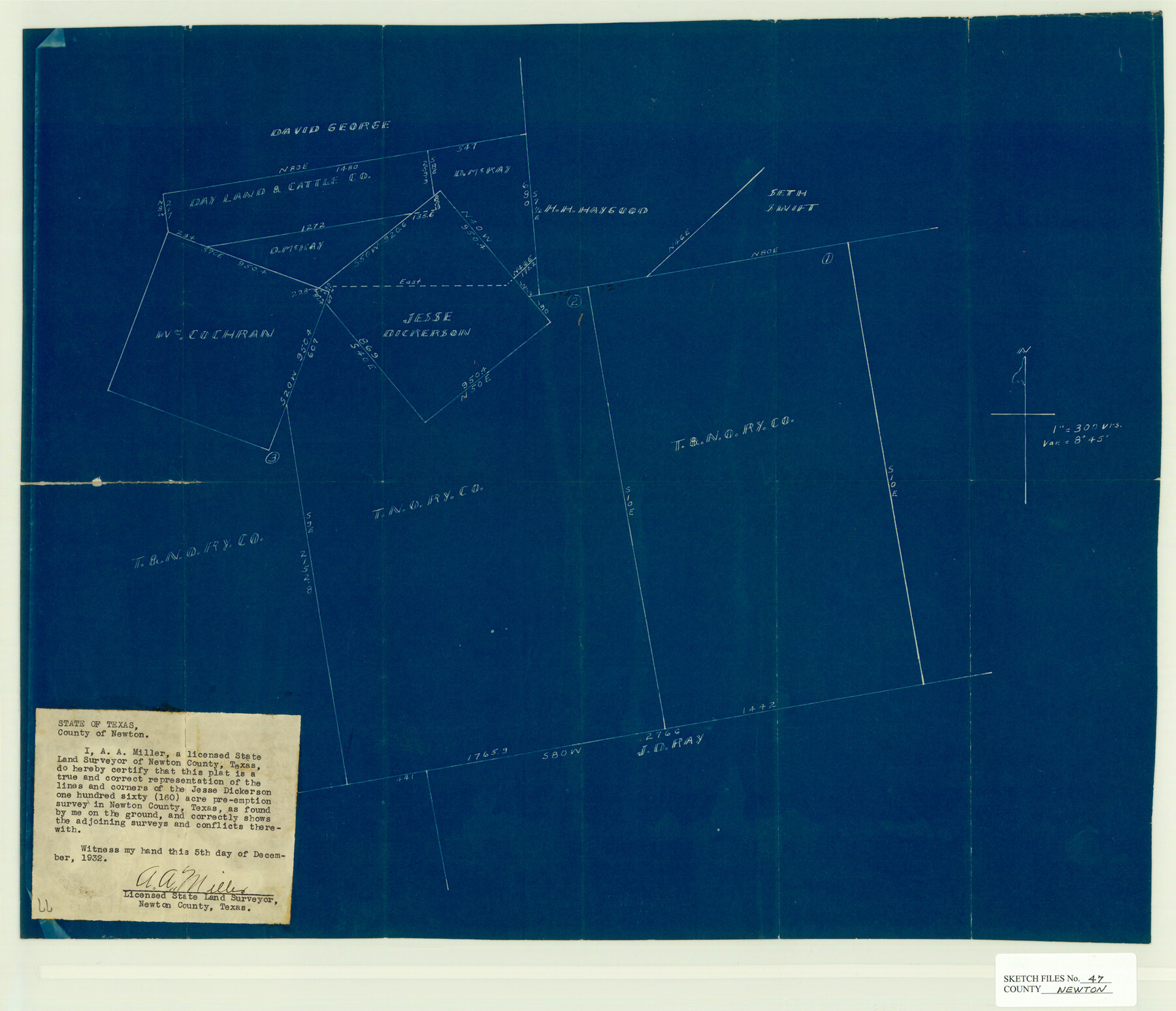
Newton County Sketch File 47
[Sketch of the Jesse Dickerson survey and surrounding area in the south part of the county]
-
Map/Doc
42159
-
Collection
General Map Collection
-
Object Dates
12/5/1932 (Creation Date)
3/22/1976 (File Date)
-
People and Organizations
A.A. Miller (Surveyor/Engineer)
-
Counties
Newton
-
Subjects
Surveying Sketch File
-
Height x Width
18.9 x 21.9 inches
48.0 x 55.6 cm
-
Medium
blueprint/diazo
-
Scale
1" = 300 varas
Part of: General Map Collection
Brazoria County Working Sketch 38

Print $40.00
- Digital $50.00
Brazoria County Working Sketch 38
1981
Size 53.2 x 37.7 inches
Map/Doc 67523
[Beaumont, Sour Lake and Western Ry. Right of Way and Alignment - Frisco]
![64128, [Beaumont, Sour Lake and Western Ry. Right of Way and Alignment - Frisco], General Map Collection](https://historictexasmaps.com/wmedia_w700/maps/64128.tif.jpg)
Print $20.00
- Digital $50.00
[Beaumont, Sour Lake and Western Ry. Right of Way and Alignment - Frisco]
1910
Size 20.1 x 45.9 inches
Map/Doc 64128
Grayson County Fannin District

Print $20.00
- Digital $50.00
Grayson County Fannin District
1885
Size 40.1 x 37.7 inches
Map/Doc 4961
Gulf Coast of the United States, Key West to Rio Grande

Print $20.00
- Digital $50.00
Gulf Coast of the United States, Key West to Rio Grande
1892
Size 27.3 x 18.3 inches
Map/Doc 72670
Colorado County Boundary File 2

Print $8.00
- Digital $50.00
Colorado County Boundary File 2
Size 14.3 x 8.7 inches
Map/Doc 51772

Hidalgo County Sketch File 9

Print $40.00
- Digital $50.00
Hidalgo County Sketch File 9
1904
Size 8.8 x 5.7 inches
Map/Doc 26409
G.C. & S.F. Ry. Alinement and Right of Way map of Dallas Branch, Ellis County, Texas

Print $20.00
- Digital $50.00
G.C. & S.F. Ry. Alinement and Right of Way map of Dallas Branch, Ellis County, Texas
1925
Size 30.9 x 44.2 inches
Map/Doc 64548
Dimmit County Working Sketch 35

Print $20.00
- Digital $50.00
Dimmit County Working Sketch 35
1961
Size 22.4 x 24.4 inches
Map/Doc 68696
Flight Mission No. DQN-3K, Frame 74, Calhoun County

Print $20.00
- Digital $50.00
Flight Mission No. DQN-3K, Frame 74, Calhoun County
1953
Size 16.2 x 16.1 inches
Map/Doc 84365
Terrell County Working Sketch 17

Print $20.00
- Digital $50.00
Terrell County Working Sketch 17
1928
Size 15.2 x 32.3 inches
Map/Doc 62166
Sabine County Working Sketch 4

Print $20.00
- Digital $50.00
Sabine County Working Sketch 4
1913
Size 23.7 x 32.0 inches
Map/Doc 63675
You may also like
Hopkins County Sketch File 7

Print $6.00
- Digital $50.00
Hopkins County Sketch File 7
Size 10.4 x 6.1 inches
Map/Doc 26692
Gillespie County Working Sketch 6

Print $20.00
- Digital $50.00
Gillespie County Working Sketch 6
1981
Size 22.5 x 21.6 inches
Map/Doc 63169
Sabine River, Dixon Sheet/Cowleach Fork of the Sabine River

Print $20.00
- Digital $50.00
Sabine River, Dixon Sheet/Cowleach Fork of the Sabine River
1935
Size 44.0 x 18.5 inches
Map/Doc 65145
Morris County Rolled Sketch 2A

Print $20.00
- Digital $50.00
Morris County Rolled Sketch 2A
Size 24.0 x 18.8 inches
Map/Doc 10246
Kansas Pacific Railway: The Best and Shortest Cattle Route from Texas

Print $20.00
Kansas Pacific Railway: The Best and Shortest Cattle Route from Texas
1872
Size 21.4 x 16.3 inches
Map/Doc 94453
Houston County Working Sketch 20

Print $20.00
- Digital $50.00
Houston County Working Sketch 20
1979
Size 26.7 x 24.0 inches
Map/Doc 66250
Flight Mission No. CUG-3P, Frame 16, Kleberg County

Print $20.00
- Digital $50.00
Flight Mission No. CUG-3P, Frame 16, Kleberg County
1956
Size 18.3 x 22.2 inches
Map/Doc 86226
The Republic County of Colorado. Spring 1842

Print $20.00
The Republic County of Colorado. Spring 1842
2020
Size 18.4 x 21.7 inches
Map/Doc 96126
Map of Neches River, Texas from Sabine Lake to Beaumont, Texas

Print $40.00
- Digital $50.00
Map of Neches River, Texas from Sabine Lake to Beaumont, Texas
1910
Size 32.4 x 104.0 inches
Map/Doc 2465
General Chart of the Coast No. XVI - Gulf Coast from Galveston to the Rio Grande

Print $20.00
- Digital $50.00
General Chart of the Coast No. XVI - Gulf Coast from Galveston to the Rio Grande
1883
Size 26.8 x 18.1 inches
Map/Doc 72737
Comanche County Working Sketch 31

Print $20.00
- Digital $50.00
Comanche County Working Sketch 31
1991
Size 28.4 x 24.2 inches
Map/Doc 68165
Red River County Working Sketch 71

Print $20.00
- Digital $50.00
Red River County Working Sketch 71
1977
Size 17.8 x 28.0 inches
Map/Doc 72054