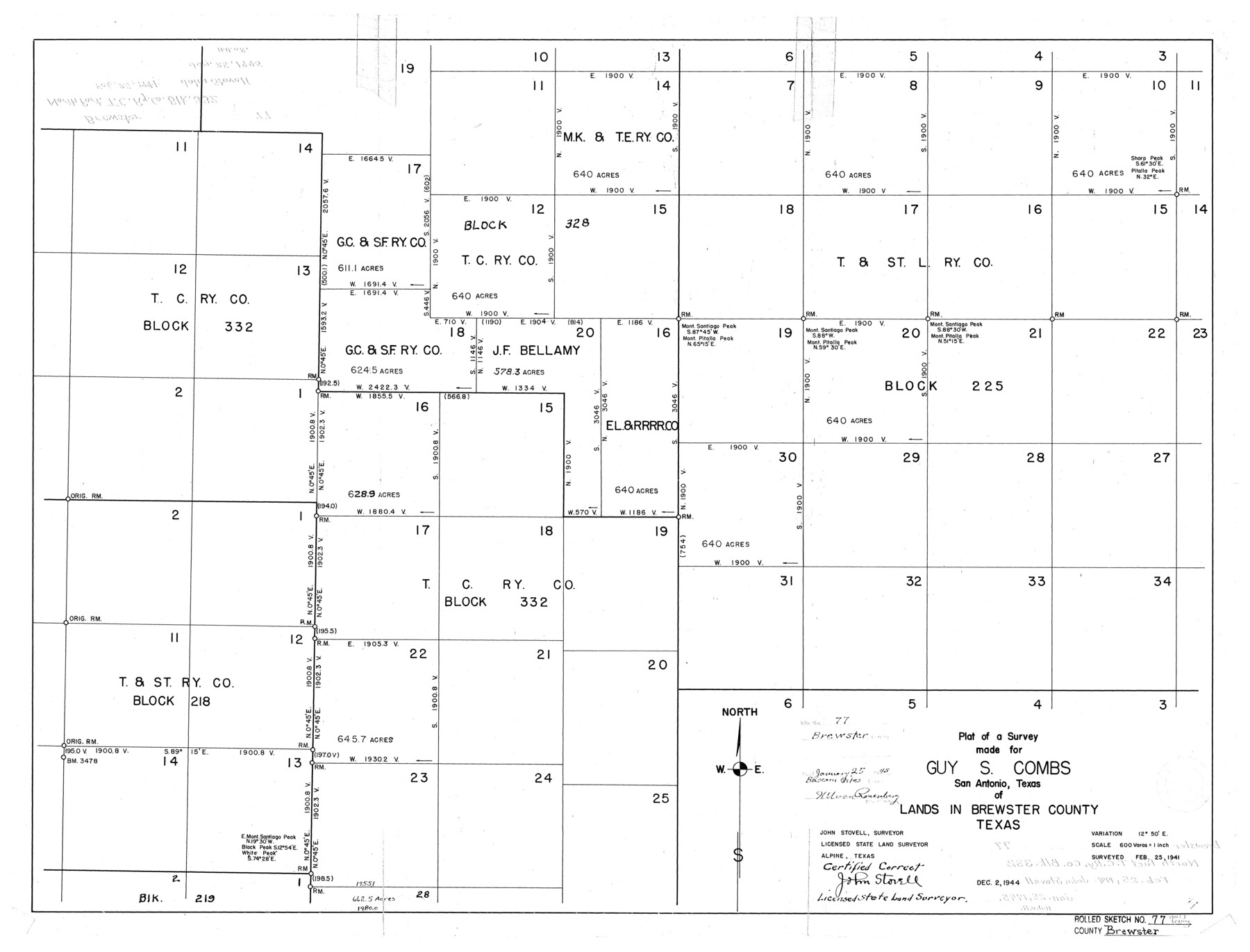
Brewster County Rolled Sketch 77
Plat of a survey made for Guy S. Combs, San Antonio, of lands in Brewster County, Texas
-
Map/Doc
5242
-
Collection
General Map Collection
-
Object Dates
1944/12/2 (Creation Date)
1945/1/25 (File Date)
1941/2/25 (Survey Date)
-
People and Organizations
John Stovell (Surveyor/Engineer)
-
Counties
Brewster
-
Subjects
Surveying Rolled Sketch
-
Height x Width
24.4 x 32.0 inches
62.0 x 81.3 cm
-
Scale
1" = 600 varas
Part of: General Map Collection
[Sabine Pass]
![78263, [Sabine Pass], General Map Collection](https://historictexasmaps.com/wmedia_w700/maps/78263.tif.jpg)
Print $20.00
- Digital $50.00
[Sabine Pass]
1916
Size 29.2 x 42.1 inches
Map/Doc 78263
Polk County Sketch File 32

Print $8.00
- Digital $50.00
Polk County Sketch File 32
1887
Size 12.8 x 8.0 inches
Map/Doc 34226

Brazoria County Sketch File 45

Print $20.00
- Digital $50.00
Brazoria County Sketch File 45
1980
Size 32.0 x 43.1 inches
Map/Doc 10326
Jefferson County Rolled Sketch 52

Print $40.00
- Digital $50.00
Jefferson County Rolled Sketch 52
Size 28.2 x 52.9 inches
Map/Doc 9308

Nueces County Sketch File 65

Print $18.00
- Digital $50.00
Nueces County Sketch File 65
1981
Size 11.2 x 8.6 inches
Map/Doc 32980
Flight Mission No. BQR-9K, Frame 13, Brazoria County

Print $20.00
- Digital $50.00
Flight Mission No. BQR-9K, Frame 13, Brazoria County
1952
Size 19.0 x 22.6 inches
Map/Doc 84042
Webb County Sketch File 44b

Print $8.00
- Digital $50.00
Webb County Sketch File 44b
1936
Size 14.5 x 9.0 inches
Map/Doc 39829
Map representing the surveys made in Bexar County

Print $40.00
- Digital $50.00
Map representing the surveys made in Bexar County
1839
Size 76.0 x 68.4 inches
Map/Doc 1947
Karnes County Boundary File 5

Print $32.00
- Digital $50.00
Karnes County Boundary File 5
Size 12.7 x 8.2 inches
Map/Doc 55705
Comanche County Sketch File 2

Print $40.00
- Digital $50.00
Comanche County Sketch File 2
1849
Size 16.0 x 12.9 inches
Map/Doc 19053
You may also like
Refugio County Sketch File 2

Print $6.00
- Digital $50.00
Refugio County Sketch File 2
1846
Size 12.6 x 7.7 inches
Map/Doc 35238
Haskell County Working Sketch 10

Print $20.00
- Digital $50.00
Haskell County Working Sketch 10
1961
Size 26.8 x 20.4 inches
Map/Doc 66068
Johnson County Working Sketch 1

Print $20.00
- Digital $50.00
Johnson County Working Sketch 1
Size 16.3 x 21.3 inches
Map/Doc 66614
New City Map of Laredo, Texas

Print $20.00
New City Map of Laredo, Texas
1930
Size 21.7 x 11.3 inches
Map/Doc 76277
Kaufman County State Real Property Sketch 2

Print $20.00
- Digital $50.00
Kaufman County State Real Property Sketch 2
2007
Size 24.2 x 35.4 inches
Map/Doc 88672
Galveston County Rolled Sketch 27B

Print $20.00
- Digital $50.00
Galveston County Rolled Sketch 27B
Size 13.1 x 10.4 inches
Map/Doc 5963
Flight Mission No. CGI-3N, Frame 78, Cameron County

Print $20.00
- Digital $50.00
Flight Mission No. CGI-3N, Frame 78, Cameron County
1954
Size 18.6 x 22.3 inches
Map/Doc 84572
Medina County Working Sketch 4

Print $40.00
- Digital $50.00
Medina County Working Sketch 4
1945
Size 52.6 x 35.5 inches
Map/Doc 70919
Hardeman County Aerial Photograph Index Sheet 2

Print $20.00
- Digital $50.00
Hardeman County Aerial Photograph Index Sheet 2
1950
Size 20.3 x 16.9 inches
Map/Doc 83698
Zapata County

Print $40.00
- Digital $50.00
Zapata County
1935
Size 56.7 x 43.2 inches
Map/Doc 63145
Wilson County

Print $40.00
- Digital $50.00
Wilson County
1921
Size 39.6 x 48.5 inches
Map/Doc 73327
Current Miscellaneous File 86

Print $6.00
- Digital $50.00
Current Miscellaneous File 86
Size 11.2 x 8.8 inches
Map/Doc 74240