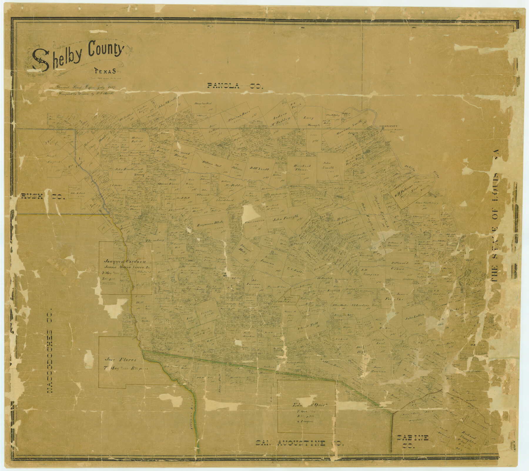
Shelby County
-
Map/Doc
16814
-
Collection
General Map Collection
-
Object Dates
1897 (Creation Date)
-
People and Organizations
Texas General Land Office (Publisher)
P.F. Appell (Draftsman)
P.F. Appell (Compiler)
-
Counties
Shelby
-
Subjects
County
-
Height x Width
43.9 x 49.3 inches
111.5 x 125.2 cm
-
Comments
Conservation funded in 2004 with donation from Larry Parker McNeill.
-
Features
Shelbyville
Center
Logansport and Brooklin Ferry
Hooper's Creek
Grigsby
Howers Creek
Sip Bayou
Taneha
Attoyac River
Hamilton
Arenilo Bayou
Dillard Creek
Bogg's Creek
South Fork of Bayou Blue
Bayou Blue
Haile
Caney Bayou
Huana Bayou
Baer Bayou
Stockman
Flat Fork of Taneha Bayou
Sabine River
Taneha Bayou
Timpson
Brooklin
Brooklin Post Office
McFadden Creek
Joaquin
Brooklin Ferry
Logansport Ferry
Logansport
Part of: General Map Collection
Cooke County Working Sketch 38

Print $40.00
- Digital $50.00
Cooke County Working Sketch 38
1997
Size 48.2 x 36.6 inches
Map/Doc 68275
McMullen County Rolled Sketch 7

Print $40.00
- Digital $50.00
McMullen County Rolled Sketch 7
1939
Size 38.8 x 51.7 inches
Map/Doc 9500
Ellis County Sketch File 4

Print $4.00
- Digital $50.00
Ellis County Sketch File 4
1859
Size 13.0 x 8.5 inches
Map/Doc 21832
Flight Mission No. DAG-14K, Frame 146, Matagorda County

Print $20.00
- Digital $50.00
Flight Mission No. DAG-14K, Frame 146, Matagorda County
1952
Size 18.4 x 22.2 inches
Map/Doc 86313
Aransas County NRC Article 33.136 Sketch 8

Print $22.00
- Digital $50.00
Aransas County NRC Article 33.136 Sketch 8
2007
Size 24.0 x 36.0 inches
Map/Doc 88800
Presidio County Rolled Sketch 54

Print $20.00
- Digital $50.00
Presidio County Rolled Sketch 54
1913
Size 17.1 x 18.5 inches
Map/Doc 7348
Burleson County Working Sketch 6

Print $20.00
- Digital $50.00
Burleson County Working Sketch 6
1980
Size 22.3 x 16.0 inches
Map/Doc 67725

Bastrop County

Print $20.00
- Digital $50.00
Bastrop County
1917
Size 45.5 x 40.8 inches
Map/Doc 66711
Donley County Sketch File 18 (2a)

Print $2.00
- Digital $50.00
Donley County Sketch File 18 (2a)
Size 10.3 x 8.0 inches
Map/Doc 21255

Map of Galveston Bay from Lawrence Cove to Stevenson's Station

Print $20.00
- Digital $50.00
Map of Galveston Bay from Lawrence Cove to Stevenson's Station
1851
Size 41.5 x 30.0 inches
Map/Doc 69922
You may also like
Flight Mission No. DQO-8K, Frame 143, Galveston County

Print $20.00
- Digital $50.00
Flight Mission No. DQO-8K, Frame 143, Galveston County
1952
Size 18.6 x 22.5 inches
Map/Doc 85205
Briscoe County Sketch File P

Print $40.00
- Digital $50.00
Briscoe County Sketch File P
Size 23.1 x 34.0 inches
Map/Doc 11014
Terrell County Working Sketch 72

Print $20.00
- Digital $50.00
Terrell County Working Sketch 72
1980
Size 14.3 x 24.8 inches
Map/Doc 69593
Hale County Sketch File 14

Print $8.00
- Digital $50.00
Hale County Sketch File 14
Size 14.1 x 8.7 inches
Map/Doc 24743
Padre Island Under Six Flags

Print $40.00
- Digital $50.00
Padre Island Under Six Flags
1962
Size 59.3 x 30.3 inches
Map/Doc 3123
Flight Mission No. CUG-1P, Frame 51, Kleberg County

Print $20.00
- Digital $50.00
Flight Mission No. CUG-1P, Frame 51, Kleberg County
1956
Size 18.7 x 22.3 inches
Map/Doc 86129
Kimble County Working Sketch 97

Print $20.00
- Digital $50.00
Kimble County Working Sketch 97
2012
Size 42.8 x 36.6 inches
Map/Doc 93388
Yellowhouse Land Company's Subdivision of State Capitol Leagues Hockley County, Texas

Print $20.00
- Digital $50.00
Yellowhouse Land Company's Subdivision of State Capitol Leagues Hockley County, Texas
Size 30.7 x 24.9 inches
Map/Doc 92260
Culberson County Working Sketch 59

Print $20.00
- Digital $50.00
Culberson County Working Sketch 59
1974
Size 46.4 x 37.7 inches
Map/Doc 68513
Menard County Rolled Sketch 15

Print $20.00
- Digital $50.00
Menard County Rolled Sketch 15
1983
Size 27.9 x 22.0 inches
Map/Doc 6761
Journal of the Joint Commission

Print $35.00
- Digital $50.00
Journal of the Joint Commission
1838
Size 9.3 x 6.1 inches
Map/Doc 65515
[Runnels County School Land and river surveys adjacent]
![91580, [Runnels County School Land and river surveys adjacent], Twichell Survey Records](https://historictexasmaps.com/wmedia_w700/maps/91580-1.tif.jpg)
Print $2.00
- Digital $50.00
[Runnels County School Land and river surveys adjacent]
1945
Size 13.5 x 8.7 inches
Map/Doc 91580