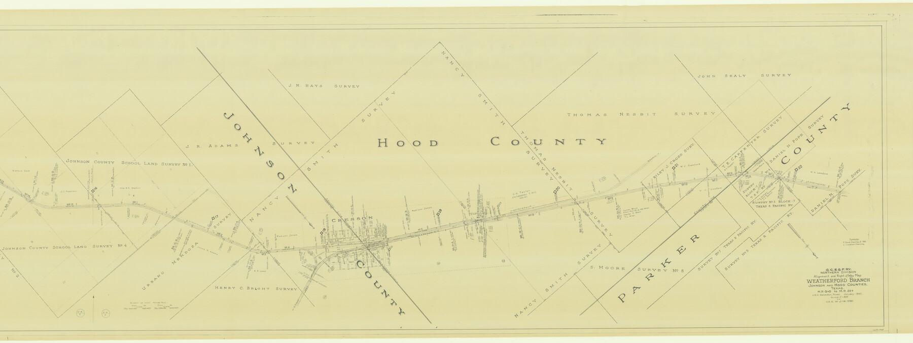
G. C. & S. F. Ry. Northern-Division, Alignment and Right of Way Map, Weatherford Branch, Johnson and Hood Counties, Texas
M.P. 0+0 to M.P. 22+
Z-2-168
-
Map/Doc
64649
-
Collection
General Map Collection
-
Object Dates
1935 (Creation Date)
1943/6/25 (File Date)
-
Counties
Tarrant Johnson Hood
-
Subjects
Railroads
-
Height x Width
37.8 x 100.5 inches
96.0 x 255.3 cm
-
Medium
blueprint/diazo
-
Scale
1" = 400 feet
-
Comments
See counter nos. 64647, 64648 and 64650 through 64654 for other segments.
-
Features
GC&SF
State Highway 122
[Railroad line] to Granbury
FW&RG
Cresson
[Railroad line] to Fort Worth
Part of: General Map Collection
Cherokee County Sketch File 19

Print $4.00
- Digital $50.00
Cherokee County Sketch File 19
1876
Size 8.2 x 8.4 inches
Map/Doc 18161
Wichita County Sketch File 23a

Print $10.00
- Digital $50.00
Wichita County Sketch File 23a
1911
Size 14.2 x 8.8 inches
Map/Doc 40109
Flight Mission No. CUG-2P, Frame 65, Kleberg County

Print $20.00
- Digital $50.00
Flight Mission No. CUG-2P, Frame 65, Kleberg County
1956
Size 18.5 x 22.1 inches
Map/Doc 86202
Flight Mission No. CRC-6R, Frame 40, Chambers County

Print $20.00
- Digital $50.00
Flight Mission No. CRC-6R, Frame 40, Chambers County
1956
Size 18.6 x 22.5 inches
Map/Doc 84973
Duval County Working Sketch 41

Print $20.00
- Digital $50.00
Duval County Working Sketch 41
1963
Size 24.1 x 22.9 inches
Map/Doc 68765
Gray County Sketch File 10

Print $14.00
- Digital $50.00
Gray County Sketch File 10
Size 9.7 x 6.3 inches
Map/Doc 24445
Polk County Sketch File 11a

Print $4.00
- Digital $50.00
Polk County Sketch File 11a
Size 8.1 x 9.7 inches
Map/Doc 34144
Reeves County Sketch File 3

Print $8.00
- Digital $50.00
Reeves County Sketch File 3
Size 14.4 x 8.8 inches
Map/Doc 35188

Throckmorton County Sketch File 6

Print $27.00
- Digital $50.00
Throckmorton County Sketch File 6
1888
Size 9.0 x 6.9 inches
Map/Doc 38076
Texas, Corpus Christi, Corpus Christi to Laguna Madre

Print $40.00
- Digital $50.00
Texas, Corpus Christi, Corpus Christi to Laguna Madre
1934
Size 35.1 x 48.6 inches
Map/Doc 73457
[Neches River Bed, Plat and Calculations]
![77101, [Neches River Bed, Plat and Calculations], General Map Collection](https://historictexasmaps.com/wmedia_w700/maps/77101.tif.jpg)
Print $20.00
- Digital $50.00
[Neches River Bed, Plat and Calculations]
1928
Size 23.2 x 19.8 inches
Map/Doc 77101
You may also like
Supreme Court of the United States, October Term, 1930, No.2, Original - The State of New Mexico, Complainant vs. The State of Texas, Defendant

Print $138.00
- Digital $50.00
Supreme Court of the United States, October Term, 1930, No.2, Original - The State of New Mexico, Complainant vs. The State of Texas, Defendant
Size 9.2 x 6.0 inches
Map/Doc 95287
Flight Mission No. BRA-16M, Frame 101, Jefferson County

Print $20.00
- Digital $50.00
Flight Mission No. BRA-16M, Frame 101, Jefferson County
1953
Size 18.6 x 22.4 inches
Map/Doc 85713
Webb County Sketch File 59

Print $8.00
- Digital $50.00
Webb County Sketch File 59
1943
Size 14.4 x 9.0 inches
Map/Doc 39851
Flight Mission No. DIX-6P, Frame 201, Aransas County

Print $20.00
- Digital $50.00
Flight Mission No. DIX-6P, Frame 201, Aransas County
1956
Size 18.9 x 22.8 inches
Map/Doc 83863
Kendall County Sketch File 13

Print $4.00
- Digital $50.00
Kendall County Sketch File 13
1860
Size 10.1 x 8.0 inches
Map/Doc 28699
San Jacinto County Working Sketch Graphic Index

Print $20.00
- Digital $50.00
San Jacinto County Working Sketch Graphic Index
1942
Size 44.9 x 40.6 inches
Map/Doc 76691
Map of Abilene

Print $20.00
- Digital $50.00
Map of Abilene
1885
Size 24.6 x 27.4 inches
Map/Doc 3042
The Republic County of Bexar. November 28, 1839

Print $20.00
The Republic County of Bexar. November 28, 1839
2020
Size 14.8 x 21.1 inches
Map/Doc 96097
Loving County Working Sketch 16a

Print $20.00
- Digital $50.00
Loving County Working Sketch 16a
1976
Size 45.4 x 29.3 inches
Map/Doc 70650
Hardin County Working Sketch 34

Print $20.00
- Digital $50.00
Hardin County Working Sketch 34
1980
Size 15.7 x 12.1 inches
Map/Doc 63432
Map of Burleson County

Print $20.00
- Digital $50.00
Map of Burleson County
1867
Size 19.1 x 30.0 inches
Map/Doc 4511
Eastland County

Print $20.00
- Digital $50.00
Eastland County
1945
Size 41.8 x 42.0 inches
Map/Doc 77268